| This article needs additional citations for verification. Please help improve this article by adding citations to reliable sources. Unsourced material may be challenged and removed. Find sources: "East Webburn River" – news · newspapers · books · scholar · JSTOR (January 2025) (Learn how and when to remove this message) |
| East Webburn River | |
|---|---|
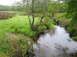
 The East Webburn River passing close to Widecombe The East Webburn River passing close to Widecombe | |
  | |
| Location | |
| Country | England |
| County | Devon |
| Physical characteristics | |
| Source | Dartmoor moors |
| Mouth | Lizwell Meet |
| • location | Oakmoor Wood |
| • coordinates | 50°32′56″N 3°49′03″W / 50.5488°N 3.8175°W / 50.5488; -3.8175 |
| Length | 5 miles (8 km) |
The East Webburn is a 5-mile (8 km) stream in the Dartmoor moors in Devon in south-west England. It rises on the western side of the moors, flowing off the west side of Hameldown ridge. Its source is around 1⁄2 mile (0.80 km) southwest of Grimspound Bronze Age settlement. It flows south past Widecombe-in-the-Moor and joins the West Webburn River at Lizwell Meet in Oakmoor Wood. These combined streams then join the River Dart close to the village of Holne.
References
- "East Webburn River Water Body". GOV.UK. Department for Environment Food & Rural Affairs.
- Okehampton and North Dartmoor (Landranger Map 191) (D ed.), Ordnance Survey, 2007, ISBN 978-0-319-22864-7
| Rivers of Dartmoor, Devon, England | |
|---|---|
This article related to a river in England is a stub. You can help Misplaced Pages by expanding it. |