Human settlement in England
| Routenbeck | |
|---|---|
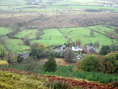
 Looking down to Routenbeck Looking down to Routenbeck | |
  | |
| OS grid reference | NY194303 |
| Civil parish | |
| District | |
| Shire county | |
| Region | |
| Country | England |
| Sovereign state | United Kingdom |
| Post town | COCKERMOUTH |
| Postcode district | CA13 |
| Dialling code | 017687 |
| Police | Cumbria |
| Fire | Cumbria |
| Ambulance | North West |
| UK Parliament | |
| 54°39′43″N 3°14′56″W / 54.662°N 3.249°W / 54.662; -3.249 | |
Routenbeck is a hamlet in Cumbria, England. It is located at the northern foot of Sale Fell, near the north-west edge of Bassenthwaite Lake. Routenbeck is just over 2 miles south-west of the village of Bassenthwaite and 5 miles east of the town of Cockermouth. It contains an Old Vicarage. The nearest pub is the Pheasant Inn, about a third of a mile along the road to the north-east.
References
- Financial Times Healthcare-Division of Pearson Professional; Royal Society of Medicine (Great Britain); Cartermill (1998). Medical directory. J. & A. Churchill ltd. p. 363. Retrieved 19 July 2012.
This Cumbria location article is a stub. You can help Misplaced Pages by expanding it. |