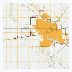
Rural municipality in Saskatchewan, Canada
| Sherwood No. 159 | |
|---|---|
| Rural municipality | |
| Rural Municipality of Sherwood No. 159 | |
 | |
 Location of the RM of Sherwood No. 159 in Saskatchewan Location of the RM of Sherwood No. 159 in Saskatchewan | |
| Coordinates: 50°28′23″N 104°37′37″W / 50.473°N 104.627°W / 50.473; -104.627 | |
| Country | Canada |
| Province | Saskatchewan |
| Census division | 6 |
| SARM division | 2 |
| Federal riding | Moose Jaw—Lake Centre—Lanigan Regina—Qu'Appelle |
| Provincial riding | Indian Head-Milestone Lumsden-Morse |
| Formed | December 11, 1911 |
| Government | |
| • Reeve | Sue Oakley-Paul |
| • Governing body | RM of Sherwood No. 159 Council |
| • Administrator | Bradley Wiebe |
| • Office location | Regina |
| Area | |
| • Land | 656.87 km (253.62 sq mi) |
| Population | |
| • Total | 974 |
| • Density | 1.5/km (4/sq mi) |
| Time zone | CST |
| • Summer (DST) | CST |
| Postal code | S4W 0L3 |
| Area code(s) | 306 and 639 |
| Website | Official website |
The Rural Municipality of Sherwood No. 159 (2016 population: 974) is a rural municipality (RM) in the Canadian province of Saskatchewan within Census Division No. 6 and SARM Division No. 2. In the south-central portion of the province, it surrounds the city of Regina, the provincial capital, and forms part of the Regina census metropolitan area.
History
The RM of Sherwood No. 159 incorporated as a rural municipality on December 11, 1911. The RM was named after the Sherwood School District No. 460, which itself was named after Sherwood, Ontario, where some of the early settlers to the area originated from.
Heritage properties
The RM has two heritage properties.
- Boggy Creek School - Built in 1923 as a One-room school, the building was used as a school until 1965. After that point it was used by Regina Board of Education for an outdoor program. The site had an older school building dating back to 1886. The school is located 10 km northwest of Regina. The building is of brick construction based on a Waterman-Waterbury Company design.
- Normand Farm Residence - Built in 1905 as a homestead the two story residence is made from field-stone and brick. Still in use as a residence the building is located on Zehner Road,
Geography
The RM features heavy clay soils, making it one of the richest farming areas in the province. The Wascana Valley and Wascana Creek meander through the RM. The Sherwood Forest Bridge crosses Wascana Creek within the RM.
At the north-west corner of the RM, in the Wascana Valley, is the Wascana Trails provincial recreation site.
Communities and localities
The following urban municipalities are surrounded by the RM.
Cities
Towns
Demographics
| Year | Pop. | ±% |
|---|---|---|
| 1981 | 1,329 | — |
| 1986 | 1,218 | −8.4% |
| 1991 | 1,098 | −9.9% |
| 1996 | 1,056 | −3.8% |
| 2001 | 1,054 | −0.2% |
| 2006 | 1,075 | +2.0% |
| 2011 | 929 | −13.6% |
| 2016 | 974 | +4.8% |
| Source: Statistics Canada via Saskatchewan Bureau of Statistics | ||
In the 2021 Census of Population conducted by Statistics Canada, the RM of Sherwood No. 159 had a population of 1,219 living in 274 of its 302 total private dwellings, a change of 25.2% from its 2016 population of 974. With a land area of 656.66 km (253.54 sq mi), it had a population density of 1.9/km (4.8/sq mi) in 2021.
In the 2016 Census of Population, the RM of Sherwood No. 159 recorded a population of 974 living in 309 of its 325 total private dwellings, a 10.8% change from its 2011 population of 879. With a land area of 656.87 km (253.62 sq mi), it had a population density of 1.5/km (3.8/sq mi) in 2016.
Economy
The Sherwood Industrial Park is also within the RM, which is a home to the steel manufacturer Evraz (formerly IPSCO), agricultural implement manufacturers and dealerships, trucking companies, and medical hazardous waste disposal facilities.
Government
The RM of Sherwood No. 159 is governed by an elected municipal council and an appointed administrator that meets on the second Wednesday of every month. The reeve of the RM is Susan Oakley-Paul while its administrator is Bradley Wiebe. The RM's office is located in Regina.
See also
References
- "Pre-packaged CSV files - CGN, Canada/Province/Territory (cgn_sk_csv_eng.zip)". Government of Canada. July 24, 2019. Retrieved May 23, 2020.
- ^ "Rural Municipality Incorporations (Alphabetical)". Saskatchewan Ministry of Municipal Affairs. Archived from the original on April 21, 2011. Retrieved May 9, 2020.
- ^ "Municipality Details: RM of Sherwood No. 159". Government of Saskatchewan. Retrieved May 21, 2020.
- ^ "Population and dwelling counts, for Canada, provinces and territories, and census subdivisions (municipalities), 2016 and 2011 censuses – 100% data (Saskatchewan)". Statistics Canada. February 8, 2017. Retrieved May 1, 2020.
- Sask Biz
- Boggy Creek School
- Normand Farm Residence
- "Saskatchewan Census Population" (PDF). Saskatchewan Bureau of Statistics. Archived from the original (PDF) on September 24, 2015. Retrieved May 9, 2020.
- "Saskatchewan Census Population". Saskatchewan Bureau of Statistics. Retrieved May 9, 2020.
- "Population and dwelling counts: Canada, provinces and territories, census divisions and census subdivisions (municipalities), Saskatchewan". Statistics Canada. February 9, 2022. Retrieved April 13, 2022.
