| São Valentim | |
|---|---|
| Bairro | |
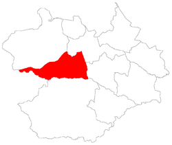
 The bairro in District of São Valentim The bairro in District of São Valentim | |
 District of São Valentim, in Santa Maria City, Rio Grande do Sul, Brazil District of São Valentim, in Santa Maria City, Rio Grande do Sul, Brazil | |
| Coordinates: 29°45′04.65″S 53°53′43.61″W / 29.7512917°S 53.8954472°W / -29.7512917; -53.8954472 | |
| Country | Brazil |
| State | Rio Grande do Sul |
| Municipality/City | Santa Maria |
| District | District of São Valentim |
| Area | |
| • Total | 133.3800 km (51.4983 sq mi) |
| Population | |
| • Total | 565 |
| • Density | 4.2/km (11/sq mi) |
| Adjacent bairros | Boca do Monte, Boi Morto, Lorenzi, Pains, Renascença, Santa Flora, Tancredo Neves, Urlândia. |
| Website | Official site of Santa Maria |
São Valentim (Portuguese pronunciation: [ˈsãw valẽˈtĩ], "Saint Valentine") is a bairro in the District of São Valentim in the municipality of Santa Maria, in the Brazilian state of Rio Grande do Sul. It is situated in south of Santa Maria.
Villages
The bairro contains the following villages: Alto das Palmeiras, Área Militar, Capão do Piquenique, Colônia Conceição, Colônia Toniolo, Laranjeiras, Passo da Laranjeira, Passo do Sarandi, Picadinha, Rincão da Lagoa, Rincão dos Brasil, Rincão dos Flores, São Valentim, Vila São Valentim.
Gallery of photos
| Places adjacent to São Valentim, Santa Maria | ||||||||||||||||
|---|---|---|---|---|---|---|---|---|---|---|---|---|---|---|---|---|
| ||||||||||||||||
References
- Population of the territories of Santa Maria. Brazilian Institute of Geography and Statistics in Portuguese.
- Municipal Law 0072 of 2009 that establishes the law of use and occupation of the soil, subdivision, urban perimeter and road system of the municipality of Santa Maria. - in Portuguese
 | This geographical article relating to Rio Grande do Sul is a stub. You can help Misplaced Pages by expanding it. |