| This article needs additional citations for verification. Please help improve this article by adding citations to reliable sources. Unsourced material may be challenged and removed. Find sources: "Sanasar" – news · newspapers · books · scholar · JSTOR (August 2014) (Learn how and when to remove this message) |
| Sanasar | |
|---|---|
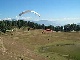
 Paragliding at Sanasar Paragliding at Sanasar | |
  | |
| Floor elevation | 6,730 ft (2,050 m) |
| Geography | |
| Country | India |
| State | Jammu and Kashmir |
| Region | Chenab valley |
| District | Ramban District |
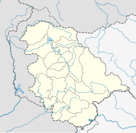
| Coordinates | 33°07′30″N 75°15′36″E / 33.125°N 75.260°E / 33.125; 75.260 |
Sanasar is a tourist destination and the name given to the two small villages of Sana and Sar in Ramban District, Jammu and Kashmir, India.
Named after small local lakes, Sana and Sar are located 20 kilometres (12 mi) west of Patnitop, Ramban district on the national highway 1A. At an altitude of 2,050 metres (6,730 ft), it is the hub for adventure and sport activities in the Jammu region. The area is notable for its scenic views of mountain ranges including the Brammah Massif.

Nearby sights

A nearby mountain range is called the Shanta Ridge. The Shank Pal Temple is located at the highest point of the Shank Pal ridge, at an altitude of 2,897 metres (9,505 ft), a few hours' walk from Sanasar. The 400-year-old temple is dedicated to Nag Shankh Pal. No mortar was used to join the stones of the temple.
Shanta Gala is a pass on the Shanta ridge which offers a view of the Panchari valley on the other side of the ridge. The pass leads to the Lander area.
References
- "Trekking to Shankhpal - A perfect camping ground — inditramp". Archived from the original on 4 August 2014. Retrieved 1 August 2014.
- "10 Lesser Known Places to Visit in Jammu". Archived from the original on 8 December 2015. Retrieved 1 December 2015.
This article related to a location in Jammu and Kashmir is a stub. You can help Misplaced Pages by expanding it. |