| Sant'Agata Bolognese | |
|---|---|
| Comune | |
| Comune di Sant'Agata Bolognese | |
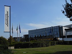
 Headquarters of Lamborghini Headquarters of Lamborghini | |
 Coat of arms Coat of arms | |
| Location of Sant'Agata Bolognese | |
  | |
| Coordinates: 44°39′45″N 11°08′00″E / 44.66250°N 11.13333°E / 44.66250; 11.13333 | |
| Country | Italy |
| Region | Emilia-Romagna |
| Metropolitan city | Bologna (BO) |
| Government | |
| • Mayor | Giuseppe Vicinelli |
| Area | |
| • Total | 34 km (13 sq mi) |
| Elevation | 21 m (69 ft) |
| Population | |
| • Total | 7,283 |
| • Density | 210/km (550/sq mi) |
| Demonym | Santagatesi |
| Time zone | UTC+1 (CET) |
| • Summer (DST) | UTC+2 (CEST) |
| Postal code | 40019 |
| Dialing code | 051 |
| Patron saint | St. Agatha |
| Website | Official website |

Sant'Agata Bolognese (Western Bolognese: Sant'Èghete; City Bolognese: Sant'Ègata) is a small comune in the Metropolitan City of Bologna, Emilia-Romagna, in the north of Italy. It is notable for being the headquarters of the luxury automobile manufacturer Automobili Lamborghini.
It is named after Saint Agatha of Sicily.
Economy
From the industry it is internationally known for hosting the headquarters of Lamborghini, which emerged as a company producing agricultural machinery, and later became a company of automobileis luxury.
Famous people
- Nilla Pizzi, singer.
- Cinzia Bomoll, writer.
- Luciano Bovina, photoreporter and documentarian.
- Gilberto Canu, architect and writer.
- Ferruccio Lamborghini, founder of Lamborghini.
Demographics
|
|
| ||||||||||||||||||||||||||||||||||||||||||||||||||||||
| Source: ISTAT Source | ||||||||||||||||||||||||||||||||||||||||||||||||||||||||
References
- "Superficie di Comuni Province e Regioni italiane al 9 ottobre 2011". Italian National Institute of Statistics. Retrieved 16 March 2019.
- Demographics data from ISTAT
This article on a location in Emilia–Romagna is a stub. You can help Misplaced Pages by expanding it. |