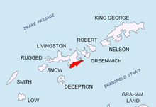


Sitalk Peak (Bulgarian: връх Ситалк, romanized: vrah Sitalk, IPA: [ˈvrɤx siˈtaɫk]) is a rocky peak of elevation 600 m in Levski Ridge, Tangra Mountains, Livingston Island in the South Shetland Islands, Antarctica. Situated at the end of a side ridge running northwards from Great Needle Peak, and linked to a rocky part of that ridge featuring Tutrakan Peak to the south by a 100-metre long ice-covered saddle. Surmounting Huron Glacier and its tributaries to the north, east and west. The peak is named after the Thracian King Sitalk, 431-424 BC.
Location
The peak is located at 62°38′49.7″S 60°03′38″W / 62.647139°S 60.06056°W / -62.647139; -60.06056, which is 700 m north of Tutrakan Peak, 750 m northeast of Plana Peak, 1.46 km east of Nestinari Nunataks, 1.93 km southeast of Kukeri Nunataks and 1.34 km west-southwest of Intuition Peak (Bulgarian topographic survey Tangra 2004/05, and mapping in 2005 and 2009).
Maps
- L.L. Ivanov et al. Antarctica: Livingston Island and Greenwich Island, South Shetland Islands. Scale 1:100000 topographic map. Sofia: Antarctic Place-names Commission of Bulgaria, 2005.
- L.L. Ivanov. Antarctica: Livingston Island and Greenwich, Robert, Snow and Smith Islands. Scale 1:120000 topographic map. Troyan: Manfred Wörner Foundation, 2009. ISBN 978-954-92032-6-4
- A. Kamburov and L. Ivanov. Bowles Ridge and Central Tangra Mountains: Livingston Island, Antarctica. Scale 1:25000 map. Sofia: Manfred Wörner Foundation, 2023. ISBN 978-619-90008-6-1
References
- Sitalk Peak. SCAR Composite Antarctic Gazetteer
- Bulgarian Antarctic Gazetteer. Antarctic Place-names Commission. (details in Bulgarian, basic data in English)
External links
- Sitalk Peak. Copernix satellite image
This article includes information from the Antarctic Place-names Commission of Bulgaria which is used with permission.
This Livingston Island location article is a stub. You can help Misplaced Pages by expanding it. |