| This article relies largely or entirely on a single source. Relevant discussion may be found on the talk page. Please help improve this article by introducing citations to additional sources. Find sources: "Boulevard Des Sources" – news · newspapers · books · scholar · JSTOR (June 2017) |


| Des Sources Boulevard | |
| Major junctions | |
|---|---|
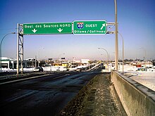
Des Sources Boulevard is a north-south artery located in the west of the island of Montreal, informally known locally as the West Island.
The boulevard crosses the island completely from north to south. In the south, it starts at the intersection of Chemin du Bord-du-Lac and intersects Highway 20 at Exit 53. It then intersects Highway 40 at Exit 55. Thereafter, it crosses the city of Dollard-des-Ormeaux and reaches Pierrefonds Boulevard and Gouin Boulevard in the north. It ends on Debours Street in a newly built residential area.
History
Des Sources goes back to the 1700s when it facilitated the movement from one concession to the next — hence its former name “montée des Sources”. It was designated a boulevard only in 1961.
Public transport
The 209 Des Sources serves the boulevard starting from YUL Montréal Trudeau airport to Roxboro Pierrfonds REM station. The 409 Express Des Sources goes from Av. Anselme-Lavigne to Du College metro station.
See also
- Boulevard Saint-Jean – parallel artery to Boulevard des Sources to the west
- Boulevard Saint-Charles – parallel artery to Boulevard des Sources to the west
References
External links
![]() Media related to Boulevard des Sources at Wikimedia Commons
Media related to Boulevard des Sources at Wikimedia Commons
This Quebec road, road transport or highway-related article is a stub. You can help Misplaced Pages by expanding it. |