| Sveta Ema | |
|---|---|
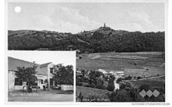
 Postcard of Sveta Ema Postcard of Sveta Ema | |
 | |
| Coordinates: 46°10′49.36″N 15°36′38.16″E / 46.1803778°N 15.6106000°E / 46.1803778; 15.6106000 | |
| Country | |
| Traditional region | Styria |
| Statistical region | Savinja |
| Municipality | Podčetrtek |
| Area | |
| • Total | 1.38 km (0.53 sq mi) |
| Elevation | 316 m (1,037 ft) |
| Population | |
| • Total | 178 |
Sveta Ema (pronounced [ˈsʋeːta ˈeːma]) is a settlement in the Municipality of Podčetrtek in eastern Slovenia. The area around Podčetrtek is part of the traditional region of Styria. It is now included in the Savinja Statistical Region.
The settlement gets its name from the parish church, dedicated to Saint Hemma. It belongs to the Roman Catholic Diocese of Celje. It was built in 1717.
References
- Statistical Office of the Republic of Slovenia
- Podčetrtek Municipality site
- Slovenian Ministry of Culture register of national heritage reference number 2962
External links
| Municipality of Podčetrtek | ||||||
|---|---|---|---|---|---|---|
| Settlements | Administrative seat: Podčetrtek
|  | ||||
| Landmarks | ||||||
This article about the Municipality of Podčetrtek in Slovenia is a stub. You can help Misplaced Pages by expanding it. |