| Spišská Belá | |
|---|---|
| Town | |
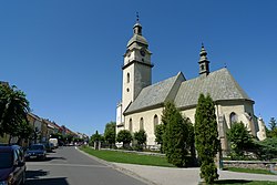
 Church in Spišská Belá Church in Spišská Belá | |
 Coat of arms Coat of arms | |
  | |
| Coordinates: 49°11′09″N 20°27′24″E / 49.18583°N 20.45667°E / 49.18583; 20.45667 | |
| Country | |
| Region | Prešov |
| District | Kežmarok |
| First mentioned | 1263 |
| Government | |
| • Mayor | Jozef Kuna |
| Area | |
| • Total | 33.89 km (13.09 sq mi) |
| Elevation | 622 m (2,041 ft) |
| Population | |
| • Total | 6,668 |
| • Density | 200/km (510/sq mi) |
| Time zone | UTC+1 (CET) |
| • Summer (DST) | UTC+2 (CEST) |
| Postal code | 059 01 |
| Area code | +421 52 |
| Car plate | KK |
| Website | spisskabela.sk |
Spišská Belá (German: Zipser Bela; Hungarian: Szepesbéla; Rusyn: Спіська Бела; Polish: Biała Spiska) is a town in the Kežmarok District in the Prešov Region in Spiš in northern Slovakia. Prior to World War I, it was in Szepes county in the Kingdom of Hungary.
History
The town was first mentioned in historical records in 1263. The town received town rights in 1271. Scientist and inventor Joseph Petzval was born here in 1807. The town center has been designated an historic district. The church in the center of the square was built in the 15th century. The tower next to the church was dedicated to when to town received town rights back in 1271.
In 1910 the town had 2,894 inhabitants, half of them were Slovaks and the other half Germans. The town was mainly Catholic but also had a significant Lutheran minority. It was part of the German language island of the Oberzips. Before the establishment of independent Czechoslovakia in 1918, Spišská Belá was part of Szepes County within the Kingdom of Hungary. From 1939 to 1945, it was part of the Slovak Republic. On 27 January 1945, the Red Army dislodged the Wehrmacht from Spišská Belá in the course of the Western Carpathian offensive and it was once again part of Czechoslovakia. After the end of World War II the German population was expelled according to the Beneš decrees.
Geography
The town and municipality lies at an altitude of 631 metres and covers an area of 33.94 km². It has a population of about 6,189 people.
Demographics
| Year | Pop. | ±% |
|---|---|---|
| 1970 | 4,951 | — |
| 1980 | 5,225 | +5.5% |
| 1991 | 5,408 | +3.5% |
| 2001 | 6,136 | +13.5% |
| 2011 | 6,387 | +4.1% |
| 2021 | 6,646 | +4.1% |
| Source: Censuses | ||
According to the 2001 census, the town had 6,136 inhabitants. 94.82% of inhabitants were Slovaks, 3.18% Roma, 0.31% Czechs and 0.26% Germans. The religious makeup was 85.46% Roman Catholics, 4.61% people with no religious affiliation, 3.49% Lutherans and 1.22% Greek Catholics.
Famous people
- Joseph Petzval, scientist and inventor
Twin towns — sister cities
See also: List of twin towns and sister cities in SlovakiaSpišská Belá is twinned with:
 Vysoké Mýto, Czech Republic
 Brück, Germany
 Ożarów, Poland
 Szczawnica, Poland
References
- Statistical Office of the Slovak Republic (www.statistics.sk). "Hustota obyvateľstva - obce". www.statistics.sk. Retrieved 2024-02-08.
- ^ "Základná charakteristika". www.statistics.sk (in Slovak). Statistical Office of the Slovak Republic. 2015-04-17. Retrieved 2022-03-31.
- Statistical Office of the Slovak Republic (www.statistics.sk). "Počet obyvateľov podľa pohlavia - obce (ročne)". www.statistics.sk. Retrieved 2024-02-08.
- Magyar statisztikai Közlemények, 1910. Évi Népszámlálás. A népesség főbb adatai Községek és népesebb puszták, telepek szerint. (Budapest 1912), p.248-249
- Das Schicksalsjahr der Karpatendeutschen, Retrieved 2023-04-18.
- "Statistical lexikon of municipalities 1970-2011" (PDF) (in Slovak).
- "Census 2021 - Population - Basic results". Statistical Office of the Slovak Republic. 2021-01-01.
- ^ "Municipal Statistics". Statistical Office of the Slovak republic. Archived from the original on 2007-12-17. Retrieved 2008-01-05.
- "Partnerské mestá". spisskabela.sk (in Slovak). Spišská Belá. Retrieved 2019-09-04.
External links
- Official website (in Slovak)
This Prešov Region geography article is a stub. You can help Misplaced Pages by expanding it. |