| Tagewaldhorn | |
|---|---|
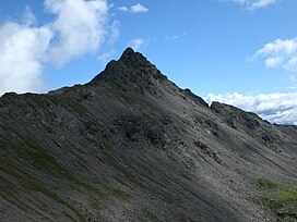
 The Tagewaldhorn (2.708 m) from SE above the innermost Flagger valley, Sarntal Alps, South Tyrol. The Tagewaldhorn (2.708 m) from SE above the innermost Flagger valley, Sarntal Alps, South Tyrol. | |
| Highest point | |
| Elevation | 2,708 m (8,885 ft) |
| Coordinates | 46°46′50″N 11°29′49″E / 46.78056°N 11.49694°E / 46.78056; 11.49694 |
| Geography | |
| Location | South Tyrol, Italy |
| Parent range | Sarntal Alps |
| Climbing | |
| First ascent | 12 July 1885 by Julius Pock |
The Tagewaldhorn (Italian: Corno di Tramin; German: Tagewaldhorn) is a mountain in the Sarntal Alps in South Tyrol, Italy.
References
- Hanspaul Menara: Südtiroler Gipfelwanderungen. Athesia, Bozen 2001, ISBN 88-8266-013-3
- 88-8315-054-6
- Topografische Wanderkarte, Monti Sarenti / Sarntaler Alpen, Blatt 040, 1:25.000, Casa Editrice Tobacco, ISBN 88-8315-054-6
This article about a mountain, mountain range, or peak located in Trentino-Alto Adige/Südtirol is a stub. You can help Misplaced Pages by expanding it. |