| Tangari | |
|---|---|
| Village | |
 | |
| Coordinates: 5°29′06″S 154°45′00″E / 5.48500°S 154.75000°E / -5.48500; 154.75000 | |
| Country | Republic of Bougainville |
| District | North Bougainville District |
| Local Level Government | Selau-Suir Rural LLG |
| Time zone | UTC+11 (BST) |
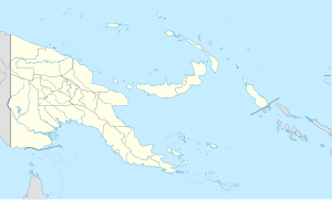
Tangari is a village in the Selau district of Bougainville, Papua New Guinea. It is located in north-western Bouganville near the Chabai Catholic mission.
It is one of the model villages covered by the Bougainville Healthy Community Programme (BHCP).
References
- "Bougainville Healthy Community Programme". Development_Policy_Centre. 2019-02-20. Retrieved 2019-02-20.
This Autonomous Region of Bougainville geography article is a stub. You can help Misplaced Pages by expanding it. |