| Telfes im Stubai | |
|---|---|
| Municipality | |
 | |
 Coat of arms Coat of arms | |
 | |
| Coordinates: 47°09′53″N 11°21′31″E / 47.16472°N 11.35861°E / 47.16472; 11.35861 | |
| Country | Austria |
| State | Tyrol |
| District | Innsbruck Land |
| Government | |
| • Mayor | Georg Viertler |
| Area | |
| • Total | 27.38 km (10.57 sq mi) |
| Elevation | 987 m (3,238 ft) |
| Population | |
| • Total | 1,570 |
| • Density | 57/km (150/sq mi) |
| Time zone | UTC+1 (CET) |
| • Summer (DST) | UTC+2 (CEST) |
| Postal code | 6165 |
| Area code | 05225 |
| Vehicle registration | IL |
| Website | www.gemeinde-telfes.at |
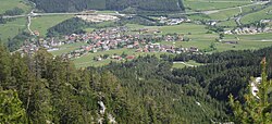
Telfes (officially Telfes im Stubai) is a village in the district Innsbruck Land in the Austrian state of Tyrol. It is situated in the Stubaital 11 km south of Innsbruck.

The municipality consists of the districts Telfes, Gagers, Kapfers, Plöven and Luimes. The area is about 27.83 km², and it is situated 987 m above sea level.
The coat of arms shows a lynx.
Neighbor villages
Axams, Birgitz, Fulpmes, Götzens, Grinzens, Mieders, Mutters, Neustift im Stubaital, Schönberg im Stubaital.
Population
| Year | Pop. | ±% |
|---|---|---|
| 1869 | 502 | — |
| 1880 | 468 | −6.8% |
| 1890 | 474 | +1.3% |
| 1900 | 444 | −6.3% |
| 1910 | 458 | +3.2% |
| 1923 | 506 | +10.5% |
| 1934 | 559 | +10.5% |
| 1939 | 552 | −1.3% |
| 1951 | 686 | +24.3% |
| 1961 | 649 | −5.4% |
| 1971 | 987 | +52.1% |
| 1981 | 1,069 | +8.3% |
| 1991 | 1,192 | +11.5% |
| 2001 | 1,369 | +14.8% |
| 2011 | 1,449 | +5.8% |
Geography
The village of Telfes is located in the front Stubaital, on the sunny left side of the Ruetz river. The municipality lies at an altitude of about 1000 m and has an area of 27.38 square kilometers. The hamlets Gerstbichl, Falschmair, Luimes, the scattered houses Telfer Wiesen and the single vineyards Wiesenhof and Gallhof (already above Schönberg) out of the valley belong to the municipality, as well as the Pfarrachalm at the Nederjoch, and the well-known hiking and skiing area Schlick below the Kalkkögel with the alpine inns Schlick (Schlickeralm) and Zirmach at the bottom of the valley, as well as Froneben and Sennjoch at the ridge (at Kreuzjoch only the cable car station).
History
The place name is derived from an Indo-Germanic language root "*tellevo", which means usable soil. The village was first mentioned in a document in 1133 as Telves. The population of Telfes is called Telfer (not Telfeser). The reason is the Rhaeto-Romanic origin of the place name. This ends with the Latin nominative ending -s, derivations are therefore formed without -s. This was the court seat for the Stubaital before it was moved to Mieders in 1690. The blacksmith's trade has been documented since 1541. Later on, iron production was added to the trade, which furthered the wealth of the village. Even today, numerous representations of iron producers on the old farms of the village bear witness to this tradition, which brought good fortune to the valley.
Personalities
- Andreas Kofler, Austrian ski jumper
Politics
- Present Mayor: Georg Viertler
- His deputy: Peter Lanthaler
References
- "Dauersiedlungsraum der Gemeinden Politischen Bezirke und Bundesländer - Gebietsstand 1.1.2018". Statistics Austria. Retrieved 10 March 2019.
- "Einwohnerzahl 1.1.2018 nach Gemeinden mit Status, Gebietsstand 1.1.2018". Statistics Austria. Retrieved 9 March 2019.