| Lordship of GroningenHeerlijkheid Groningen | |||||||
|---|---|---|---|---|---|---|---|
| 1536–1594 | |||||||
 | |||||||
| Capital | Groningen | ||||||
| Government | Heerlijkheid | ||||||
| History | |||||||
| • Battle of Heiligerlee | August 5, 1536 | ||||||
| • Established | 1536 | ||||||
| • Disestablished | 1594 | ||||||
| |||||||
| Today part of | Groningen | ||||||
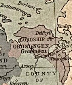
The Lordship of Groningen (Dutch: Heerlijkheid Groningen) was a lordship under the rule of the House of Habsburg between 1536 and 1594, which is the present-day province of Groningen.
Before 1536
A distinction must be made between the City of Groningen and the surrounding countryside, known as the Ommelanden. The city of Groningen had already gained its independence from its formal landlord, the Bishop of Utrecht in the 12th century. The Ommelanden, together with their Frisian neighbours, enjoyed the Frisian freedom and had never had a Lord. Therefore, before 1536, the concept of a Lord of Groningen had never existed.
Charles V
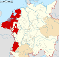
After the Habsburg victory in the Battle of Heiligerlee (1536) during the Guelders Wars, the city of Groningen and the Ommelanden came under the rule of Charles V, Holy Roman Emperor. They were joined in the Lordship of Groningen and ruled by a Stadtholder, but with preservation of their ancient rights and privileges. Because of the predominant position of the city, the union was never very successful. In 1548 the Lordship of Groningen became part of the Burgundian Circle.
Dutch rebellion
When the Union of Utrecht was signed in 1579, the Lordship of Groningen also joined. But there was much more enthusiasm in the Ommelanden, who saw this as an opportunity to regain their independence from the city, than in Groningen itself. In March 1580, Stadtholder George van Lalaing succeeded in convincing the city of Groningen to leave the Union of Utrecht and to remain loyal to the King of Spain. The city now became a northern bastion for the Spanish in the Eighty Years' War, but they lost more and more territory until the city was taken in the siege in 1594.
The lordship was abolished but the city and the Ommelanden remained united in one province. Groningen and the Ommelanden became part of the Republic of the Seven United Netherlands.
References
- ^ "GRONINGA in "Enciclopedia Italiana"". 2019-05-09. Archived from the original on 2019-05-09. Retrieved 2024-06-06.
- Vries, Oebele (2015-04-03). "Frisonica libertas : Frisian freedom as an instance of medieval liberty". Journal of Medieval History. 41 (2): 231. doi:10.1080/03044181.2015.1034162. ISSN 0304-4181.
- Henstra, Dirk (2000). "The Evolution of the Money Standard in Medieval Frisia: A Treatise on the History of the Systems of Money of Account in the Former Frisia (c.600-c.1500)" (PDF). Rijksuniversiteit Groningen. p. 85. Retrieved 7 June 2024.
- ^ Kamen, Henry (2014-03-26). Spain, 1469-1714: A Society of Conflict. Routledge. p. 68. ISBN 978-1-317-75500-5.
- "Genealogie in de Nederlanden". www.wazamar.org. Retrieved 2024-06-07.
- ^ "Groningen | Dutch Province, Cities & History | Britannica". www.britannica.com. 2024-05-06. Retrieved 2024-06-06.
- Blokker, Jan (2006). Waar is de Tachtigjarige Oorlog gebleven? (in Dutch) (1st ed.). De Harmonie. ISBN 978-90-6169-741-1.
- Israel, Jonathan (1995). The Dutch Republic: its rise, greatness and fall, 1477-1806. Oxford: Clarendon Press. pp. 246–50. ISBN 978-0-19-873072-9.
- Jaques, Tony (2007). Dictionary of battles and sieges: a guide to 8,500 battles from antiquity through the twenty-first century. Greenwood Press. p. 412. ISBN 978-0-313-33536-5. OCLC 68786744.
External links
 Media related to Lordship of Groningen at Wikimedia Commons
| Prince-bishops |  | ||||||
|---|---|---|---|---|---|---|---|
| Prince-abbots | |||||||
| Secular | |||||||
| Counts / Lords |
| ||||||
| Cities | |||||||
| from 1648 until 1648 without seat in Imperial Diet status uncertain
Circles est. 1500: Bavarian, Swabian, Upper Rhenish, Lower Rhenish–Westphalian, Franconian, (Lower) Saxon
| |||||||
| Seventeen Provinces of Habsburg Netherlands |
|  | ||||
|---|---|---|---|---|---|---|
| County | ||||||
| Cities | ||||||
| Dependent territories | ||||||
| until 1648; until 1659; until 1678.
Circles est. 1500: Bavarian, Swabian, Upper Rhenish, Lower Rhenish–Westphalian, Franconian, (Lower) Saxon Circles est. 1512: Austrian, Burgundian, Upper Saxon, Electoral Rhenish · Unencircled territories | ||||||
Categories: