| Litlkorsnestinden | |
|---|---|
| Trakta | |
 | |
| Highest point | |
| Elevation | 980 m (3,220 ft) |
| Coordinates | 68°20′11″N 14°53′03″E / 68.3364°N 14.8842°E / 68.3364; 14.8842 |
| Geography | |
| Interactive map of the mountain | |
| Location | Nordland, Norway |
| Parent range | Lofoten |
| Climbing | |
| First ascent | 3 August 1910: Bryn, Schjelderup and Rubenson. |
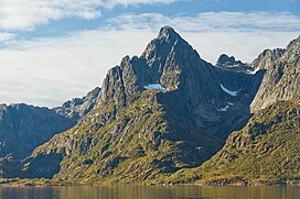
Litlkorsnestinden, (nicknamed: Trakta, lit. 'The Funnel') is a mountain in Hadsel Municipality in Nordland county, Norway. The 980-metre (3,220 ft) tall mountain lies on the island of Austvågøya in the Lofoten archipelago, just south of the Trollfjorden. The summit is the most difficult to reach in Norway; there is no trail for the long approach which is often extremely difficult terrain and the easiest route through the Northwest ridge is a mountaineer route graded 3N. It was first ascended in 1910 by Alf Bonnevie Bryn, Ferdinand Schjelderup and Carl Wilhelm Rubenson.
References
- ^ Webster, Ed (1994). Climbing in the Magic Islands. A climbing and hiking guidebook to the Lofoten Islands of Norway. Henningsvær: Nord Norsk Klatreskole. pp. 238–243.
- "Litlkorsnestinden, Hadsel (Nordland)" (in Norwegian). yr.no. Retrieved 17 June 2018.
- "Stadnamn og skrivemåten for stadnamn" (in Norwegian). Kartverket. Retrieved 20 December 2018.
This article about a mountain, mountain range, or peak in Nordland is a stub. You can help Misplaced Pages by expanding it. |