| This article needs additional citations for verification. Please help improve this article by adding citations to reliable sources. Unsourced material may be challenged and removed. Find sources: "Völklingen" – news · newspapers · books · scholar · JSTOR (December 2009) (Learn how and when to remove this message) |
| Völklingen | |
|---|---|
| Town | |
 | |
 Flag Flag Coat of arms Coat of arms | |
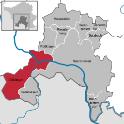
Location of Völklingen within Saarbrücken district
 | |
  | |
| Coordinates: 49°15′N 06°50′E / 49.250°N 6.833°E / 49.250; 6.833 | |
| Country | Germany |
| State | Saarland |
| District | Saarbrücken |
| Government | |
| • Mayor (2017–27) | Christiane Blatt (SPD) |
| Area | |
| • Total | 67.06 km (25.89 sq mi) |
| Elevation | 255 m (837 ft) |
| Population | |
| • Total | 40,192 |
| • Density | 600/km (1,600/sq mi) |
| Time zone | UTC+01:00 (CET) |
| • Summer (DST) | UTC+02:00 (CEST) |
| Postal codes | 66301–66333 |
| Dialling codes | 06898, 06802 |
| Vehicle registration | VK |
| Website | www |
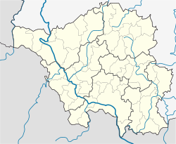
Völklingen (French: Vœlklange, Moselle Franconian: Välglinge) is a town in the district of Saarbrücken, in Saarland, Germany. It is situated on the river Saar, approx. 10 km west of Saarbrücken, and directly borders France.
The town is known for its industrial past, the Völklinger Hütte (ironworks) being declared by UNESCO as a World Heritage Site.
History
In antiquity it was settled by Celtic tribes, then by the Romans. The Franks settled in the area between the 5th and 9th centuries. Völkingen was initially referred to as "Fulcolingas" by Durandis, Vice Chancellor to Louis the Pious in 822.
Peasants living in the area were subject to taxation by the Count of Saarbrücken. The peasants of Völkingen revolted against the Count of Saarbrücken in 1566, when he ordered the construction of the Homburger castle.
Geography
Völklingen is situated on the fertile alluvial plane at the confluence of the river Rossel and of the river Köller into the river Saar.
Subdivisions
The town is divided into ten Stadtteile (quarters):
- Völkingen
- Fenne
- Fürstenhausen
- Geislautern
- Heidstock
- Lauterbach
- Ludweiler
- Luisenthal
- Röchlinghöhe
- Wehrden
Climate
Völklingen has an oceanic climate (Köppen: Cfb; Trewartha: Dobk).
| Climate data for Völklingen, 1961–1990 normals, extremes 1961–1982 | |||||||||||||
|---|---|---|---|---|---|---|---|---|---|---|---|---|---|
| Month | Jan | Feb | Mar | Apr | May | Jun | Jul | Aug | Sep | Oct | Nov | Dec | Year |
| Record high °C (°F) | 15.0 (59.0) |
17.5 (63.5) |
23.6 (74.5) |
29.0 (84.2) |
30.5 (86.9) |
33.2 (91.8) |
36.3 (97.3) |
34.5 (94.1) |
33.6 (92.5) |
27.4 (81.3) |
21.2 (70.2) |
16.1 (61.0) |
36.3 (97.3) |
| Mean maximum °C (°F) | 10.3 (50.5) |
12.4 (54.3) |
17.4 (63.3) |
23.2 (73.8) |
27.0 (80.6) |
29.6 (85.3) |
31.6 (88.9) |
31.2 (88.2) |
27.6 (81.7) |
22.7 (72.9) |
16.1 (61.0) |
11.9 (53.4) |
32.7 (90.9) |
| Mean daily maximum °C (°F) | 4.0 (39.2) |
6.6 (43.9) |
10.1 (50.2) |
14.3 (57.7) |
18.7 (65.7) |
22.0 (71.6) |
23.7 (74.7) |
23.4 (74.1) |
20.5 (68.9) |
14.9 (58.8) |
8.6 (47.5) |
4.6 (40.3) |
14.3 (57.7) |
| Daily mean °C (°F) | 1.5 (34.7) |
3.2 (37.8) |
6.0 (42.8) |
9.6 (49.3) |
13.7 (56.7) |
17.1 (62.8) |
18.6 (65.5) |
17.9 (64.2) |
14.9 (58.8) |
10.3 (50.5) |
5.6 (42.1) |
2.2 (36.0) |
10.0 (50.0) |
| Mean daily minimum °C (°F) | −0.9 (30.4) |
0.1 (32.2) |
2.1 (35.8) |
4.7 (40.5) |
8.2 (46.8) |
11.5 (52.7) |
12.9 (55.2) |
12.7 (54.9) |
10.0 (50.0) |
6.5 (43.7) |
2.9 (37.2) |
−0.3 (31.5) |
5.9 (42.6) |
| Mean minimum °C (°F) | −8.9 (16.0) |
−7.0 (19.4) |
−4.9 (23.2) |
−1.3 (29.7) |
1.7 (35.1) |
5.9 (42.6) |
7.5 (45.5) |
6.7 (44.1) |
4.3 (39.7) |
−0.1 (31.8) |
−4.1 (24.6) |
−8.5 (16.7) |
−11.5 (11.3) |
| Record low °C (°F) | −16.8 (1.8) |
−14.4 (6.1) |
−11.2 (11.8) |
−4.5 (23.9) |
−1.2 (29.8) |
2.6 (36.7) |
4.4 (39.9) |
4.8 (40.6) |
0.7 (33.3) |
−3.0 (26.6) |
−9.0 (15.8) |
−14.0 (6.8) |
−16.8 (1.8) |
| Average precipitation mm (inches) | 56.6 (2.23) |
51.1 (2.01) |
52.9 (2.08) |
47.0 (1.85) |
62.3 (2.45) |
64.4 (2.54) |
65.7 (2.59) |
62.6 (2.46) |
55.4 (2.18) |
52.4 (2.06) |
73.3 (2.89) |
68.8 (2.71) |
712.4 (28.05) |
| Average extreme snow depth cm (inches) | 5.6 (2.2) |
3.7 (1.5) |
2.4 (0.9) |
0.3 (0.1) |
0 (0) |
0 (0) |
0 (0) |
0 (0) |
0 (0) |
0 (0) |
1.8 (0.7) |
3.8 (1.5) |
9.8 (3.9) |
| Average precipitation days (≥ 0.1 mm) | 15.9 | 12.6 | 14.9 | 13.1 | 14.7 | 12.4 | 11.7 | 12.1 | 10.5 | 12.2 | 15.2 | 14.3 | 159.7 |
| Average relative humidity (%) | 83.5 | 79.0 | 73.9 | 68.6 | 66.3 | 67.1 | 67.2 | 70.6 | 75.1 | 80.0 | 82.2 | 83.1 | 74.7 |
| Source: Deutscher Wetterdienst/SKlima.de | |||||||||||||
Twin towns – sister cities
See also: List of twin towns and sister cities in GermanyVölklingen is twinned with:
 Ars-sur-Moselle, France
 Forbach, France
 Les Lilas, France
Notable people
- Johannes Schulz (1884–1942), catholic priest, died of hunger in Dachau concentration camp
- Hermann Neuberger (1919–1992), president of DFB
- Annegret Kramp-Karrenbauer (born 1962), politician (CDU)
- Daniel Sträßer (born 1987), actor
- Carrie Schreiner (born 1998), racing driver
Gallery

References
- Gewählte Ober-/Bürgermeister*innen, Landrät*innen und Regionalverbandsdirektor*in im Saarland, Statistisches Amt des Saarlandes, 27 March 2022.
- "Fläche und Bevölkerung - Stand: 31.12.2022 (Basis Zensus 2011)" (PDF) (in German). Statistisches Amt des Saarlandes. June 2023.
- "Völklingen Ironworks". UNESCO World Heritage Centre. United Nations Educational, Scientific, and Cultural Organization. Retrieved 26 June 2022.
- Die Stadtteile, Stadt Völkingen. Retrieved 3 November 2022.
- "Monatsauswertung". sklima.de (in German). SKlima. Retrieved 28 October 2024.
- "Städtepartnerschaften". voelklingen.de (in German). Völklingen. Retrieved 2021-02-22.
External links
- Official website
 (in German)
 - Historical facts about Völklingen (in German)
| Towns and municipalities in Saarbrücken (district) | ||
|---|---|---|
This Saarland location article is a stub. You can help Misplaced Pages by expanding it. |