County in Tennessee
| Washington County | |
|---|---|
| County | |
 Washington County Courthouse in Jonesborough Washington County Courthouse in Jonesborough | |
 Flag Flag Seal Seal | |
 Location within the U.S. state of Tennessee Location within the U.S. state of Tennessee | |
 Tennessee's location within the U.S. Tennessee's location within the U.S. | |
| Coordinates: 36°17′N 82°30′W / 36.29°N 82.5°W / 36.29; -82.5 | |
| Country | |
| State | |
| Founded | 1777 |
| Named for | George Washington |
| Seat | Jonesborough |
| Largest city | Johnson City |
| Area | |
| • Total | 330 sq mi (900 km) |
| • Land | 326 sq mi (840 km) |
| • Water | 3.3 sq mi (9 km) 1.0% |
| Population | |
| • Total | 133,001 |
| • Estimate | 138,420 |
| • Density | 400/sq mi (160/km) |
| Time zone | UTC−5 (Eastern) |
| • Summer (DST) | UTC−4 (EDT) |
| Congressional district | 1st |
| Website | www |
Washington County is a county located in the U.S. state of Tennessee. As of the 2020 census, the population was 133,001. Its county seat is Jonesborough. The county's largest city and a regional educational, medical and commercial center is Johnson City. Washington County is Tennessee's oldest county, having been established in 1777 when the state was still part of North Carolina. Washington County is part of the Johnson City, TN Metropolitan Statistical Area, which is a component of the Johnson City–Kingsport–Bristol, TN-VA Combined Statistical Area, commonly known as the "Tri-Cities" region.
History
Watauga and the Washington District
Washington County is rooted in the Watauga settlements, which were established in the early 1770s in the vicinity of what is now Elizabethton, in adjacent Carter County. At the outbreak of the Revolutionary War in 1776, the Wataugans organized the "Washington District", which was governed by a committee of safety. North Carolina initially refused to recognize the settlements as legal, but finally agreed to annex the district after the settlers thwarted an invasion by hostile Cherokees. The settlements were governed as the Washington District, which originally included all of what is now Tennessee. The district was reorganized as Washington County in 1777.
Washington County, North Carolina and Franklin
From 1777 until 1784, North Carolina held nominal control over the county, but did little for the residents, at least in their eyes. So the area citizens formed, in 1784, the State of Franklin to meet their needs. Franklin was an early attempt to create a fourteenth state prior to Kentucky and Vermont's admissions into the union. The county reverted to North Carolina control, however, following the failure of the Franklin state government in 1788.
Part of Tennessee
In 1790 the area became part of Southwest Territory, and afterward it was admitted to the Union in 1796 as the 16th state. Jonesboro, the county seat of Washington County, is Tennessee's oldest town. With many buildings restored, it comprises one of the nation's most authentic historic districts of the period 1790–1870.
Washington County was divided between pro-Union and pro-secession sentiments at the outset of the Civil War. In Tennessee's Ordinance of Secession referendum on June 8, 1861, Washington Countians voted 1,445 to 1,022 in favor of remaining in the Union. One of the bridges targeted by the East Tennessee bridge-burners in November 1861 was located in what is now Watauga near the Washington-Carter county line. Landon Carter Haynes, a Confederate senator, hailed from Washington County.
Johnson City, originally known as Johnson's Depot, was a major railway center for the southeastern states, connecting the region for freight transportation and passengers. It was the headquarters for both the standard-gauge Carolina, Clinchfield, and Ohio (Clinchfield Railroad), which required the excavation and blasting of 17 tunnels during its construction; and the narrow-gauge East Tennessee and Western North Carolina Railroad (Tweetsie). Significant restoration is underway, as well as publicizing the railroad heritage of the Johnson's Depot Historic District. Other historic properties are being restored as representative of Johnson City's late nineteenth and early twentieth-century era as a railway center.
Geography


According to the U.S. Census Bureau, the county has a total area of 330 square miles (850 km), of which 326 square miles (840 km) is land and 3.3 square miles (8.5 km) (1.0%) is water. The western portion of the county is situated in the Ridge-and-Valley Appalachians, which are characterized by long, narrow ridges roughly oriented northeast-to-southwest. The county's most prominent Ridge-and-Valley features rise in the vicinity of its northwestern border with Hawkins and Sullivan counties. The eastern portion of the county lies within the Blue Ridge Mountains, specifically the Bald Mountains (south of the Nolichucky River) and the Unaka Range (north of the Nolichucky). Buffalo Mountain, a long ridge that straddles much of Washington's eastern boundary, contains the county's highest point, 3,520-foot (1,070 m) Pinnacle Knob. The Cherokee National Forest protects much of the extreme eastern part of the county. Sampson Mountain, which rises in the southeastern part of the county, is home to a designated national wilderness area.
The Nolichucky River flows through the southern part of Washington County. The Watauga River flows the northern part of the county, and forms part of the county's border with Sullivan County. The lower section of the Watauga River is part of Boone Lake.
Adjacent counties
- Sullivan County (north)
- Carter County (east)
- Unicoi County (south)
- Greene County (west)
- Hawkins County (northwest)
National protected area
- Cherokee National Forest (part)
State protected areas
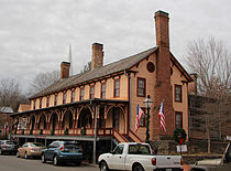
- Chester Inn (state historic site)
- Tipton-Haynes State Historic Site
Major highways
 I-26
I-26 I-81
I-81 US 11E
 US 19W
 US 23
US 23 US 321
 SR 36
SR 36 SR 67
SR 67 SR 75
SR 75 SR 81
SR 81 SR 91
SR 91 SR 93
SR 93 SR 107
 SR 353
 SR 354
 SR 381
 SR 400
Demographics
| Census | Pop. | Note | %± |
|---|---|---|---|
| 1790 | 5,872 | — | |
| 1800 | 6,379 | 8.6% | |
| 1810 | 7,740 | 21.3% | |
| 1820 | 9,557 | 23.5% | |
| 1830 | 10,995 | 15.0% | |
| 1840 | 11,751 | 6.9% | |
| 1850 | 13,861 | 18.0% | |
| 1860 | 14,829 | 7.0% | |
| 1870 | 16,317 | 10.0% | |
| 1880 | 16,181 | −0.8% | |
| 1890 | 20,354 | 25.8% | |
| 1900 | 22,604 | 11.1% | |
| 1910 | 28,968 | 28.2% | |
| 1920 | 34,052 | 17.6% | |
| 1930 | 45,805 | 34.5% | |
| 1940 | 51,631 | 12.7% | |
| 1950 | 59,971 | 16.2% | |
| 1960 | 64,832 | 8.1% | |
| 1970 | 73,924 | 14.0% | |
| 1980 | 88,755 | 20.1% | |
| 1990 | 92,315 | 4.0% | |
| 2000 | 107,198 | 16.1% | |
| 2010 | 122,979 | 14.7% | |
| 2020 | 133,001 | 8.1% | |
| 2023 (est.) | 138,420 | 4.1% | |
| U.S. Decennial Census 1790-1960 1900-1990 1990-2000 2010-2019, 2017 | |||

2020 census
| Race | Number | Percentage |
|---|---|---|
| White (non-Hispanic) | 112,606 | 84.67% |
| Black or African American (non-Hispanic) | 5,511 | 4.14% |
| Native American | 289 | 0.22% |
| Asian | 1,980 | 1.49% |
| Pacific Islander | 53 | 0.04% |
| Other/Mixed | 6,426 | 4.83% |
| Hispanic or Latino | 6,136 | 4.61% |
As of the 2020 United States census, there were 133,001 people, 55,817 households, and 33,838 families residing in the county.
2000 census
As of the census of 2000, there were 107,198 people, 44,195 households, and 29,478 families residing in the county. The population density was 328 people per square mile (127 people/km). There were 47,779 housing units at an average density of 146 units per square mile (56/km). The racial makeup of the county was 93.72% White, 3.82% Black or African American, 0.24% Native American, 0.73% Asian, 0.02% Pacific Islander, 0.51% from other races, and 0.97% from two or more races. 1.38% of the population were Hispanic or Latino of any race.
There were 44,195 households, out of which 28.20% had children under the age of 18 living with them, 52.60% were married couples living together, 10.50% had a female householder with no husband present, and 33.30% were non-families. 27.80% of all households were made up of individuals, and 9.70% had someone living alone who was 65 years of age or older. The average household size was 2.33 and the average family size was 2.85.
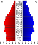
In the county, the population was spread out, with 21.30% under the age of 18, 10.80% from 18 to 24, 30.00% from 25 to 44, 24.00% from 45 to 64, and 13.90% who were 65 years of age or older. The median age was 37 years. For every 100 females, there were 94.80 males. For every 100 females age 18 and over, there were 91.70 males.
The median income for a household in the county was $33,116, and the median income for a family was $41,162. Males had a median income of $30,874 versus $21,485 for females. The per capita income for the county was $19,085. About 10.20% of families and 13.90% of the population were below the poverty line, including 16.80% of those under age 18 and 14.20% of those age 65 or over.
Education
There are two school districts in the county: Washington County School District and Johnson City School District. The majority of Johnson City is in the latter, while all other areas of the county are in the former.
Washington County schools include:
- Elementary schools
|
|
- Middle schools
- Boones Creek Middle School
- Jonesborough Middle School. Built in 1950 as a high school. Became a middle school in 1971. Has approximately 500 students in grades 5–8.
- High schools
- Asbury Optional High School
- Daniel Boone High School
- David Crockett High School
- Science Hill High School
- University School
Communities


Cities
- Johnson City (small portion in Carter County and Sullivan County)
- Watauga (mostly in Carter County)
Town
- Jonesborough (county seat)
Census-designated places
- Embreeville
- Fall Branch (partial)
- Gray
- Oak Grove
- Spurgeon (partial)
- Telford
Unincorporated communities
- Austin Springs
- Boone
- Boones Creek
- Bowmantown
- Bumpus Cove (partial)
- February
- Lamar
- Limestone
- Midway
- Mountain Home
- South Central
- Stewart Hill
- Sulphur Springs
- Washington College
Notable residents
| This section does not cite any sources. Please help improve this section by adding citations to reliable sources. Unsourced material may be challenged and removed. (September 2021) (Learn how and when to remove this message) |
- Joseph Hardin, Sr. – Revolutionary War hero, and North Carolina militia colonel for the Western Counties, 1788;
Politics
Like most of East Tennessee, Washington County has been a Republican stronghold since the Civil War. No National Democratic candidate has won the county since 1856, though Lyndon Johnson came within 359 votes of Barry Goldwater in 1964 and Jimmy Carter came within 819 votes of Gerald Ford in 1976. Franklin Roosevelt is the only other Democrat to even cross the 40 percent mark. The only time the Republicans have failed to win the county since 1868, the first election it competed in Tennessee, came in 1912, when the Bull Moose Party divided the Republican vote and won a plurality.
| Year | Republican / Whig | Democratic | Third party(ies) | |||
|---|---|---|---|---|---|---|
| No. | % | No. | % | No. | % | |
| 2024 | 42,299 | 69.08% | 18,131 | 29.61% | 804 | 1.31% |
| 2020 | 40,444 | 67.18% | 18,638 | 30.96% | 1,121 | 1.86% |
| 2016 | 34,252 | 68.85% | 13,024 | 26.18% | 2,474 | 4.97% |
| 2012 | 32,808 | 68.30% | 14,325 | 29.82% | 899 | 1.87% |
| 2008 | 32,341 | 66.03% | 15,941 | 32.54% | 700 | 1.43% |
| 2004 | 29,735 | 66.07% | 14,944 | 33.20% | 327 | 0.73% |
| 2000 | 22,579 | 59.51% | 14,769 | 38.93% | 594 | 1.57% |
| 1996 | 18,960 | 54.42% | 13,259 | 38.06% | 2,621 | 7.52% |
| 1992 | 18,206 | 51.31% | 13,071 | 36.84% | 4,206 | 11.85% |
| 1988 | 19,615 | 65.63% | 10,087 | 33.75% | 185 | 0.62% |
| 1984 | 21,762 | 69.38% | 9,452 | 30.13% | 154 | 0.49% |
| 1980 | 17,457 | 57.71% | 11,599 | 38.35% | 1,193 | 3.94% |
| 1976 | 14,770 | 50.87% | 13,951 | 48.05% | 311 | 1.07% |
| 1972 | 17,343 | 74.79% | 5,284 | 22.79% | 561 | 2.42% |
| 1968 | 12,882 | 56.66% | 4,930 | 21.68% | 4,925 | 21.66% |
| 1964 | 10,612 | 50.86% | 10,253 | 49.14% | 0 | 0.00% |
| 1960 | 14,851 | 69.93% | 6,283 | 29.59% | 102 | 0.48% |
| 1956 | 13,471 | 71.23% | 5,314 | 28.10% | 127 | 0.67% |
| 1952 | 12,023 | 69.31% | 5,245 | 30.24% | 79 | 0.46% |
| 1948 | 7,056 | 61.04% | 4,023 | 34.80% | 480 | 4.15% |
| 1944 | 6,485 | 61.17% | 4,060 | 38.29% | 57 | 0.54% |
| 1940 | 4,719 | 56.67% | 3,565 | 42.81% | 43 | 0.52% |
| 1936 | 4,788 | 51.52% | 4,448 | 47.86% | 58 | 0.62% |
| 1932 | 3,691 | 51.71% | 3,345 | 46.86% | 102 | 1.43% |
| 1928 | 4,887 | 76.00% | 1,543 | 24.00% | 0 | 0.00% |
| 1924 | 3,243 | 62.87% | 1,839 | 35.65% | 76 | 1.47% |
| 1920 | 4,858 | 68.21% | 2,260 | 31.73% | 4 | 0.06% |
| 1916 | 2,723 | 59.69% | 1,831 | 40.14% | 8 | 0.18% |
| 1912 | 1,134 | 26.58% | 1,531 | 35.89% | 1,601 | 37.53% |
| 1908 | 2,254 | 58.77% | 1,574 | 41.04% | 7 | 0.18% |
| 1904 | 2,120 | 61.63% | 1,268 | 36.86% | 52 | 1.51% |
| 1900 | 2,488 | 61.51% | 1,496 | 36.98% | 61 | 1.51% |
| 1896 | 2,807 | 61.98% | 1,661 | 36.67% | 61 | 1.35% |
| 1892 | 2,056 | 51.58% | 1,722 | 43.20% | 208 | 5.22% |
| 1888 | 2,008 | 55.13% | 1,534 | 42.12% | 100 | 2.75% |
| 1884 | 1,815 | 53.79% | 1,559 | 46.21% | 0 | 0.00% |
| 1880 | 2,104 | 57.17% | 1,576 | 42.83% | 0 | 0.00% |
| 1876 | 1,739 | 55.03% | 1,421 | 44.97% | 0 | 0.00% |
| 1872 | 1,458 | 63.53% | 837 | 36.47% | 0 | 0.00% |
| 1868 | 1,217 | 94.63% | 69 | 5.37% | 0 | 0.00% |
| 1860 | 0 | 0.00% | 62 | 2.63% | 2,298 | 97.37% |
| 1856 | 0 | 0.00% | 1,334 | 61.70% | 828 | 38.30% |
| 1852 | 565 | 39.84% | 853 | 60.16% | 0 | 0.00% |
| 1848 | 862 | 45.90% | 1,016 | 54.10% | 0 | 0.00% |
| 1844 | 881 | 41.83% | 1,225 | 58.17% | 0 | 0.00% |
| 1840 | 892 | 45.16% | 1,083 | 54.84% | 0 | 0.00% |
| 1836 | 439 | 36.61% | 760 | 63.39% | 0 | 0.00% |
| 1832 | 0 | 0.00% | 735 | 100.00% | 0 | 0.00% |
See also
References
- Origins Of Tennessee County Names, Tennessee Blue Book 2005-2006, pages 508-513
- ^ "State & County QuickFacts". United States Census Bureau. Retrieved December 7, 2013.
- "Find a County". National Association of Counties. Retrieved June 7, 2011.
- Washington County official website. Retrieved: November 15, 2013.
- ^ Mildred Kozsuch and Ruth Broyles, "Washington County", Tennessee Encyclopedia of History and Culture. Retrieved: November 15, 2013.
- Oliver Perry Temple, East Tennessee and the Civil War (R. Clarke Company, 1899), p. 199. Eric Lacy (Vanquished Volunteers, Appendix B) gives a much closer tally, 1,115 to 1,022.
- Temple, East Tennessee and the Civil War, pp. 384-385.
- "2010 Census Gazetteer Files". United States Census Bureau. August 22, 2012. Retrieved April 14, 2015.
- Tennessee Department of Environment and Conservation; et al. (July 1, 2010). "Ambient Air Monitoring Plan" (PDF). Environmental Protection Agency. Archived from the original (PDF) on April 2, 2015. Retrieved March 18, 2015.
- "Annual Estimates of the Resident Population for Counties: April 1, 2020 to July 1, 2023". United States Census Bureau. Retrieved March 14, 2024.
- "U.S. Decennial Census". United States Census Bureau. Retrieved April 14, 2015.
- "Historical Census Browser". University of Virginia Library. Retrieved April 14, 2015.
- Forstall, Richard L., ed. (March 27, 1995). "Population of Counties by Decennial Census: 1900 to 1990". United States Census Bureau. Retrieved April 14, 2015.
- "Census 2000 PHC-T-4. Ranking Tables for Counties: 1990 and 2000" (PDF). United States Census Bureau. April 2, 2001. Archived (PDF) from the original on October 9, 2022. Retrieved April 14, 2015.
- "QuickFacts. Washington County, Tennessee". United States Census Bureau. Retrieved October 2, 2018.
- Based on 2000 census data
- "Explore Census Data". data.census.gov. Retrieved December 26, 2021.
- "U.S. Census website". United States Census Bureau. Retrieved May 14, 2011.
- "2020 CENSUS - SCHOOL DISTRICT REFERENCE MAP: Washington County, TN" (PDF). U.S. Census Bureau. Retrieved October 8, 2024. - Text list
- "County Project (WIP)". Google Docs. Retrieved June 14, 2022.
- Leip, David. "Dave Leip's Atlas of U.S. Presidential Elections". uselectionatlas.org. Retrieved March 13, 2018.
External links
- Official site
- Washington County Schools Archived April 24, 2013, at the Wayback Machine
- Washington County TNGenWeb
| Places adjacent to Washington County, Tennessee | ||||||||||||||||
|---|---|---|---|---|---|---|---|---|---|---|---|---|---|---|---|---|
| ||||||||||||||||
| Municipalities and communities of Washington County, Tennessee, United States | ||
|---|---|---|
| County seat: Jonesborough | ||
| Cities | ||
| Town | ||
| CDPs | ||
| Other communities | ||
| Footnotes | ‡This populated place also has portions in an adjacent county or counties | |
| Free Republic of Franklin | |
|---|---|
| Jonesborough (capital) | |
| Topics | |
| Topographic Regions | |
| Geographic features | |
| Settlements | |
| The western counties of North Carolina | |
| Notable Franklinites | |
| Impediments |
|
36°17′N 82°30′W / 36.29°N 82.50°W / 36.29; -82.50
Categories: