| Revision as of 02:09, 26 July 2013 editSnoopywv (talk | contribs)130 edits →Photo gallery← Previous edit |
Latest revision as of 03:04, 23 October 2023 edit undoMitchazenia (talk | contribs)Autopatrolled, Administrators79,812 edits →Photo Gallery: adjust |
| (37 intermediate revisions by 25 users not shown) |
| Line 1: |
Line 1: |
|
{{Infobox Bridge |
|
{{Infobox bridge |
|
|bridge_name= Blennerhassett Island Bridge |
|
|name= Blennerhassett Island Bridge |
|
⚫ |
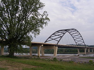
|image=File:Blennerhassett Bridge 033.jpg |
|
|image= |
|
|
|
|image_size=300px |
|
|caption= |
|
|caption= |
|
|official_name= |
|
|official_name= |
| Line 7: |
Line 8: |
|
|carries= 4 lanes of {{jct|country=USA|US|50}} |
|
|carries= 4 lanes of {{jct|country=USA|US|50}} |
|
|crosses= ] |
|
|crosses= ] |
|
|locale= ] and ] |
|
|locale= ] and ] |
|
|maint= ] |
|
|maint= ] |
|
|id= |
|
|id= |
|
|design= ] |
|
|design= ] |
|
|mainspan= <span style="white-space:nowrap">878 feet (268 m)</span> |
|
|mainspan= {{Nowrap|878 feet (268 m)}} |
|
|length= <span style="white-space:nowrap">4,009 feet (1,222 m)</span> |
|
|length= {{Nowrap|4,009 feet (1,222 m)}} |
|
|width= <span style="white-space:nowrap">107 feet (33 m)</span> |
|
|width= {{Nowrap|107 feet (33 m)}} |
|
|
|clearance_below= {{Nowrap|76 feet (23 m)}} |
|
|clearance= <span style="white-space:nowrap">76 feet (23 m)</span> |
|
|
|below= |
|
|below= |
|
|traffic= |
|
|traffic= |
| Line 20: |
Line 21: |
|
|closed= |
|
|closed= |
|
|toll= |
|
|toll= |
|
|map_cue= |
|
|
|map_image= |
|
|
|map_text= |
|
|
|map_width= |
|
|
|coordinates= {{coord|39|16|36|N|81|38|49|W|region:US_type:landmark|display=inline,title}} |
|
|coordinates= {{coord|39|16|36|N|81|38|49|W|region:US_type:landmark|display=inline,title}} |
|
|lat= |
|
|lat= |
| Line 29: |
Line 26: |
|
}} |
|
}} |
|
|
|
|
|
|
'''Blennerhassett Island Bridge''', with a ],<ref name="Delayed">{{cite web|author=Parkersburg News|title=Bridge Nears Completion|url=http://www.wvcorridord.com/media_20080412_bridgenears.htm|url-status=dead|archive-url=https://web.archive.org/web/20080513131413/http://www.wvcorridord.com/media_20080412_bridgenears.htm|archive-date=2008-05-13|access-date=2008-04-16}}</ref> carries ] (] ]) over the ] and the historic ] between ] and ] in the ]. Construction of the bridge was overseen by the Walsh Construction Company of ], and it opened to traffic on June 13, 2008. <ref name="Go Bridge">{{cite web|author=GoBridges.com|title=Innovative tied-arch steel bridge to span Ohio River|url=http://www.gobridges.com/article.asp?id=323|url-status=dead|archive-url=https://web.archive.org/web/20071007132032/http://www.gobridges.com/article.asp?id=323|archive-date=October 7, 2007|access-date=2015-12-08}}</ref> The completion of the span completed ] between ] east of ] to ] at ]. |
|
'''Blennerhassett Island Bridge''' opened to traffic June 13, 2008. The bridge is a ] constructed |
|
|
<ref name="Delayed">{{cite web|url=http://www.wvcorridord.com/media_20080412_bridgenears.htm|title=Bridge Nears Completion|author=Parkersburg News|accessdate=2008-04-16}}</ref> at a cost of $120 million over the ] between ] and ]. Construction of the bridge was completed by the Walsh Construction Company of ].<ref name="Go Bridge"/> |
|
|
|
|
|
|
⚫ |
==Photo gallery== |
|
The completion of the span, which carries ], completed ] between ] east of ] to ] at ]. Corridor D is a part of the ].<ref name="Go Bridge">{{cite web|url=http://www.gobridges.com/article.asp?id=323|title=Innovative tied-arch steel bridge to span Ohio River|author=GoBridges.com|accessdate=2005-05-28}}</ref> |
|
|
|
<gallery mode="packed" widths="180px" heights="120px"> |
|
|
|
|
⚫ |
File:Blennerhassett Bridge 032.jpg |
|
==Details== |
|
|
⚫ |
File:Blennerhassett Bridge 002.jpg |
|
The bridge travels over the ] and the historic ]. The bridge is wholly owned by ] while only the approach ramps on the Ohio side are owned by ] . |
|
|
⚫ |
File:Blennerhassett Bridge 038.jpg |
|
⚫ |
File:Blennerhassett Bridge 040.jpg |
|
|
File:Blennerhassett Bridge 026.jpg |
|
⚫ |
</gallery> |
|
|
|
|
|
==References== |
|
==References== |
| Line 41: |
Line 41: |
|
|
|
|
|
==External links== |
|
==External links== |
|
|
{{commons cat}} |
|
* at Bridges & Tunnels |
|
|
* at GoBridges |
|
* at Bridges & Tunnels |
|
|
* at GoBridges |
|
* at Gribblenation |
|
* at Gribblenation |
|
* |
|
* |
|
* |
|
* |
|
|
|
| ⚫ |
==Photo gallery== |
|
|
<gallery> |
|
| ⚫ |
File:Blennerhassett Bridge 032.jpg|Blennerhassett Bridge. |
|
| ⚫ |
File:Blennerhassett Bridge 002.jpg|Blennerhassett Bridge. |
|
| ⚫ |
File:Blennerhassett Bridge 033.jpg|Blennerhassett Bridge. |
|
| ⚫ |
File:Blennerhassett Bridge 038.jpg|Blennerhassett Bridge. |
|
| ⚫ |
File:Blennerhassett Bridge 040.jpg|Blennerhassett Bridge. |
|
| ⚫ |
</gallery> |
|
|
|
|
|
|
{{Crossings navbox |
|
{{Crossings navbox |
| Line 61: |
Line 53: |
|
|bridge = Blennerhassett Island Bridge |
|
|bridge = Blennerhassett Island Bridge |
|
|bridge signs = ] |
|
|bridge signs = ] |
|
|upstream = ] |
|
|upstream = ] |
|
|upstream signs = ] ] |
|
|upstream signs = ] ] |
|
|downstream = ] |
|
|downstream = ] |
| Line 67: |
Line 59: |
|
}} |
|
}} |
|
|
|
|
|
|
] |
|
] |
|
] |
|
] |
|
] |
|
] |
|
] |
|
] |
|
] |
|
] |
|
] |
|
|
] |
|
] |
|
] |
|
|
] |
|
] |
|
] |
|
] |
|
] |
|
] |
|
] |
|
|
] |
|
|
] |
|
|
] |
|
|
] |
|
|
|
|
|
|
|
|
|
{{WestVirginia-struct-stub}} |
|
{{WestVirginia-bridge-struct-stub}} |
|
{{US-bridge-struct-stub}} |
|


