| Revision as of 14:56, 18 February 2018 editLngnfltr (talk | contribs)344 editsmNo edit summary← Previous edit |
Latest revision as of 21:04, 6 January 2024 edit undoEbbedlila (talk | contribs)Extended confirmed users77,252 edits page movedTag: AWB |
| (14 intermediate revisions by 9 users not shown) |
| Line 1: |
Line 1: |
|
|
{{Use Canadian English|date=January 2023}} |
|
{{Infobox settlement |
|
{{Infobox settlement |
|
| name = Strong |
|
| name = Strong |
| Line 19: |
Line 20: |
|
| coordinates = {{coord|45|45|N|79|24|W|region:CA-ON|display=inline,title}} |
|
| coordinates = {{coord|45|45|N|79|24|W|region:CA-ON|display=inline,title}} |
|
| subdivision_type = Country |
|
| subdivision_type = Country |
|
| subdivision_name = {{CAN}} |
|
| subdivision_name = Canada |
|
| subdivision_type1 = Province |
|
| subdivision_type1 = ] |
|
| subdivision_name1 = {{ON}} |
|
| subdivision_name1 = ] |
|
| subdivision_type2 = District |
|
| subdivision_type2 = ] |
|
| subdivision_name2 = ] |
|
| subdivision_name2 = ] |
|
| established_title = Settled |
|
| established_title = Settled |
| Line 30: |
Line 31: |
|
| government_type = Township |
|
| government_type = Township |
|
| leader_title = Mayor |
|
| leader_title = Mayor |
|
| leader_name = Christine Ellis |
|
| leader_name = Tim Bryson |
|
| leader_title1 = Federal riding |
|
| leader_title1 = Federal riding |
|
| leader_name1 = ] |
|
| leader_name1 = ] |
|
| leader_title2 = Prov. riding |
|
| leader_title2 = Prov. riding |
|
| leader_name2 = ] |
|
| leader_name2 = ] |
|
| area_total_km2 = |
|
| area_total_km2 = |
|
| area_land_km2 = 159.93 |
|
| area_land_km2 = 158.88 |
|
| area_water_km2 = |
|
| area_water_km2 = |
|
| area_footnotes = <ref name=SC11/> |
|
| area_footnotes = <ref name="census2021"/> |
|
| population_as_of = 2016 |
|
| population_as_of = 2021 |
|
|
| population_footnotes = |
| ⚫ |
| population_footnotes = <ref name=SC11>Statistics Canada 2011 Census - </ref> |
|
|
| population_total = 1439 |
|
| population_total = 1566 |
|
| population_density_km2=9.0 |
|
| population_density_km2=9.9 |
|
| timezone = ] |
|
| timezone = ] |
|
| utc_offset = -5 |
|
| utc_offset = -5 |
| Line 49: |
Line 50: |
|
| postal_code_type = ] |
|
| postal_code_type = ] |
|
| postal_code = P0A |
|
| postal_code = P0A |
|
| area_code = ] |
|
| area_code = ], ] |
|
| elevation_footnotes = |
|
| elevation_footnotes = |
|
| elevation_m = |
|
| elevation_m = |
| Line 60: |
Line 61: |
|
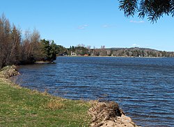
The township includes the communities of Hartfell, Kennedys, Lake Bernard, Pevensey, Stirling Falls and Strong. It surrounds ], which is claimed to be the world's largest freshwater lake without an ].<ref></ref> |
|
The township includes the communities of Hartfell, Kennedys, Lake Bernard, Pevensey, Stirling Falls and Strong. It surrounds ], which is claimed to be the world's largest freshwater lake without an ].<ref></ref> |
|
|
|
|
|
==Demographics== |
|
== Demographics == |
|
|
{{Historical populations |
|
Population trend:<ref>http://www12.statcan.gc.ca/census-recensement/2016/dp-pd/prof/details/page.cfm?Lang=E&Geo1=CSD&Code1=3549046&Geo2=CD&Code2=3549&Data=Count&SearchText=Strong&SearchType=Begins&SearchPR=01&B1=All&TABID=1</ref> |
|
|
|
|title = Strong Township historical populations |
|
* Population in 2016: 1439 (2011 to 2016 population change: 7.3%) |
|
|
|
|type = Canada |
|
* Population in 2011: 1341 |
|
|
|
|align = centre |
|
* Population in 2006: 1327 |
|
|
|
|percentages = |
|
* Population in 2001: 1369 |
|
|
|
|footnote =<ref>Statistics Canada: ], ], ], ], ], ]</ref><ref name=SC11/><ref name="census2016">{{cite web |url=http://www12.statcan.gc.ca/census-recensement/2016/dp-pd/prof/details/page.cfm?Lang=E&Geo1=CSD&Code1=3549046&Geo2=CD&Code2=3549&Data=Count&SearchText=Strong&SearchType=Begins&SearchPR=01&B1=All&TABID=1 |title=Census Profile, 2016 Census Strong, Township|date=8 February 2017 |publisher=Statistics Canada|accessdate=June 26, 2019}}</ref> |
|
* Population in 1996: 1393 |
|
|
* Population in 1991: 1377 |
|
|1991| 1377 |
|
|
|]| 1393 |
|
|
|]| 1369 |
|
|
|]| 1327 |
|
|
|]| 1341 |
|
|
|]| 1439 |
|
|
|]| 1566 |
|
|
}} |
|
|
|
|
|
|
In the ] conducted by ], Strong had a population of {{val|1566|fmt=commas}} living in {{val|660|fmt=commas}} of its {{val|953|fmt=commas}} total private dwellings, a change of {{percentage|{{#expr:1566-1439}}|1439|1}} from its 2016 population of {{val|1439|fmt=commas}}. With a land area of {{convert|158.88|km2|sqmi|abbr=on}}, it had a population density of {{Pop density|1566|158.88|km2|sqmi|prec=1}} in 2021.<ref name=2021census>{{cite web | url=https://www150.statcan.gc.ca/t1/tbl1/en/tv.action?pid=9810000203&geocode=A000235 | title=Population and dwelling counts: Canada, provinces and territories, census divisions and census subdivisions (municipalities), Ontario | publisher=] | date=February 9, 2022 | accessdate=April 2, 2022}}</ref> |
|
Private dwellings occupied by usual residents: 554 (total dwellings: 827) |
|
|
|
|
|
|
Mother tongue:<ref>{{cite web|url=http://www12.statcan.gc.ca/census-recensement/2006/dp-pd/prof/92-591/details/page.cfm?Lang=E&Geo1=CSD&Code1=3549046&Geo2=PR&Code2=35&Data=Count&SearchText=Strong&SearchType=Begins&SearchPR=01&B1=All&Custom=|title=2006 Strong community profile}}</ref> |
|
Mother tongue:<ref>{{cite web|url=http://www12.statcan.gc.ca/census-recensement/2006/dp-pd/prof/92-591/details/page.cfm?Lang=E&Geo1=CSD&Code1=3549046&Geo2=PR&Code2=35&Data=Count&SearchText=Strong&SearchType=Begins&SearchPR=01&B1=All&Custom=|title=2006 Strong community profile|date=13 March 2007 }}</ref> |
|
* English as first language: 95.1% |
|
* English as first language: 95.1% |
|
* French as first language: 1.5% |
|
* French as first language: 1.5% |
| Line 83: |
Line 91: |
|
|
|
|
|
==References== |
|
==References== |
|
{{reflist}} |
|
{{reflist|refs= |
|
|
<ref name="census2021">{{cite web |url=https://www12.statcan.gc.ca/census-recensement/2021/as-sa/fogs-spg/Page.cfm?Lang=E&Dguid=2021A00053549046&r=1 |title=Census Profile, 2021 Census Strong, Township|publisher=Statistics Canada|accessdate=February 9, 2022}}</ref> |
|
⚫ |
<ref name=SC11>Statistics Canada 2011 Census - </ref> |
|
|
}} |
|
|
|
|
|
==External links== |
|
==External links== |
|
* |
|
*{{official|http://www.strongtownship.com}} |
|
*, Almaguin Highlands Regional Portal |
|
|
|
|
|
|
{{Geographic location |
|
{{Geographic location |
The township includes the communities of Hartfell, Kennedys, Lake Bernard, Pevensey, Stirling Falls and Strong. It surrounds Lake Bernard, which is claimed to be the world's largest freshwater lake without an island.
 Lake Bernard in Strong Township

