| Revision as of 00:59, 27 May 2011 edit129.119.246.50 (talk) Both means -> The latter (Takeshima) means "bamboo island."← Previous edit | Latest revision as of 17:44, 20 October 2024 edit undoPueblo89 (talk | contribs)Extended confirmed users1,619 edits →Old Korean maps | ||
| (136 intermediate revisions by 77 users not shown) | |||
| Line 1: | Line 1: | ||
| {{Short description|South Korean island in the Sea of Japan}}{{Infobox island | |||
| ] | |||
| |name=Jukdo | |||
| ⚫ | |||
| ⚫ | |coordinates={{coord|37.529|N|130.938|E|source:kolossus-dewiki|display=title,inline}} | ||
| ⚫ | {{Infobox Korean name | ||
| |mapframe-zoom=13 | |||
| ⚫ | |module={{Infobox Korean name | ||
| |title=Korean name | |title=Korean name | ||
| |tablewidth=312 | |||
| |color=#e7dcc3 | |||
| |hangul=죽도 | |hangul=죽도 | ||
| |hanja=竹島 | |hanja={{linktext|竹|島}} | ||
| |rr=Jukdo | |rr=Jukdo | ||
| |mr=Chukto | |mr=Chukto | ||
| |child=yes | |||
| }} | }} | ||
| |image=Jukdo Island.png|image_caption=Satellite image of Jukdo (2020)}} | |||
| '''Jukdo''' is a small island adjacent to ], ]. It was formerly also known as ''Jukseodo'' (죽서도, 竹嶼島). It lies 2km east of Ulleungdo, and is the largest island in the group apart from Ulleungdo itself. In 2004, one family of three members were living on the island. Administratively, Jukdo belongs to Jeodong-ri, Ulleung township, ], ]. The ] used to write this island is ''Jukseodo'' ({{lang|ko|'''竹嶼'''島}}). | |||
| '''Jukdo''' ({{Korean|hangul=죽도|lit=bamboo island}}) is a small island in ], ], ], ], South Korea. It is next to the island ] in the ]. It is also known as '''Jukseodo''' ({{Korean|hangul=죽서도|hanja=竹嶼島|labels=no}}). It lies {{convert|2|km|0|abbr=on}} east of Ulleungdo, and is the largest island in the group apart from Ulleungdo itself. In 2004, one family of three members was living on the island. | |||
| Jukdo island measures {{convert|734|m|mi}} long and {{convert|482|m|mi}} wide. | |||
| The Chinese characters in Japanese for ], also known as Dokdo (독도, 獨島), is ''Takeshima'' ({{lang|ja|'''竹'''島}}). The latter means "bamboo island." | |||
| == Gallery == | |||
| <gallery widths="330" heights="220" perrow="3" caption="Ulleungdo/Jukdo"> | |||
| <!-- This is clear tag for layout --> | |||
| ⚫ | File:Ulleung island from above.jpg|Satellite view of Ulleungdo (North up). The small island to the northeast of Ulleungdo is Jukdo. | ||
| <div style="clear:left"></div> | |||
| File:Uleungdo Jukdo Liancourt Rocks.png|Positions of Uleungdo, Jukdo and Liancourt Rocks | |||
| </gallery> | |||
| === Old Korean maps === | |||
| <gallery widths="240px" heights="240px" perrow="4" caption=Ulleungdo, Jukdo, Usan> | |||
| file:八道総図.jpg|Joseon map (1530) | |||
| file:Ulleungdo and Usando.jpg|Joseon map (1530), close-up view of Jukdo | |||
| file:DaedongyeojidoUlleungdo.png|] "]" (1861) | |||
| file:East of Ulleungdo and Usando.jpg|Kim Jeong-ho "Daedongyeojido" (1861) | |||
| file:DaehanJeondo.jpg|A map by the ] (1899) | |||
| </gallery> | |||
| <!-- | <!-- | ||
| ==References== | ==References== | ||
| {{reflist|2}} | {{reflist|2}} | ||
| --> | --> | ||
| ==See also== | ==See also== | ||
| * ] | * ] | ||
| * ] | |||
| * ] | * ] | ||
| {{commons category|Jukdo Island}} | |||
| ⚫ | {{coord|37.529|N|130.938|E|source:kolossus-dewiki|display=title}} | ||
| ] | ] | ||
| ] | ] | ||
| ] | |||
| ⚫ | {{SouthKorea-geo-stub}} | ||
| ⚫ | {{SouthKorea-geo-stub}} | ||
| ] | |||
| ] | |||
| ] | |||
| ] | |||
| ] | |||
Latest revision as of 17:44, 20 October 2024
South Korean island in the Sea of Japan Satellite image of Jukdo (2020) Satellite image of Jukdo (2020) | |
| Geography | |
|---|---|
| Coordinates | 37°31′44″N 130°56′17″E / 37.529°N 130.938°E / 37.529; 130.938 |
| Korean name | |
| Hangul | 죽도 |
| Hanja | 竹島 |
| Revised Romanization | Jukdo |
| McCune–Reischauer | Chukto |
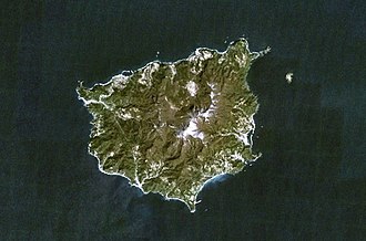
Jukdo (Korean: 죽도; lit. bamboo island) is a small island in Jeodong-ri, Ulleung-myeon, Ulleung County, North Gyeongsang Province, South Korea. It is next to the island Ulleungdo in the Sea of Japan. It is also known as Jukseodo (죽서도; 竹嶼島). It lies 2 km (1 mi) east of Ulleungdo, and is the largest island in the group apart from Ulleungdo itself. In 2004, one family of three members was living on the island.
Jukdo island measures 734 metres (0.456 mi) long and 482 metres (0.300 mi) wide.
Gallery
- Ulleungdo/Jukdo
-
 Satellite view of Ulleungdo (North up). The small island to the northeast of Ulleungdo is Jukdo.
-
 Positions of Uleungdo, Jukdo and Liancourt Rocks
Old Korean maps
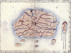
- Ulleungdo,
-
 Joseon map (1530)
-
 Joseon map (1530), close-up view of Jukdo
-
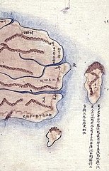
 Kim Jeong-ho "Daedongyeojido" (1861)
-
 Kim Jeong-ho "Daedongyeojido" (1861)
-
 A map by the Korean Empire (1899)
See also
This South Korea location article is a stub. You can help Misplaced Pages by expanding it. |