| Revision as of 01:03, 2 January 2015 edit77.49.7.215 (talk)No edit summary← Previous edit | Latest revision as of 11:57, 27 October 2024 edit undoMonkbot (talk | contribs)Bots3,695,952 editsm Task 20: replace {lang-??} templates with {langx|??} ‹See Tfd› (Replaced 1);Tag: AWB | ||
| (32 intermediate revisions by 19 users not shown) | |||
| Line 2: | Line 2: | ||
| |name = Lefkonas | |name = Lefkonas | ||
| |name_local = Λευκώνας | |name_local = Λευκώνας | ||
| |type = municipal unit | |||
| |image_map = |
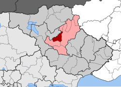
|image_map = DE Lefkona.svg | ||
| |map_caption = Location within the regional unit | |map_caption = Location within the regional unit | ||
| | periph = ] | | periph = ] | ||
| | periphunit = ] | | periphunit = ] | ||
| |municipality = ] | |municipality = ] | ||
| |pop_municunit = |
|pop_municunit = 3534 | ||
| |pop_community = 2221 | |||
| |population_as_of = |
|population_as_of = 2021 | ||
| |area = | |||
| |area_municunit = 68.2 | |||
| |elevation = | |elevation = | ||
| |coordinates = {{coord|41|06|N|23|29|E|format=dms|display=inline,title}} | |||
| |lat_deg = 41 | |||
| |lat_min = 06 | |||
| |lon_deg = 23 | |||
| |lon_min = 29 | |||
| |postal_code = | |postal_code = | ||
| |area_code = | |area_code = | ||
| |licence = ΕΡ | |licence = ΕΡ | ||
| |mayor = | |||
| |website = | |website = | ||
| }} | }} | ||
| '''Lefkonas''' ({{ |
'''Lefkonas''' ({{langx|el|Λευκώνας}}) is a village and a former municipality in the ], ]. Since the 2011 local government reform it is part of the municipality ], of which it is a municipal unit.<ref name=Kallikratis>{{Cite web|url=http://www.et.gr/idocs-nph/search/pdfViewerForm.html?args=5C7QrtC22wGYK2xFpSwMnXdtvSoClrL81-32jgAMSfbnMRVjyfnPUeJInJ48_97uHrMts-zFzeyCiBSQOpYnT00MHhcXFRTsb2fGphpq4MKX2ZkaHobySNnvZCNHXvYVvlf80XevW0Q.|title=ΦΕΚ B 1292/2010, Kallikratis reform municipalities|language=el|publisher=]}}</ref> The municipal unit has an area of 68.247 km<sup>2</sup>.<ref name=stat01>{{cite web|url=http://dlib.statistics.gr/Book/GRESYE_02_0101_00098%20.pdf |publisher=National Statistical Service of Greece |title=Population & housing census 2001 (incl. area and average elevation) |language=el |url-status=dead |archiveurl=https://web.archive.org/web/20150921212047/http://dlib.statistics.gr/Book/GRESYE_02_0101_00098%20.pdf |archivedate=2015-09-21 }}</ref> Population 3,534 (2021). | ||
| Near the village - on the hill of "Simitzi-bair" - the location of an ancient settlement has been found.<ref> Dimitrios C. Samsaris, A History of Serres (in the Ancient and Roman Times) (in Greek), Thessaloniki 1999, p. 164 (Website of Municipality of Serres)</ref> | |||
| It's cool people are always looking for new "pussy" (πούση), a local delicacy. Lefkonas Beach is the most well known beach in the region with people coming from around the world. It is also known for its good 'mavro' (μαύρο) and LADOman, a local hero, and his sidekick and friend Gosho (γκόσος). | |||
| ==Notable people== | |||
| *] | |||
| *] | |||
| *] | |||
| *] | |||
| == External links == | == External links == | ||
| * | * | ||
| ==See also== | |||
| ] | |||
| == References == | == References == | ||
| Line 32: | Line 39: | ||
| {{Serres div}} | {{Serres div}} | ||
| {{CentralMacedonia-geo-stub}} | |||
| ] | ] | ||
| ] | |||
| {{CentralMacedonia-geo-stub}} | {{CentralMacedonia-geo-stub}} | ||
| ] | |||
| ] | ] | ||
Latest revision as of 11:57, 27 October 2024
Municipal unit in Greece| Lefkonas Λευκώνας | |
|---|---|
| Municipal unit | |
  | |
| Coordinates: 41°06′N 23°29′E / 41.100°N 23.483°E / 41.100; 23.483 | |
| Country | Greece |
| Administrative region | Central Macedonia |
| Regional unit | Serres |
| Municipality | Serres |
| Area | |
| • Municipal unit | 68.2 km (26.3 sq mi) |
| Population | |
| • Municipal unit | 3,534 |
| • Municipal unit density | 52/km (130/sq mi) |
| • Community | 2,221 |
| Time zone | UTC+2 (EET) |
| • Summer (DST) | UTC+3 (EEST) |
| Vehicle registration | ΕΡ |
Lefkonas (Greek: Λευκώνας) is a village and a former municipality in the Serres regional unit, Greece. Since the 2011 local government reform it is part of the municipality Serres, of which it is a municipal unit. The municipal unit has an area of 68.247 km. Population 3,534 (2021).
Near the village - on the hill of "Simitzi-bair" - the location of an ancient settlement has been found.
Notable people
External links
See also
List of settlements in the Serres regional unit
References
- "Αποτελέσματα Απογραφής Πληθυσμού - Κατοικιών 2021, Μόνιμος Πληθυσμός κατά οικισμό" [Results of the 2021 Population - Housing Census, Permanent population by settlement] (in Greek). Hellenic Statistical Authority. 29 March 2024.
- "ΦΕΚ B 1292/2010, Kallikratis reform municipalities" (in Greek). Government Gazette.
- "Population & housing census 2001 (incl. area and average elevation)" (PDF) (in Greek). National Statistical Service of Greece. Archived from the original (PDF) on 2015-09-21.
- Dimitrios C. Samsaris, A History of Serres (in the Ancient and Roman Times) (in Greek), Thessaloniki 1999, p. 164 (Website of Municipality of Serres)
| Subdivisions of the municipality of Serres | |
|---|---|
| Municipal unit of Ano Vrontou | |
| Municipal unit of Kapetan Mitrousi |
|
| Municipal unit of Lefkonas |
|
| Municipal unit of Oreini | |
| Municipal unit of Serres |
|
| Municipal unit of Skoutari |
|
This Central Macedonia location article is a stub. You can help Misplaced Pages by expanding it. |