| Revision as of 08:02, 27 August 2007 view sourceAbecedare (talk | contribs)Autopatrolled, Administrators33,231 edits Revert to revision 153903884 dated 2007-08-27 07:17:54 by Abecedare using popups← Previous edit | Revision as of 08:05, 27 August 2007 view source Sarvagnya (talk | contribs)9,152 editsNo edit summaryNext edit → | ||
| Line 12: | Line 12: | ||
| | ] | | ] | ||
| |} | |} | ||
| '''Adam's Bridge''', popularly called '''Rama's Bridge''' or '''Rama Setu''' |
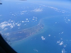
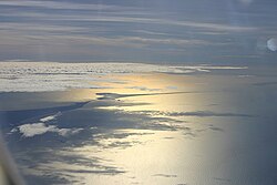
'''Adam's Bridge''', popularly called '''Rama's Bridge''' or '''Rama Setu''', is a chain of ] ]s, between the islands of Mannar, near northwestern ], and Rameswaram, off the southeastern coast of ]. The bridge is 30 miles (48 ]) long and separates the ] (southwest) from the ] (northeast). Some of the sandbanks are dry and the sea in the area is very shallow, being only 3 ft to 30 ft (1 ] to 10 m) deep. This seriously hinders navigation. It was reportedly passable on foot up to the ] until storms deepened the channel: temple records seem to say that Rama’s Bridge was complete above sea level until it broke in a ] in 1480 AD.{{Fact|date=March 2007}} | ||
| This landbridge once connected Sri Lanka to South India during the ]. | This landbridge once connected Sri Lanka to South India during the ]. | ||
Revision as of 08:05, 27 August 2007
9°07′16″N 79°31′18″E / 9.1210°N 79.5217°E / 9.1210; 79.5217
 |
 |
 |
 |
Adam's Bridge, popularly called Rama's Bridge or Rama Setu, is a chain of limestone shoals, between the islands of Mannar, near northwestern Sri Lanka, and Rameswaram, off the southeastern coast of India. The bridge is 30 miles (48 km) long and separates the Gulf of Mannar (southwest) from the Palk Strait (northeast). Some of the sandbanks are dry and the sea in the area is very shallow, being only 3 ft to 30 ft (1 m to 10 m) deep. This seriously hinders navigation. It was reportedly passable on foot up to the 15th century until storms deepened the channel: temple records seem to say that Rama’s Bridge was complete above sea level until it broke in a cyclone in 1480 AD. This landbridge once connected Sri Lanka to South India during the Wisconsin glaciation.
A ferry service linking the island and port of Rameswaram in India with Talaimannar in Sri Lanka has been suspended for some time because of the fighting between Sri Lankan government forces and the separatist LTTE.
The Pamban Bridge links Rameswaram island with mainland India.
History and Mythological beliefs
The name Rama's Bridge originates in Hindu belief. According to the Hindu epic Ramayana (Chapter 66, The Great Causeway ), the bridge was constructed at Rama's request by his allies. The bridge was supported on floating sand rocks but the gods were said to have later anchored the rocks to the sea bed, thus creating the present chain of rocky shoals. It was said to have helped Rama to reach Sri Lanka to rescue his wife Sita from the demon (Asura) king called Ravana, who was then the ruler of Lanka.
News services like the HindustanTimes (Press Trust of India), Vaishnava News Network and Indolink claimed that the bridge is evidence that events narrated in the Ramayana epic actually took place. Besides NASA's imagery, they cite several geological evidence as proof of their claims. However, NASA has distanced itself from the claims related to the epic Ramayana: "The images may be ours, but their interpretation is certainly not ours. Remote sensing images or photographs from orbit cannot provide direct information about the origin or age of a chain of islands, and certainly cannot determine whether humans were involved in producing any of the patterns seen." They state there is no evidence of the "bridge" being anything but a natural series of sandbanks, and noted there is no evidence of human presence in the Indian subcontinent more than 350,000 years ago.
Various estimates were made regarding the age of the bridge and the method of formation by Hindu archeologists and geologists and a team from CRS (Center for Remote Sensing):
- Rama’s bridge could only be 3,500 years old according to the Centre for Remote Sensing (CRS) of Bharathidasan University in Tiruchi -
- Rama Setu is NOT a natural formation: Dr. Badrinarayanan, former director of Geological Survey of India and a member of the National Institute of Ocean Technology (NIOT) says the Rama's Bridge was not a natural formation.
- The Hindu also published a report (quoting N. Ramanujam, Head, Post Graduate Department of Geology and Research Centre, V.O. Chidambaram College) saying that Rama's Bridge is a natural phenomenon and not a man-made one.
- Rama Setu IS a natural formation: American space agency NASA has said that the structure of sand bars and rocks situated in the Palk Strait between India and Sri Lanka, known as Ram Sethu or Adam's Bridge in maps, is a natural phenomenon and not a man-made structure. This was announced on Saturday by N K Raghupathy, CEO, Sethusamudram Corp Ltd, at a press conference when he revealed the contents of an email received in this regard from NASA's Johnson Space Centre. A few days back, the company sent an email to NASA to know whether Ram Sethu was a man-made structure."
Infrastructure development
Recently the Government of India has approved a multi-million dollar Sethusamudram Shipping Canal Project that aims to create a ship channel across the Palk Strait. The plan is to dredge the shallow ocean floor near the Dhanushkodi end of Rama's Bridge to create enough leeway allowing ships to pass through the channel instead of having to go around the island of Sri Lanka. It is expected to save nearly 30 hours' shipping time by cutting over 400 km off the voyage. However, efforts to conserve the heritage of the bridge has been initiated under the Ram Karmabhoomi movement; and there is fear that the large amount of dredging needed would damage coral reefs in the area, directly and by stirring up sediment. World Monuments Fund has recommended that the Government of India send scuba divers underwater to collect sand deposits from the bridge and analyse them in the laboratory.
See also
External links
- The Ram Karmabhoomi Issue
- Sethusamudram Ship Canal Project
- Adam's Bridge in Google Maps
- Significance of Rama Setu in Skanda Purana
- US heritage body wants Ram Sethu preserved
References
- NASA images find 1,750,000 year old man-made bridge, rense.com
- NASA's Rebuttal: A Bridge too far, trekshare.com
- NASA images discover ancient bridge between India & Sri Lanka, vnn.org
- NASA images discover ancient bridge between India & Sri Lanka, indolink.com
- NASA debunks Rama bridge theory, laputanlogic.com
- "Ramasamy explains that the land/beaches were formed between Ramanathapuram and Pamban because of the long shore drifting currents which moved in an anti-clockwise direction in the north and clockwise direction in the south of Rameswaram and Talaimannar about 3,500 years ago. ... But as the carbon dating of the beaches roughly matches the dates of Ramayana, its link to the epic needs to be explored, he adds."
- "Such a natural formation is impossible. Unless somebody has transported them and dumped them there, those reefs could not have come there. Some boulders were so light that they could float on water."
- It's not a man-made structure, hindu.com