| Revision as of 20:46, 7 October 2009 editPolaron (talk | contribs)Autopatrolled, Extended confirmed users44,831 edits relationship with included historic district← Previous edit | Revision as of 01:15, 8 October 2009 edit undoDoncram (talk | contribs)203,830 edits remove possibly true, but unsourced, assertionNext edit → | ||
| Line 30: | Line 30: | ||
| The ] also preserves the ], owned at one time by ] immigrants Neil and Emma Erickson.{{cn|date=June 2009}} | The ] also preserves the ], owned at one time by ] immigrants Neil and Emma Erickson.{{cn|date=June 2009}} | ||
| In 2008, the ], |
In 2008, the ], which presumably includes part of the National Monument, was listed on the ].<ref name="nris">{{cite web|url=http://www.nr.nps.gov/|title=National Register Information System|date=2009-03-13|work=National Register of Historic Places|publisher=National Park Service}}</ref> | ||
| ==Gallery== | ==Gallery== | ||
Revision as of 01:15, 8 October 2009
| Chiricahua National Monument | |
|---|---|
| IUCN category III (natural monument or feature) | |
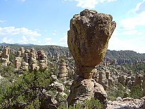
 The Balanced Rock formation The Balanced Rock formation | |
| Lua error in Module:Location_map at line 526: Unable to find the specified location map definition: "Module:Location map/data/US_Locator_Blank.svg" does not exist. | |
| Location | Cochise County, Arizona, USA |
| Nearest city | Willcox, AZ |
| Area | 12,000 acres (49 km²) |
| Established | April 18, 1924 |
| Governing body | National Park Service |
Chiricahua National Monument is a unit of the National Park Service. The monument is located approximately 36 miles (58 km) southeast of Willcox, Arizona. It preserves the remains of an immense volcanic eruption that shook the region some 27 million years ago. Called the Turkey Creek Caldera eruption, it eventually laid down two thousand feet of ash and pumice, highly siliceous in nature. This eventually hardened into rhyolite tuffs, and eroded into the natural features visible at the monument today.
The National Monument was designated on April 18, 1924. The national monument also preserves the Faraway Ranch, owned at one time by Swedish immigrants Neil and Emma Erickson.
In 2008, the Chiricahua National Monument Historic Designed Landscape, which presumably includes part of the National Monument, was listed on the National Register of Historic Places.
Gallery
-
 Stone columns are the most common formation in the monument.
-
 180° Panoramic view captured in High dynamic range imaging atop the Chiricahua National Monument.
References
- "National Register Information System". National Register of Historic Places. National Park Service. 2009-03-13.
External links
| U.S. National Register of Historic Places | |
|---|---|
| Topics | |
| Lists by state |
|
| Lists by insular areas | |
| Lists by associated state | |
| Other areas | |
| Related | |
This Arizona state location article is a stub. You can help Misplaced Pages by expanding it. |
This article related to a protected area in the United States is a stub. You can help Misplaced Pages by expanding it. |