| Revision as of 13:49, 28 January 2015 edit98.209.25.54 (talk) Changed de facto to de jure because under Israeli law, the referenced territory has been annexed.← Previous edit | Revision as of 02:28, 29 January 2015 edit undoSupreme Deliciousness (talk | contribs)Extended confirmed users, Pending changes reviewers, Rollbackers22,574 edits Cant be "de jure" as its illegal.Next edit → | ||
| Line 26: | Line 26: | ||
| The '''Northern District''' ({{lang-he|מחוז הצפון}}, ''Mehoz Hatzafon''; {{lang-ar|منطقة الشمال}}, ''Minţaqah ash-Shamal'') is one of ]'s ]. The Northern District has a land area of 4,478 km², which increases to 4,638 km² when both land and water are included. The district capital and largest city in the North District is ]. | The '''Northern District''' ({{lang-he|מחוז הצפון}}, ''Mehoz Hatzafon''; {{lang-ar|منطقة الشمال}}, ''Minţaqah ash-Shamal'') is one of ]'s ]. The Northern District has a land area of 4,478 km², which increases to 4,638 km² when both land and water are included. The district capital and largest city in the North District is ]. | ||
| The Golan Heights has been run as a sub-district of the North District of Israel since the 1981 ] was passed, although its |
The Golan Heights has been run as a sub-district of the North District of Israel since the 1981 ] was passed, although its proclaimed annexation is not internationally recognized, and the unenforced ] declared the annexation invalid. Excluding the ], which is 1,154 km² in area, the land total comes to 3,324 km² (3,484 km² including water). | ||
| ==Demographics== | ==Demographics== | ||
Revision as of 02:28, 29 January 2015
Place| North District | |
|---|---|
| - transcription(s) | |
| • Hebrew | Template:Hebrew |
| • Arabic | منطقة الشمال |
 | |
| Cities | 17 |
| Local Councils | 61 |
| Regional Councils | 15 |
| Capital | Nazareth |
| Area | |
| • Total | 4,478 km (1,729 sq mi) |
| Population | |
| • Total | 1,304,600 |
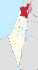
The Northern District (Template:Lang-he, Mehoz Hatzafon; Template:Lang-ar, Minţaqah ash-Shamal) is one of Israel's six administrative districts. The Northern District has a land area of 4,478 km², which increases to 4,638 km² when both land and water are included. The district capital and largest city in the North District is Nazareth.
The Golan Heights has been run as a sub-district of the North District of Israel since the 1981 Golan Heights Law was passed, although its proclaimed annexation is not internationally recognized, and the unenforced United Nations Security Council Resolution 497 declared the annexation invalid. Excluding the Golan Heights, which is 1,154 km² in area, the land total comes to 3,324 km² (3,484 km² including water).
Demographics
According to the Israeli Central Bureau of Statistics data for 2011:
- Total population: 1,304,600 (2011)
- Ethnic :
- Religious :
- Jews: 572,600 (43.9%)
- Muslims: 498,700 (38.2%)
- Druze: 104,500 (8%)
- Christians: 92,800 (7.1%)
- Not classified: 34,400 (2.6%)
- Density: 261/km²
As such, the North District is the only district in Israel where the majority of inhabitants are Arabs.
Administrative regions
Subdistricts
The Northern District is divided into the following subdistricts:
- Safed Subdistrict
- Kineret Subdistrict
- Jezreel Subdistrict
- Acre Subdistrict
- Ramat HaGolan Subdistrict
Municipalities
| Cities | Local Councils | Regional Councils |
|---|---|---|
See also
References
| Districts of Israel | |
|---|---|
32°50′N 35°20′E / 32.833°N 35.333°E / 32.833; 35.333
This geography of Israel article is a stub. You can help Misplaced Pages by expanding it. |
