| Revision as of 00:48, 1 April 2022 editDušan Kreheľ (bot) (talk | contribs)7,016 edits Infobox.← Previous edit | Latest revision as of 22:15, 18 November 2024 edit undoEnzoTC (talk | contribs)Extended confirmed users2,067 editsm Updated infobox | ||
| (6 intermediate revisions by 5 users not shown) | |||
| Line 1: | Line 1: | ||
| {{Infobox settlement | {{Infobox settlement | ||
| | name |
| name = Špania Dolina | ||
| | |
| other_name = Úrvölgy | ||
| | |
| settlement_type = ] | ||
| <!-- images, nickname, motto --> | |||
| | settlement_type = Village | |||
| | image_skyline = Spania Dolina 2007 11.jpg | |||
| | image_caption |
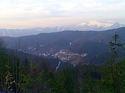
| image_caption = Špania Dolina from Panský Diel | ||
| | image_flag |
| image_flag = Spania dolina-banska bystrica-flag.svg | ||
| | image_shield |
| image_shield = Špania Dolina CoA.svg | ||
| <!-- location --> | |||
| | motto = | |||
| | |
| subdivision_type = ] | ||
| | |
| subdivision_name = {{SVK}} | ||
| | |
| subdivision_type1 = ] | ||
| | subdivision_name1 = {{flag|Banská Bystrica Region}} | |||
| | subdivision_name = Slovakia | |||
| ⚫ | | subdivision_type2 = ] | ||
| | subdivision_type1 = | |||
| | |
| subdivision_name2 = ] | ||
| ⚫ | <!-- maps and coordinates --> | ||
| ⚫ | | subdivision_type2 |
||
| | |
| pushpin_map = Slovakia Banská Bystrica Region#Slovakia | ||
| | |
| pushpin_relief = 1 | ||
| | |
| pushpin_map_caption = Location of Špania Dolina in the ]##Location of Špania Dolina in ] | ||
| ⚫ | | coordinates = {{coord|48.82|N|19.13|E|region:SK|display=inline,title}} | ||
| | subdivision_type4 = | |||
| <!-- government --> | |||
| ⚫ | |||
| | |
| leader_title = Mayor | ||
| | |
| leader_name = Martina Wilhelmerová | ||
| | |
| leader_party = | ||
| <!-- established --> | |||
| | pushpin_relief = 1 | |||
| ⚫ | | established_title = First mentioned | ||
| | pushpin_map_caption = Location of Špania Dolina in the ] | |||
| ⚫ | | established_date = 1263 | ||
| ⚫ | | coordinates |
||
| <!-- area --> | |||
| | coordinates_footnotes = <!-- government type, leaders --> | |||
| ⚫ | | area_footnotes = <ref name="area">{{Cite web |url=http://datacube.statistics.sk/#!/view/sk/VBD_DEM/om7014rr/v_om7014rr_00_00_00_sk |title=Hustota obyvateľstva - obce |language=sk |date=2022-03-31 |website=www.statistics.sk |publisher= Statistical Office of the Slovak Republic|access-date=2022-03-31}}</ref> | ||
| | leader_title = Mayor | |||
| | |
| area_total_km2 = 12.72 | ||
| <!-- elevation --> | |||
| ⚫ | |||
| ⚫ | | elevation_footnotes = <ref name="base_info">{{Cite web |url=http://datacube.statistics.sk/#!/view/sk/VBD_SK_WIN/om5001rr/v_om5001rr_00_00_00_sk |title=Základná charakteristika |language=sk |date=2015-04-17 |website=www.statistics.sk |publisher= Statistical Office of the Slovak Republic|access-date=2022-03-31}}</ref> | ||
| ⚫ | | established_date |
||
| | elevation_m = 711 | |||
| <!-- population --> | |||
| ⚫ | | |
||
| ⚫ | | population_as_of = {{abbr|2021|Population: 2021-12-31. Population density & Total area: 2021-06-30/-07-01. Elevation, Postal code & Area code (last updated): 2015-04-17.}} | ||
| | area_total_sq_mi = 4.91<ref name="area"/> | |||
| ⚫ | | population_footnotes = <ref>{{Cite web |url=http://datacube.statistics.sk/#!/view/sk/VBD_DEM/om7101rr/v_om7101rr_00_00_00_sk |title=Počet obyvateľov podľa pohlavia - obce (ročne) |language=sk |date=2022-03-31 |website=www.statistics.sk |publisher= Statistical Office of the Slovak Republic|access-date=2022-03-31}}</ref> | ||
| | area_land_sq_mi = | |||
| | |
| population_total = 226 | ||
| <!-- time zone(s) --> | |||
| | elevation_footnotes = | |||
| | timezone1 = ] | |||
| ⚫ | | |
||
| | |
| utc_offset1 = +1 | ||
| ⚫ | | timezone1_DST = ] | ||
| ⚫ | | population_as_of |
||
| | |
| utc_offset1_DST = +2 | ||
| <!-- postal codes, area code --> | |||
| ⚫ | | |
||
| ⚫ | | postal_code_type = Postal code | ||
| | population_density_km2 = 17.49<ref name="pd">{{Cite web |url=http://datacube.statistics.sk/#!/view/sk/VBD_DEM/om7014rr/v_om7014rr_00_00_00_sk |title=Hustota obyvateľstva - obce |language=sk |date=2022-03-31 |website=www.statistics.sk |publisher= Statistical Office of the Slovak Republic|access-date=2022-03-31}}</ref> | |||
| | |
| postal_code = 974 15<ref name="base_info"/> | ||
| | |
| area_code = +421 48<ref name="base_info"/> | ||
| | |
| blank_name = ] | ||
| | |
| blank_info = BB | ||
| <!-- website, footnotes --> | |||
| ⚫ | | timezone1_DST |
||
| | |
| website = {{URL|https://www.spaniadolina.sk/}} | ||
| ⚫ | | postal_code_type |
||
| | postal_code = 974 15<ref name="base_info"/> | |||
| | area_code_type = | |||
| | area_code = +421 48<ref name="base_info"/> | |||
| | geocode = | |||
| | iso_code = | |||
| | blank_name = ] | |||
| | blank_info = BB | |||
| <!-- website, footnotes -->| website = | |||
| | footnotes = | |||
| | official_name = | |||
| }} | }} | ||
| '''Špania Dolina''' is a village and municipality in central ], near the city of ].<ref>{{Cite web|url=https://www.e-obce.sk/obec/spaniadolina/spania-dolina.html|title=Špania Dolina - Okres Banská Bystrica - E-OBCE.sk|website=www.e-obce.sk|accessdate=Sep 29, 2020}}</ref> Although its permanent population does not exceed 200 people, it is a picturesque historic village situated 728 m above sea level and is surrounded by the ] and ] mountains. It has become a popular tourist recreation centre. | '''Špania Dolina''' ({{langx|hu|Úrvölgy}}) is a village and municipality in central ], near the city of ].<ref>{{Cite web|url=https://www.e-obce.sk/obec/spaniadolina/spania-dolina.html|title=Špania Dolina - Okres Banská Bystrica - E-OBCE.sk|website=www.e-obce.sk|accessdate=Sep 29, 2020}}</ref> Although its permanent population does not exceed 200 people, it is a picturesque historic village situated 728 m above sea level and is surrounded by the ] and ] mountains. It has become a popular tourist recreation centre. | ||
| ==Name== | ==Name== | ||
| Line 85: | Line 74: | ||
| ==References== | ==References== | ||
| {{reflist}} | {{reflist}} | ||
| ==External links== | |||
| *{{commonscatinline}} | |||
| *{{Official|http://www.spaniadolina.sk/ }} | |||
| {{Banska Bystrica District}} | {{Banska Bystrica District}} | ||
| Line 96: | Line 81: | ||
| {{DEFAULTSORT:Spania Dolina}} | {{DEFAULTSORT:Spania Dolina}} | ||
| ] | ] | ||
| ] | |||
Latest revision as of 22:15, 18 November 2024
Municipality in Banská Bystrica Region, Slovakia| Špania Dolina Úrvölgy | |
|---|---|
| Municipality | |
 Špania Dolina from Panský Diel Špania Dolina from Panský Diel | |
 Flag Flag Coat of arms Coat of arms | |
  | |
| Coordinates: 48°49′N 19°08′E / 48.82°N 19.13°E / 48.82; 19.13 | |
| Country | |
| Region | |
| District | Banská Bystrica District |
| First mentioned | 1263 |
| Government | |
| • Mayor | Martina Wilhelmerová |
| Area | |
| • Total | 12.72 km (4.91 sq mi) |
| Elevation | 711 m (2,333 ft) |
| Population | |
| • Total | 226 |
| Time zone | UTC+1 (CET) |
| • Summer (DST) | UTC+2 (CEST) |
| Postal code | 974 15 |
| Area code | +421 48 |
| Car plate | BB |
| Website | www |
Špania Dolina (Hungarian: Úrvölgy) is a village and municipality in central Slovakia, near the city of Banská Bystrica. Although its permanent population does not exceed 200 people, it is a picturesque historic village situated 728 m above sea level and is surrounded by the Staré Hory and Veľká Fatra mountains. It has become a popular tourist recreation centre.
Name
The ancient Latin name of the village is Valis Dominorum (meaning "Lord’s Valley"). The first part of the Slovak name ("Špania") is derived from another Latin word for "lord": spanatus. The second part ("Dolina") means "valley" in Slovak. The old German name of the village was Herrengrundt and it has been used for centuries by Carpathian Germans living in the area. The Hungarian name of the village is Úrvölgy.
History


Prehistoric mining tools excavated in the territory of Špania Dolina have been dated from as early as 2000-1700 BC. Copper from Špania Dolina has also been identified in bronze artifacts from the Balkans and the Middle East. It indicates that the local mines were part of an extensive network of trade routes during the Bronze Age. However, the first written reference to the village itself only appeared in 1254. Abundant deposits of copper and silver were exploited first by miners from Banská Bystrica and after 1494 by one of the first multinational corporations, founded by the affluent Fugger and Thurzo families.
The rich region attracted many foreign visitors. The House of Fugger funded a laboratory of the famous alchemist Paracelsus there. In 1696, Edward Browne gave description of the mine of Herrengrund (Browne used the German name of the settlement), belonged that time to the Hungarian Kingdom, in his book: Brief account of some travels in Hungaria, Servia, Bulgaria, Macedonia, Thessaly, Austria, Styria, Carinthia, and Friuli. He mentions the very rich ore, „in an hundred ponds of Ore they ordinarily find twenty ponds of Copper”. Browne sent some ore to the prominent English naturalist, John Woodward, these are now in his collection in Sedgwick Museum of Earth Sciences, Cambridge. The prominent French thinker Montesquieu visited and described the copper mines in Špania Dolina upon the encouragement of Isaac Newton.
The ancient tradition of making bobbin lace led to the establishment of a bobbin lace craft school in 1883. The copper mines were closed down in 1888 and the economy of the village is now based primarily on tourism.
Landmarks
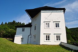
A covered stairway leads to a fortified church, built in the Gothic and Renaissance styles. Wooden miners' houses, now reconstructed, were originally built in the 17th and 18th centuries. The so-called "Knocker" from the 16th century served as a special bell tower for calling the miners to work in the morning. Ancient shafts and other technical monuments are scattered in the nearby forests. Špania Dolina is also a hub of hiking, mountain biking, and cross-country skiing trails.
Demographics
Špania Dolina has only 192 residents (as of December 31, 2013). According to the 2001 census, 95.3% of inhabitants were Slovaks and 3% Czechs. The religious makeup was 82.8% Roman Catholics and 10.7% people with no religious affiliation.
References
- "Hustota obyvateľstva - obce [om7014rr_ukaz: Rozloha (Štvorcový meter)]". www.statistics.sk (in Slovak). Statistical Office of the Slovak Republic. 2022-03-31. Retrieved 2022-03-31.
- ^ "Základná charakteristika". www.statistics.sk (in Slovak). Statistical Office of the Slovak Republic. 2015-04-17. Retrieved 2022-03-31.
- "Počet obyvateľov podľa pohlavia - obce (ročne)". www.statistics.sk (in Slovak). Statistical Office of the Slovak Republic. 2022-03-31. Retrieved 2022-03-31.
- "Špania Dolina - Okres Banská Bystrica - E-OBCE.sk". www.e-obce.sk. Retrieved Sep 29, 2020.
- Browne, Edward (1696). Brief account of some travels in Hungaria, Servia, Bulgaria, Macedonia, Thessaly, Austria, Styria, Carinthia, and Friuli. pp. 106–107. Retrieved 2020-08-11.
- Kázmér, Miklós; Papp, Gábor (January 2017). "KÁRPÁTI ÁSVÁNYOK EGY TIZENNYOLCADIK SZÁZADI ANGLIAI GYŰJTEMÉNYBEN" (PDF). Magyar Tudomány (in Hungarian): 68–69. Retrieved 2020-08-12.
- ^ "Municipal Statistics". Statistical Office of the Slovak republic. Archived from the original on 2007-11-16. Retrieved 2007-12-05.