| Revision as of 18:44, 22 June 2022 editKhirurg (talk | contribs)Extended confirmed users, Pending changes reviewers, Rollbackers31,675 edits no significant Albanian population, also unsourcedTag: Undo← Previous edit |
Latest revision as of 10:03, 24 October 2024 edit undoMonkbot (talk | contribs)Bots3,695,952 editsm Task 20: replace {lang-??} templates with {langx|??} ‹See Tfd› (Replaced 1);Tag: AWB |
| (19 intermediate revisions by 10 users not shown) |
| Line 1: |
Line 1: |
|
{{Infobox Greek Dimos |
|
{{Infobox Greek Dimos |
|
|name = Ereikoussa |
|
|name = Erikoussa |
|
|name_local = Ερεικούσσα |
|
|name_local = Ερεικούσσα |
|
|
|type = municipal unit |
|
|image_skyline = Erikoussa.jpg |
|
|image_skyline = Erikoussa.jpg |
|
|image_map = DE Erikoussis.svg |
|
|image_map = DE Erikoussis.svg |
|
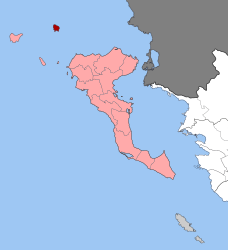
|map_caption = Location within the regional unit |
|
|map_caption = Location within the regional unit |
|
|periph = ] |
|
|
|periphunit = ] |
|
|periph = ] |
|
|municipality = ] |
|
|periphunit = ] |
|
|
|municipality = ] |
|
|pop_municunit = 496 |
|
|pop_municunit = 447 |
|
|population_as_of = 2011 |
|
|population_as_of = 2021 |
|
|area_municunit = 4.449 |
|
|area_municunit = 4.449 |
|
|elevation_min = |
|
|elevation_min = |
|
|coordinates = {{coord|39|53|N|19|35|E|format=dms|display=inline,title}} |
|
|coordinates = {{coord|39|53|N|19|35|E|format=dms|display=inline,title}} |
|
|website = {{url|http://www.diapontia.gr}} |
|
|website = {{URL|http://www.diapontia.gr}} |
|
}} |
|
}} |
|
|
|
|
|
'''Ereikoussa''' ({{lang-gr|Ερεικούσσα}}, {{lang-it|Merlera}}) is an island and a former community of the ], ]. It is one of the ], an island complex to the northwest of ]. Since the 2019 local government reform it is part of the municipality of ], of which it is a municipal unit.<ref name=gazette>{{Cite web|url=http://www.et.gr/idocs-nph/search/pdfViewerForm.html?args=5C7QrtC22wFqnM3eAbJzrXdtvSoClrL87TVLbP6RgP3tIl9LGdkF53UIxsx942CdyqxSQYNuqAGCF0IfB9HI6qSYtMQEkEHLwnFqmgJSA5UkHEKavWyL4FoKqSe4BlOTSpEWYhszF8P8UqWb_zFijOYvZQ9oVzh_eHrjhF2IgFB0wiv-nanwQoPLtSkFjBWO|title=Τροποποίηση του άρθρου 1 του ν. 3852/2010|trans-title=Amendment of Article 1 of l. 3852/2010|page=1164|language=el|publisher=]}}</ref> It is located off the northwestern coast of the island of ], and is almost equidistant from Corfu to the southeast, ] to the southwest, and ] to the west. There is only one town on the island, also named Ereikoússa. Its population was 496 at the 2011 census and its land area is {{convert|3.65|km²|0|abbr=out}}. The municipal unit has an area of 4.449 km<sup>2</sup>.<ref name=stat01>{{cite web |url=http://dlib.statistics.gr/Book/GRESYE_02_0101_00098%20.pdf |publisher=National Statistical Service of Greece |title=Population & housing census 2001 (incl. area and average elevation) |language=el |url-status=dead |archiveurl=https://web.archive.org/web/20150921212047/http://dlib.statistics.gr/Book/GRESYE_02_0101_00098%20.pdf |archivedate=2015-09-21 }}</ref> The island is rich in green forests, filled with cypress, and olive trees. It has two beaches, Porto (Πόρτο) and Braghini (Μπραγκίνι); the names are of Italian origin, and date back to the period of ] rule.{{Citation needed|date=May 2022}} Braghini is rarely visited because it is further away from the main part of the island. |
|
'''Erikoussa''' ({{langx|el|Ερεικούσσα}}) is an island and a former community of the ], ]. It is one of the ]; an island complex to the northwest of ]. Since the ] it is part of the municipality of ], of which it is a municipal unit.<ref name=gazette>{{Cite web|url=http://www.et.gr/idocs-nph/search/pdfViewerForm.html?args=5C7QrtC22wFqnM3eAbJzrXdtvSoClrL87TVLbP6RgP3tIl9LGdkF53UIxsx942CdyqxSQYNuqAGCF0IfB9HI6qSYtMQEkEHLwnFqmgJSA5UkHEKavWyL4FoKqSe4BlOTSpEWYhszF8P8UqWb_zFijOYvZQ9oVzh_eHrjhF2IgFB0wiv-nanwQoPLtSkFjBWO|title=Τροποποίηση του άρθρου 1 του ν. 3852/2010|trans-title=Amendment of Article 1 of l. 3852/2010|page=1164|language=el|publisher=]}}</ref> It is located off the northwestern coast of the island of ], and is almost equidistant from Corfu to the southeast, ] to the southwest, and ] to the west. Its population was 447 in the ], and its land area is {{convert|3.65|km²|0|abbr=out}}. The municipal unit has an area of 4.449 km<sup>2</sup>.<ref name=stat01>{{cite web |url=http://dlib.statistics.gr/Book/GRESYE_02_0101_00098%20.pdf |publisher=National Statistical Service of Greece |title=Population & housing census 2001 (incl. area and average elevation) |language=el |url-status=dead |archiveurl=https://web.archive.org/web/20150921212047/http://dlib.statistics.gr/Book/GRESYE_02_0101_00098%20.pdf |archivedate=2015-09-21 }}</ref> It has six settlements; the main one is Porto (Πόρτο), which is also where the only port is located.<ref name="Pronews">{{Cite news |date=11 June 2019 |title=Διαπόντια Νησιά: Το "άγνωστο" δυτικότερο άκρο της Ελλάδας (φωτο) |language=el |website=Pronews.gr |url=https://www.pronews.gr/travel/779361_diapontia-nisia-agnosto-dytikotero-akro-tis-elladas-foto/ |access-date=24 June 2022}}</ref><ref name="Lifo">{{Cite news |date=19 August 2019 |title=10 εναλλακτικά και άγνωστα παραδεισένια νησιά της Ελλάδας |language=el |website=] |url=https://www.lifo.gr/tropos-zois/travel/10-enallaktika-kai-agnosta-paradeisenia-nisia-tis-elladas |access-date=24 June 2022}}</ref> The island has dense vegetation and three beaches; Porto (Πόρτο), Bragini (Μπραγκίνι), and Fiki (Φύκι).<ref name="Lifo" /><ref name="Ethnos">{{Cite news |date=24 May 2022 |title=Μια σταλιά νησάκι, σαν από άλλη εποχή: Η "γαλάζια λίμνη" του Ιονίου που ανταγωνίζεται στα ίσα Κέρκυρα και Κεφαλονιά |language=el |website=] |url=https://www.ethnos.gr/travel/article/209155/miastalianhsakisanapoallhepoxhhgalazialimnhtoyionioypoyantagonizetaistaisakerkyrakaikefalonia |access-date=24 June 2022}}</ref> The name Ereikoussa derives from the plant '']'' (ερείκη), which can be found throughout the island.<ref name="Pronews" /><ref name="Lifo" /><ref name="Ethnos" /> |
|
|
|
|
The two primary ways to get to Ereikoussa are through a boat called ''Pegasus'' that leaves from Sidari, a city in northern Corfu, or the ''EVDOKIA'', a boat that leaves from Corfu Town. The ''Sea Away'' takes about 40 min. while the ''EVDOKIA'' takes about 2 hours 30 min. |
|
|
|
|
|
|
==References== |
|
==References== |


