| Revision as of 14:27, 10 June 2012 editSfan00 IMG (talk | contribs)505,076 edits Help needed: Monkey Island← Previous edit | Latest revision as of 21:20, 6 February 2022 edit undoQwerfjkl (bot) (talk | contribs)Bots, Mass message senders4,012,731 editsm Capitalising short description "lock on the River Thames in Buckinghamshire, England" per WP:SDFORMAT (via Bandersnatch) | ||
| (13 intermediate revisions by 12 users not shown) | |||
| Line 1: | Line 1: | ||
| {{Short description|Lock on the River Thames in Buckinghamshire, England}} | |||
| {{Use dmy dates|date=November 2016}} | |||
| {{Use British English|date=November 2016}} | |||
| {{stack begin}} | {{stack begin}} | ||
| {{Infobox |
{{Infobox waterlock | ||
| |lock_name = Boveney Lock | |||
| |lock_name = Boveney Lock<ref> Part 2 p29</ref> | |||
| |image= BoveneyLock02.JPG | |image= BoveneyLock02.JPG | ||
| |caption= Boveney Lock, with a bridge across the |
|caption= Boveney Lock, with a bridge across the Portage to private mooring. Windsor Racecourse can be seen on the far bank | ||
| |waterway = ] | |waterway = ] | ||
| |county = ] | |county = ] | ||
| Line 10: | Line 13: | ||
| |first = 1838 | |first = 1838 | ||
| |latest = 1898 | |latest = 1898 | ||
| |length = {{convert|45.59|m|ftin|abbr=on}} <ref name="EnvAgency" >{{cite web |url=http://www.environment-agency.gov.uk/homeandleisure/recreation/135271.aspx |title=Environment Agency Dimensions of locks on the River Thames |date=8 November 2012 |work=web page |publisher=Environmental Agency |accessdate=18 November 2012}} Dimensions given in metres</ref> | |||
| |length = {{convert|149|ft|7|in|m|abbr=on}} | |||
| |width = {{convert| |
|width = {{convert|5.43|m|ftin|abbr=on}}<ref name="EnvAgency" /> | ||
| |fall = {{convert| |
|fall = {{convert|1.47|m|ftin|abbr=on}}<ref name="EnvAgency" /> | ||
| |sealevel = {{convert|64|ft|m}} | |sealevel = {{convert|64|ft|m}} | ||
| |enda = ] | |enda = ] | ||
| Line 25: | Line 29: | ||
| | lat= | | lat= | ||
| | long= | | long= | ||
| | extra= Power is available out of hours | | extra= Power is available out of hours. | ||
| }} | }} | ||
| {{Boveney Lock map}} | {{Boveney Lock map}} | ||
| {{stack end}} | {{stack end}} | ||
| '''Boveney Lock''' is a ] on the ] situated on the ] bank opposite the ] and close to ]. ] is a village a little way upstream on the same side. The lock was first built in 1838 by the ]. The lock was rebuilt in 1898 closer to the Buckinghamshire bank, and a set of boat rollers were installed on the old site. | '''Boveney Lock''' is a ] on the ] situated on the ] bank opposite the ] and close to ]. ] is a village a little way upstream on the same side. The lock was first built in 1838 by the ]. The lock was rebuilt in 1898 closer to the Buckinghamshire bank, and a set of boat rollers were installed on the old site. | ||
| The weir is almost parallel to the lock, running across from the other side of the lock island. | The ] is almost parallel to the lock, running across from the other side of the lock island. | ||
| ==History== | ==History== | ||
| Line 42: | Line 45: | ||
| ==Reach above the lock== | ==Reach above the lock== | ||
| ] | ] | ||
| On the ] bank the land towards ] is open fields with ] behind. On the ] bank the river passes ] which is at the entrance to ]. There are |
On the ] bank the land towards ] is open fields with ] behind. On the ] bank the river passes ] which is at the entrance to ]. There are houses at ], a caravan park and Windsor Marina before ], home of many ] films. Upstream is ], owned by ], opposite Bray Marina. ] then joins the river from "The Cut" on the southern bank. ] here was built as a gravel conveyor for the building of Dorney Lake and is now a pedestrian bridge. ] is a short way upstream and then the ] crosses the river a little way below Bray Lock. | ||
| ===Sports clubs=== | ===Sports clubs=== | ||
| *] | * ] | ||
| ===Thames Path=== | ===Thames Path=== | ||
| ] | ] | ||
| ] | ] | ||
| The ] stays on the northern side of the river to Bray lock. | The ] stays on the northern side of the river to Bray lock. | ||
| Line 57: | Line 60: | ||
| * ] | * ] | ||
| * ] | * ] | ||
| ⚫ | ==References== | ||
| ⚫ | {{Reflist}} | ||
| {{S-start}} | {{S-start}} | ||
| {{River lock start|River=]}} | {{River lock start|River=]}} | ||
| {{River lock line|upstream=]<br/> |
{{River lock line|upstream=]<br/> {{convert|5.10|km|abbr=on}} <ref name="EnvAgency2" >{{cite web |url= http://www.environment-agency.gov.uk/homeandleisure/recreation/131811.aspx |title=Environment Agency Distances between locks on the River Thames |date=19 November 2012 |work=web page |publisher=Environmental Agency |accessdate=21 November 2012}} Distances given in km.</ref>|downstream=]<br/> {{convert|3.75|km|abbr=on}}<ref name="EnvAgency2" />|location=SU944777}} | ||
| {{S-end}} | {{S-end}} | ||
| ⚫ | ==References== | ||
| ⚫ | {{Reflist}} | ||
| {{coord|51.49038|-0.64171|type:landmark_region:GB_source:enwiki-osgb36(SU944777)|display=title}} | {{coord|51.49038|-0.64171|type:landmark_region:GB_source:enwiki-osgb36(SU944777)|display=title}} | ||
Latest revision as of 21:20, 6 February 2022
Lock on the River Thames in Buckinghamshire, England
| Boveney Lock | |
|---|---|
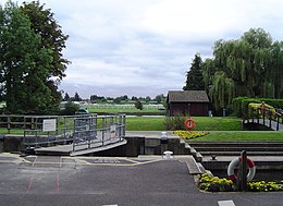
 Boveney Lock, with a bridge across the Portage to private mooring. Windsor Racecourse can be seen on the far bank Boveney Lock, with a bridge across the Portage to private mooring. Windsor Racecourse can be seen on the far bank | |
| Waterway | River Thames |
| County | Buckinghamshire |
| Maintained by | Environment Agency |
| Operation | Hydraulic |
| First built | 1838 |
| Latest built | 1898 |
| Length | 45.59 m (149 ft 7 in) |
| Width | 5.43 m (17 ft 10 in) |
| Fall | 1.47 m (4 ft 10 in) |
| Above sea level | 64 feet (20 m) |
| Distance to Teddington Lock | 26 miles (42 km) |
| Power is available out of hours. | |
| Boveney Lock | |||||||||||||||||||||||||||||||||||||||||||||||||||||||||||||||||||||||||||||||||||||||||||||||||||||||||||||||||||||||||||||||||||||||||||||||||||||||||||||||||
|---|---|---|---|---|---|---|---|---|---|---|---|---|---|---|---|---|---|---|---|---|---|---|---|---|---|---|---|---|---|---|---|---|---|---|---|---|---|---|---|---|---|---|---|---|---|---|---|---|---|---|---|---|---|---|---|---|---|---|---|---|---|---|---|---|---|---|---|---|---|---|---|---|---|---|---|---|---|---|---|---|---|---|---|---|---|---|---|---|---|---|---|---|---|---|---|---|---|---|---|---|---|---|---|---|---|---|---|---|---|---|---|---|---|---|---|---|---|---|---|---|---|---|---|---|---|---|---|---|---|---|---|---|---|---|---|---|---|---|---|---|---|---|---|---|---|---|---|---|---|---|---|---|---|---|---|---|---|---|---|---|---|
| Legend | |||||||||||||||||||||||||||||||||||||||||||||||||||||||||||||||||||||||||||||||||||||||||||||||||||||||||||||||||||||||||||||||||||||||||||||||||||||||||||||||||
| |||||||||||||||||||||||||||||||||||||||||||||||||||||||||||||||||||||||||||||||||||||||||||||||||||||||||||||||||||||||||||||||||||||||||||||||||||||||||||||||||
Boveney Lock is a lock on the River Thames situated on the Buckinghamshire bank opposite the Windsor Racecourse and close to Eton Wick. Boveney is a village a little way upstream on the same side. The lock was first built in 1838 by the Thames Navigation Commission. The lock was rebuilt in 1898 closer to the Buckinghamshire bank, and a set of boat rollers were installed on the old site.
The weir is almost parallel to the lock, running across from the other side of the lock island.
History
Although the river below Maidenhead was supposed to be clear of weirs, there is record of a weir and flash lock at Gill's bucks a short way upstream of the present site. There were suggestions of a pound lock here as early as 1780, and various plans for a lock were proposed in 1820. These plans proposed cuts to the mouth of Clewer Mill Stream because of difficult navigation of the tight bends downstream. However, the present location was eventually chosen, with a timber lock built in 1838. With the regular traffic of boats from Eton College to Queen's Eyot, a temporary boat slide was built in 1895, which became permanent on the site of the old lock when a new lock was built immediately to the side in 1898. The weir was rebuilt in about 1913.
Access to the lock
The lock is some distance from any road, and can be reached by walking to the river from Eton Wick and following the towpath.
Reach above the lock

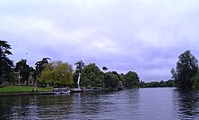
On the Buckinghamshire bank the land towards Dorney is open fields with Dorney Lake behind. On the Berkshire bank the river passes Bush Ait which is at the entrance to Clewer Mill Stream. There are houses at Dedworth, a caravan park and Windsor Marina before Oakley Court, home of many Hammer horror films. Upstream is Queens Eyot, owned by Eton College, opposite Bray Marina. York Stream then joins the river from "The Cut" on the southern bank. Summerleaze Footbridge here was built as a gravel conveyor for the building of Dorney Lake and is now a pedestrian bridge. Monkey Island is a short way upstream and then the M4 Bridge crosses the river a little way below Bray Lock.
Sports clubs
Thames Path


The Thames Path stays on the northern side of the river to Bray lock.
See also
| Next lock upstream | River Thames | Next lock downstream |
| Bray Lock 5.10 km (3.17 mi) |
Boveney Lock Grid reference: SU944777 |
Romney Lock 3.75 km (2.33 mi) |
References
- ^ "Environment Agency Dimensions of locks on the River Thames". web page. Environmental Agency. 8 November 2012. Retrieved 18 November 2012. Dimensions given in metres
- Fred. S. Thacker The Thames Highway: Volume II Locks and Weirs 1920 - republished 1968 David & Charles
- ^ "Environment Agency Distances between locks on the River Thames". web page. Environmental Agency. 19 November 2012. Retrieved 21 November 2012. Distances given in km.
51°29′25″N 0°38′30″W / 51.49038°N 0.64171°W / 51.49038; -0.64171
Categories: