| Revision as of 00:58, 25 May 2020 edit62.4.55.44 (talk) →Famous people descending from Njeguši← Previous edit |
Latest revision as of 09:50, 25 March 2024 edit undoSrpskiAnonimac (talk | contribs)Extended confirmed users32,669 editsmNo edit summary |
| (34 intermediate revisions by 15 users not shown) |
| Line 1: |
Line 1: |
|
{{about|the village|the tribe|Njeguši (tribe)}} |
|
{{For|the tribe of Montenegro in Katunska nahija|Njeguši (tribe)}} |
|
|
{{Infobox settlement |
|
{{Multiple issues| |
|
|
|
|official_name = Njeguši |
|
{{more citations needed|date=December 2009}} |
|
|
|
|other_name = |
|
{{disputed|date=December 2009}} |
|
|
|
|native_name = Његуши |
|
|
|nickname = |
|
|
|settlement_type = ] |
|
|
|motto = |
|
|
|image_skyline = View over Njegusi.jpg |
|
|
|imagesize = |
|
|
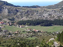
|image_caption = View over Njeguši with the ] in the background, 2012 |
|
|
|image_flag = |
|
|
|flag_size = |
|
|
|image_seal = |
|
|
|seal_size = |
|
|
|image_map = |
|
|
|mapsize = |
|
|
|map_caption = |
|
|
|pushpin_map = Montenegro |
|
|
|pushpin_label_position = bottom<!-- the position of the pushpin label: left, right, top, bottom, none --> |
|
|
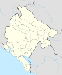
|pushpin_map_caption = Location within Montenegro |
|
|
|pushpin_mapsize = |
|
|
<!-- Location ------------------> |
|
|
|subdivision_type = ] |
|
|
|subdivision_name = {{MNE}} |
|
|
|subdivision_type1 = ] |
|
|
|subdivision_name1 = ] ] |
|
|
|government_footnotes = |
|
|
|government_type = |
|
|
|leader_title = |
|
|
|leader_name = |
|
|
|established_title = |
|
|
|established_date = |
|
|
|area_magnitude = |
|
|
|unit_pref = |
|
|
|area_footnotes = |
|
|
|area_total_km2 = |
|
|
|area_land_km2 = |
|
|
|population_as_of = 2011 |
|
|
|population_footnotes = |
|
|
|population_note = |
|
|
|population_total = 35 |
|
|
|population_density_km2 = |
|
|
|timezone = ] |
|
|
|utc_offset = +1 |
|
|
|timezone_DST = ] |
|
|
|utc_offset_DST = +2 |
|
|
|coordinates = {{coord|42.4331|N|18.8283|E|source:kolossus-frwiki|display=title}} |
|
|
|elevation_footnotes = |
|
|
|elevation_m = |
|
|
|elevation_ft = |
|
|
|postal_code_type = |
|
|
|postal_code = |
|
|
|area_code = |
|
|
|blank_name = |
|
|
|blank_info = |
|
|
|website = |
|
|
|footnotes = |
|
}} |
|
}} |
|
|
|
|
|
|
'''Njeguši''' (]: Његуши) is a village in the ] of southern ], located on the slopes of ], within the Lovćen national park. It is part of the historical territory of the ] tribe. |
|
] |
|
|
] |
|
|
] |
|
|
|
|
|
|
|
==Demographics== |
|
'''Njeguši''' (] and {{lang-sr-cyr|Његуши}}) is a village in the ] of southern ], located on the slopes of ], within the Lovćen national park. The village is best known as the birthplace of the ]<nowiki> dynasty, which ruled Montenegro from 1696 to 1918, as well as the Montenegrin office of the ''serdar'' and ''guvernadur'', held by the </nowiki>Radonjić family. The village is also significant for its well-preserved traditional ]. |
|
|
|
According to the 2003 census, the village had 17 inhabitants, of whom 15 declared as ], 1 as ], and 1 Unknown. According to 2011 census, there were 35 inhabitants, 33 of whom were Montenegrins, one did not want to reveal ethnicity and one was a Russian.<ref>Zavod za Statistiku Crne Gore. 2011. "Popis na nivou nasejla." http://www.monstat.org/cg/page.php?id=536&pageid=322</ref><ref>{{cite book|title=Становништво, национална или етничка припадност, подаци по насељима|publisher=Републички завод за статистику (2004)|location=Подгорица|isbn=978-86-84433-00-0}}</ref> |
|
''Njeguški sir'' and '']'' (local forms of ] and ] respectively), made solely in area around Njeguši, are genuine contributions to ]. The village is situated in the Njeguši field and historically used to be a center of the tribe of the same name that formed a part of Katunska Nahija, one of the provinces of ]. The village consists of the settlements: Dugi Do, Žanjev Do, Erakovići, Kopito, Vrba, Raićevići, Velji and Mali Zalazi, Majstori and ]. The name Njeguši is according to Ilija Ruvarac derived from Negusius Podcupica, mentioned in an 11th-century document. The original house the Petrović Family used to live in is located at 42.432271, 18.808675. |
|
|
|
|
|
According to the 2003 census, the village had 17 inhabitants, of whom 15 declared as ], 1 as ], and 1 Unknown. According to 2011 census, there were 35 inhabitants, 33 of whom were Montenegrins, one did not want to reveal ethnicity and one was a Russian.<ref>Zavod za Statistiku Crne Gore. 2011. "Popis na nivou nasejla." http://www.monstat.org/cg/page.php?id=536&pageid=322</ref> |
|
|
|
|
|
==Famous people descending from Njeguši== |
|
|
*] |
|
|
*] |
|
|
*] |
|
|
*] |
|
|
*] |
|
|
*] |
|
|
*] |
|
|
*] |
|
|
*] |
|
|
*] |
|
|
*] |
|
|
*] |
|
|
*] |
|
|
*] |
|
|
*] |
|
|
*] |
|
|
*] |
|
|
*] |
|
|
*] |
|
|
*] |
|
|
*] |
|
|
*] |
|
|
*] |
|
|
*] |
|
|
*] |
|
|
*] |
|
|
*] |
|
|
*] |
|
|
*] |
|
|
*] |
|
|
*] |
|
|
*] |
|
|
*] |
|
|
|
|
|
|
==References== |
|
==References== |
|
{{Reflist}} |
|
{{Reflist}} |
|
|
|
|
{{Commons category|Njeguši}} |
|
|
|
|
|
{{coord|42.4331|N|18.8283|E|source:kolossus-frwiki|display=title}} |
|
|
|
|
|
|
{{Cetinje}} |
|
{{Cetinje}} |
|
|
{{Authority control}} |
|
|
|
|
{{DEFAULTSORT:Njegusi}} |
|
{{DEFAULTSORT:Njegusi}} |
|
] |
|
] |
|
|
|
|
{{Montenegro-geo-stub}} |
|
{{Montenegro-geo-stub}} |
According to the 2003 census, the village had 17 inhabitants, of whom 15 declared as Montenegrins, 1 as Serb, and 1 Unknown. According to 2011 census, there were 35 inhabitants, 33 of whom were Montenegrins, one did not want to reveal ethnicity and one was a Russian.
 View over Njeguši with the Bay of Kotor in the background, 2012