| Revision as of 23:05, 26 July 2021 editAqşin Abbaslı (talk | contribs)Extended confirmed users1,058 editsNo edit summaryTags: Visual edit Mobile edit Mobile web edit← Previous edit | Revision as of 08:13, 1 June 2022 edit undoAntonSamuel (talk | contribs)Extended confirmed users, Page movers14,056 edits CleanupNext edit → | ||
| Line 1: | Line 1: | ||
| {{coord|39|09|22|N|46|48|41|E|display=title}} | |||
| {{Infobox settlement | {{Infobox settlement | ||
| | official_name = Mammadbeyli | | official_name = Mammadbeyli | ||
| | native_name = {{lang-az|Məmmədbəyli}} | | native_name = {{lang-az|Məmmədbəyli}} | ||
| | image_skyline = İlham Əliyev Qubadlı və Zəngilan rayonlarında olub 25.jpg | |||
| ⚫ | | image_caption = | ||
| | image_size = 300px | |||
| | pushpin_map = Azerbaijan | | pushpin_map = Azerbaijan | ||
| | pushpin_mapsize = 300 | | pushpin_mapsize = 300 | ||
| Line 20: | Line 22: | ||
| | timezone = ] | | timezone = ] | ||
| | utc_offset = +4 | | utc_offset = +4 | ||
| | timezone_DST = |
| timezone_DST = | ||
| | utc_offset_DST = |
| utc_offset_DST = | ||
| | coordinates = {{coord|39|09|22|N|46|48|41|E|region:AZ|display=inline}} | | coordinates = {{coord|39|09|22|N|46|48|41|E|region:AZ|display=inline,title}} | ||
| | elevation_m = | | elevation_m = | ||
| | area_code = | | area_code = | ||
| | website = | | website = | ||
| | image_skyline = Mausoleum in Mamedbeyli-IMG 8021.JPG | |||
| ⚫ | | image_caption = |
||
| }} | }} | ||
| '''Mammadbeyli''' ({{lang-az|Məmmədbəyli}}) is a village in the ] of ].<ref>{{GEOnet2|32FA881504323774E0440003BA962ED3}}</ref> | '''Mammadbeyli''' ({{lang-az|Məmmədbəyli}}) is a village in the ] of ].<ref>{{GEOnet2|32FA881504323774E0440003BA962ED3}}</ref> | ||
| ==History== | == History == | ||
| The village was located in the ], coming under the control of ethnic Armenian forces during the ] in the early 1990s. | The village was located in the ], coming under the control of ethnic Armenian forces during the ] in the early 1990s. The village subsequently became part of the breakaway ] as part of its ], referred to as '''Vardanants''' ({{lang-hy|Վարդանանց}}). It was recaptured by Azerbaijan on 20 October 2020 during the ].<ref>{{cite web |url=https://mod.gov.az/en/news/president-ilham-aliyev-zangilan-city-and-6-villages-of-the-district-18-villages-of-fuzuli-jabrayil-and-khojavand-distric-33131.html |title=President Ilham Aliyev: Zangilan city and 6 villages of the district, 18 villages of Fuzuli, Jabrayil, and Khojavand districts liberated |author=<!--Not stated--> |date=20 October 2020 |website=mod.gov.az }}</ref> | ||
| == Gallery == | |||
| The village subsequently became part of the self-proclaimed ] as part of its ], referred to as '''Vardanants''' ({{lang-hy|Վարդանանծ}}). | |||
| <gallery mode="packed-hover" heights="180"> | |||
| ZəngilanDSC 0290.jpg| | |||
| It was recaptured by Azerbaijan on 20 October 2020 during the ].<ref>{{cite web |url=https://mod.gov.az/en/news/president-ilham-aliyev-zangilan-city-and-6-villages-of-the-district-18-villages-of-fuzuli-jabrayil-and-khojavand-distric-33131.html |title=President Ilham Aliyev: Zangilan city and 6 villages of the district, 18 villages of Fuzuli, Jabrayil, and Khojavand districts liberated |author=<!--Not stated--> |date=20 October 2020 |website=mod.gov.az }}</ref> | |||
| Mausoleum in Mamedbeyli-IMG 8021.JPG|Mausoleum in Mammadbeyli | |||
| ZəngilanDSC 0274.jpg| | |||
| ZəngilanDSC 0279.jpg| | |||
| </gallery> | |||
| == References == | == References == | ||
| {{ |
{{Reflist}} | ||
| {{Zangilan Rayon}} | {{Zangilan Rayon}} | ||
| {{Kashatagh Province}} | {{Kashatagh Province}} | ||
| {{Portal bar|Geography}} | |||
| {{DEFAULTSORT:Memmedbeyli}} | {{DEFAULTSORT:Memmedbeyli}} | ||
| ] | ] | ||
| {{Zangilan-geo-stub}} | {{Zangilan-geo-stub}} | ||
Revision as of 08:13, 1 June 2022
Place in Zangilan, Azerbaijan| Mammadbeyli Template:Lang-az | |
|---|---|
 | |
 | |
| Coordinates: 39°09′22″N 46°48′41″E / 39.15611°N 46.81139°E / 39.15611; 46.81139 | |
| Country | |
| District | Zangilan |
| Time zone | UTC+4 (AZT) |
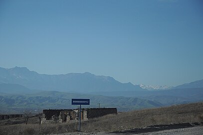
Mammadbeyli (Template:Lang-az) is a village in the Zangilan District of Azerbaijan.
History
The village was located in the Armenian-occupied territories surrounding Nagorno-Karabakh, coming under the control of ethnic Armenian forces during the First Nagorno-Karabakh War in the early 1990s. The village subsequently became part of the breakaway Republic of Artsakh as part of its Kashatagh Province, referred to as Vardanants (Template:Lang-hy). It was recaptured by Azerbaijan on 20 October 2020 during the 2020 Nagorno-Karabakh war.
Gallery
References
- Məmmədbəyli at GEOnet Names Server
- "President Ilham Aliyev: Zangilan city and 6 villages of the district, 18 villages of Fuzuli, Jabrayil, and Khojavand districts liberated". mod.gov.az. 20 October 2020.
This Zangilan Rayon location article is a stub. You can help Misplaced Pages by expanding it. |


