| Revision as of 00:39, 3 December 2008 editThe Anomebot2 (talk | contribs)Bots, Extended confirmed users1,043,658 edits Adding geodata: {{coord|18|45|14.74|N|98|59|44.0|E|type:landmark_region:TH-50_source:dewiki|display=title}}← Previous edit | Revision as of 06:12, 4 January 2009 edit undoLightbot (talk | contribs)791,863 edits Units/dates/otherNext edit → | ||
| Line 1: | Line 1: | ||
| ] | ] | ||
| '''Wiang Kum Kam''' is the recently restored original settlement along the ], predating ]. It was flooded and abandoned more than 700 years ago; that move became more understandable in |
'''Wiang Kum Kam''' is the recently restored original settlement along the ], predating ]. It was flooded and abandoned more than 700 years ago; that move became more understandable in 2005, when the ancient city was flooded three separate times and the river left its banks in that area of Chiang Mai. | ||
| The main temple of the town is ] (Wat Kuu Kham), which is still occupied by monks. | The main temple of the town is ] (Wat Kuu Kham), which is still occupied by monks. | ||
Revision as of 06:12, 4 January 2009

Wiang Kum Kam is the recently restored original settlement along the Ping River, predating Chiang Mai. It was flooded and abandoned more than 700 years ago; that move became more understandable in 2005, when the ancient city was flooded three separate times and the river left its banks in that area of Chiang Mai.
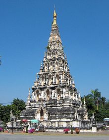
The main temple of the town is Wat Chedi Liem (Wat Kuu Kham), which is still occupied by monks.
This Thailand location article is a stub. You can help Misplaced Pages by expanding it. |
18°45′14.74″N 98°59′44.0″E / 18.7540944°N 98.995556°E / 18.7540944; 98.995556
Category: