| Revision as of 03:55, 1 February 2009 editShunpiker (talk | contribs)Extended confirmed users6,902 edits Added image← Previous edit | Revision as of 18:09, 16 August 2009 edit undoBackspace (talk | contribs)Autopatrolled, Extended confirmed users, Pending changes reviewers33,903 edits To provide geographical coordinatesNext edit → | ||
| Line 12: | Line 12: | ||
| {{YukonKoyukukAK-geo-stub}} | {{YukonKoyukukAK-geo-stub}} | ||
| {{coord|66|10|00|N|142|20|00|W|display=title}} | |||
| {{coord missing|Alaska}} | |||
| ] | ] | ||
Revision as of 18:09, 16 August 2009

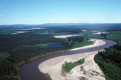
The Black River is a river in eastern Yukon-Koyukuk Census Area, Alaska, United States. It flows 160 miles (250 km) from its source to its mouth at the Porcupine River near the city of Fort Yukon. The river has borne several other names: Big Black River (in order to distinguish it from similarly-named streams), Orange Creek, Salmon Fork, Salmon River, Squirrel Creek, and Squirrel River; the Board on Geographic Names officially ruled in favor of "Black River" in 1959.
See also
References
This article about a location in the Yukon-Koyukuk Census Area, Alaska is a stub. You can help Misplaced Pages by expanding it. |
66°10′00″N 142°20′00″W / 66.16667°N 142.33333°W / 66.16667; -142.33333
Categories: