| Revision as of 20:48, 1 February 2006 editJohantheghost (talk | contribs)Extended confirmed users2,955 edits Distance correction← Previous edit | Revision as of 23:17, 1 February 2006 edit undoJohantheghost (talk | contribs)Extended confirmed users2,955 edits →GeographyNext edit → | ||
| Line 12: | Line 12: | ||
| The '''Cape of Good Hope''' is often thought of as being the southernmost point in Africa, and the dividing point between the ] and ]s; however, this is actually ], which lies about 150 kilometres (90 mi) east-south-east. ] is about thirty kilometres to the north of the Cape, in ] at the north end of the peninsula. | The '''Cape of Good Hope''' is often thought of as being the southernmost point in Africa, and the dividing point between the ] and ]s; however, this is actually ], which lies about 150 kilometres (90 mi) east-south-east. ] is about thirty kilometres to the north of the Cape, in ] at the north end of the peninsula. | ||
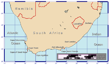
| ] and ].]] | ], illustrating the positions of the ] and ].]] | ||
| Both the Cape of Good Hope and ] offer spectacular scenery. Indeed, the whole of the southernmost portion of the Cape Peninsula is a wild, rugged, scenic and generally unspoiled national park. | Both the Cape of Good Hope and ] offer spectacular scenery. Indeed, the whole of the southernmost portion of the Cape Peninsula is a wild, rugged, scenic and generally unspoiled national park. | ||
Revision as of 23:17, 1 February 2006

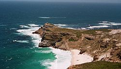
The Cape of Good Hope (Afrikaans: Kaap die Goeie Hoop, Dutch: Kaap de Goede Hoop) is a rocky headland on the Atlantic coast of South Africa, about 150 kilometres (90 mi) from the southern tip of Africa. While it is possibly the best-known of the southern African capes, it is not actually the southernmost point of the continent; however, its first rounding was a major milestone in European attempts to establish a sea route to the Far East.
As one of the great capes of the Southern Ocean, the Cape of Good Hope has been of special significance to sailors for many years, and is widely referred to by them simply as The Cape. The Cape is a major milestone on the clipper route followed by clipper ships to the Far East and Australia, and still followed by several offshore yacht races.
The term Cape of Good Hope was also used to indicate the early European colony in the vicinity of the cape.
Geography

The Cape of Good Hope is located at 34°21′29″S 18°28′19″E / 34.35806°S 18.47194°E / -34.35806; 18.47194. It is at the south-west corner of the Cape Peninsula, about 2.3 kilometres (1.4 mi) west and a little south of Cape Point on the south-east corner. The peninsula forms the western boundary of False Bay. Geologically, the two capes and the peninsula are part of the Table Mountain Group, and are formed of the same type of sandstones as those exposed in the faces of Table Mountain itself.
The Cape of Good Hope is often thought of as being the southernmost point in Africa, and the dividing point between the Atlantic and Indian Oceans; however, this is actually Cape Agulhas, which lies about 150 kilometres (90 mi) east-south-east. Cape Town is about thirty kilometres to the north of the Cape, in Table Bay at the north end of the peninsula.

Both the Cape of Good Hope and Cape Point offer spectacular scenery. Indeed, the whole of the southernmost portion of the Cape Peninsula is a wild, rugged, scenic and generally unspoiled national park.
The term Cape of Good Hope has also been used in a wider sense, to indicate the area of the early European colony in the vicinity of the cape.
History

The Cape of Good Hope was first rounded by Portuguese navigator Bartolomeu Dias in 1488 and he named it the "Cape of Storms" (Cabo de las Tormentas). It was later renamed by John II of Portugal as "Cape of Good Hope" (Cabo de Buena Esperanza) because of the great optimism engendered by the opening of a sea route to the east.
The land around Kaap De Goede Hoop (Dutch for Cape of Good Hope) was home to the Khoikhoi (Hottentot) people when the Dutch first settled there in 1652. The Khoikhoi had first arrived in these parts about fifteen hundred years before.
Dutch merchant Jan van Riebeeck established a resupply camp for the Dutch East India Company near the Cape on April 6, 1652 and this eventually developed into Cape Town. Supplies of fresh food were vital on the long journey around Africa and Cape Town became known as "The Tavern of the Seas".
On December 31, 1687 a band of Huguenots arrived at the Cape from the Netherlands. They had escaped to the Netherlands from France in order to flee religious persecution there. The Dutch East India Company needed skilled farmers at the Cape of Good Hope and the Netherlands Government saw opportunities for the Huguenots at the Cape and sent them over. The colony gradually grew over the next 150 years or so until it stretched for hundreds of kilometres to the north and north-east.

The United Kingdom invaded and occupied the Cape Colony in 1795 ("The First Occupation") but relinquished control of the territory in 1803. However, British forces returned on January 19, 1806 and occupied the Cape once again ("The Second Occcupation"). The territory was ceded to the UK in the Anglo-Dutch Treaty of 1814 and was henceforth administered as the Cape Colony. It remained a British colony until incorporated into the independent Union of South Africa in 1910 (now known as the Republic of South Africa).
The Portuguese government erected two navigational beacons, Diaz Cross and Da Gama Cross, to commemorate Vasco da Gama and Bartolomeu Dias as explorers. When lined up, the crosses point to Whittle Rock (34°14.8′S 18°33.6′E / 34.2467°S 18.5600°E / -34.2467; 18.5600), a large, permanently submerged shipping hazard in False Bay. Two other beacons in Simonstown provide the intersection.
Legends
The Cape of Good Hope is the legendary home of The Flying Dutchman. Crewed by tormented and damned ghostly sailors, it is doomed forever to beat its way through the adjacent waters without ever succeeding in rounding the headland.
See also
- History of Cape Colony
- Cape Province
- Cape Horn, its South American counterpart
References
- Along the Clipper Way, Francis Chichester; page 78. Hodder & Stoughton, 1966. ISBN 0340001917
- Topo map of the Cape of Good Hope, from the South African Geographical Names System
- Historic Cape of Good Hope Land Grants and related histories