| Revision as of 21:34, 28 February 2011 editSupreme Deliciousness (talk | contribs)Extended confirmed users, Pending changes reviewers, Rollbackers22,593 edits Its not located in Israel.← Previous edit | Revision as of 07:23, 3 March 2011 edit undoBsadowski1 (talk | contribs)Edit filter managers, Administrators16,813 editsm Protected Dung Gate: Persistent vandalism ( (expires 11:23, 3 March 2011 (UTC)) (expires 11:23, 3 March 2011 (UTC)))Next edit → | ||
| Line 24: | Line 24: | ||
| | address = | | address = | ||
| | location_town = ] | | location_town = ] | ||
| | location_country = | | location_country = ] <small>(disputed)</small> | ||
| | iso_region = | | iso_region = | ||
| | coordinates_display = | | coordinates_display = | ||
| Line 81: | Line 81: | ||
| The gate is situated near the southeast corner of the old city, southwest of the ]. | The gate is situated near the southeast corner of the old city, southwest of the ]. | ||
| The gate is the closest to the ] and is a main passage for vehicles. It was originally much smaller, but was enlarged in 1952, after the Old City came under ]ian control in 1948. After its capture by Israel in 1967, architect Shlomo Aronson was commissioned to renovate this gate.<ref>{{cite web|url=http://www.s-aronson.co.il/Selected-Projects-List.html|title=Landscape Selected Projects List by Shlomo Aronson|author= Shlomo Aronson|accessdate=2008-06-13 |archiveurl = http://web.archive.org/web/20080427225855/http://s-aronson.co.il/Selected-Projects-List.html <!-- Bot retrieved archive --> |archivedate = 2008-04-27}}</ref> Directly behind the gate lies the entrance to the ] compound. |
The gate is the closest to the ] and is a main passage for vehicles. It was originally much smaller, but was enlarged in 1952, after the Old City came under ]ian control in 1948. After its capture by Israel in 1967, architect Shlomo Aronson was commissioned to renovate this gate.<ref>{{cite web|url=http://www.s-aronson.co.il/Selected-Projects-List.html|title=Landscape Selected Projects List by Shlomo Aronson|author= Shlomo Aronson|accessdate=2008-06-13 |archiveurl = http://web.archive.org/web/20080427225855/http://s-aronson.co.il/Selected-Projects-List.html <!-- Bot retrieved archive --> |archivedate = 2008-04-27}}</ref> Directly behind the gate lies the entrance to the ] compound. | ||
| ==Name== | ==Name== | ||
Revision as of 07:23, 3 March 2011
| Dung Gate | |
|---|---|
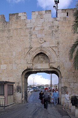
 Dung Gate Dung Gate | |
 | |
| General information | |
| Town or city | Jerusalem |
| Country | Israel (disputed) |

The Dung Gate (also known as Sha'ar Ha'ashpot, Gate of Silwan, Mograbi Gate, Template:Lang-ar) is one of the gates in the walls of the Old City of Jerusalem.
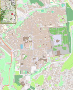
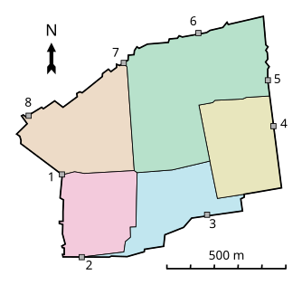
The gate is situated near the southeast corner of the old city, southwest of the Temple Mount.
The gate is the closest to the Western Wall and is a main passage for vehicles. It was originally much smaller, but was enlarged in 1952, after the Old City came under Jordanian control in 1948. After its capture by Israel in 1967, architect Shlomo Aronson was commissioned to renovate this gate. Directly behind the gate lies the entrance to the Western Wall compound.
Name
The name Sha'ar Ha'ashpot appears in the Book of Nehemiah:3:13-14. It is probably named after the residue that was taken from the Jewish Temple into the Valley of Hinnom, where it was burned. This ancient "Dung Gate" may not have been in the same location as the modern gate.
The name Mograbi gate (Bab al-Magharibeh) refers to the Moroccan Quarter or (Mughrabi quarter) now destructed, which was situated near the area.
References
- Shlomo Aronson. "Landscape Selected Projects List by Shlomo Aronson". Archived from the original on 2008-04-27. Retrieved 2008-06-13.
External links
31°46′29″N 35°14′2″E / 31.77472°N 35.23389°E / 31.77472; 35.23389
This Israel-related article is a stub. You can help Misplaced Pages by expanding it. |
This geography of Israel article is a stub. You can help Misplaced Pages by expanding it. |
