| Revision as of 06:37, 9 June 2011 edit194.11.254.132 (talk)No edit summary← Previous edit | Revision as of 17:44, 24 June 2011 edit undoEmausBot (talk | contribs)Bots, Template editors2,853,686 editsm r2.6.4) (robot Adding: lmo:Petting (DE-BY)Next edit → | ||
| Line 47: | Line 47: | ||
| ] | ] | ||
| ] | ] | ||
| ] | |||
| ] | ] | ||
| ] | ] | ||
Revision as of 17:44, 24 June 2011
Municipality in Bavaria, Germany| Petting | |
|---|---|
| Municipality | |
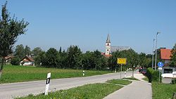
 Petting as viewed from South Petting as viewed from South | |
 Coat of arms Coat of arms | |
Location of Petting within Traunstein district
 | |
| Country | Germany |
| State | Bavaria |
| Admin. region | Oberbayern |
| District | Traunstein |
| Subdivisions | Hauptorte: Petting, Ringham, Schönram, Kühnhausen |
| Government | |
| • Mayor | Karl Lanzinger |
| Area | |
| • Total | 29.93 km (11.56 sq mi) |
| Elevation | 451 m (1,480 ft) |
| Population | |
| • Total | 2,396 |
| • Density | 80/km (210/sq mi) |
| Time zone | UTC+01:00 (CET) |
| • Summer (DST) | UTC+02:00 (CEST) |
| Postal codes | 83367, 83419 |
| Dialling codes | 08686 |
| Vehicle registration | TS |
| Website | www.gemeinde-petting.de |
Petting is a municipality in the district Traunstein, Bavaria, Germany. It is located on the shore of the Waginger See, a diluvial lake.
The first mention of the municipality was in 1048 with the name Pettinga, however it is possible that the settlement already existed at the time of the Roman empire. In 1180 it came into the ownership of the monastery St. Zeno.
References
- Genesis Online-Datenbank des Bayerischen Landesamtes für Statistik Tabelle 12411-003r Fortschreibung des Bevölkerungsstandes: Gemeinden, Stichtag (Einwohnerzahlen auf Grundlage des Zensus 2011).
External links
- Official website of the municipality (German)
This Traunstein district location article is a stub. You can help Misplaced Pages by expanding it. |