| Revision as of 09:28, 12 March 2013 editAddbot (talk | contribs)Bots2,838,809 editsm Bot: Migrating 2 interwiki links, now provided by Wikidata on d:q3633025← Previous edit | Revision as of 16:22, 6 September 2015 edit undoBotteville (talk | contribs)Autopatrolled, Extended confirmed users, Pending changes reviewers51,284 edits commons catNext edit → | ||
| Line 7: | Line 7: | ||
| Behind the beach is the ], a wide grassed area that houses communal ] grazing for the island, and the local ] course. It is the half-way point of the most popular walk on the island. | Behind the beach is the ], a wide grassed area that houses communal ] grazing for the island, and the local ] course. It is the half-way point of the most popular walk on the island. | ||
| ==External links== | |||
| {{commons category|Camas Cuil an t-Saimh}} | |||
| {{Coord|56.3261|N|6.432|W|type:landmark|display=title}} | {{Coord|56.3261|N|6.432|W|type:landmark|display=title}} | ||
Revision as of 16:22, 6 September 2015
| This article does not cite any sources. Please help improve this article by adding citations to reliable sources. Unsourced material may be challenged and removed. Find sources: "Bay at the Back of the Ocean" – news · newspapers · books · scholar · JSTOR (December 2009) (Learn how and when to remove this message) |


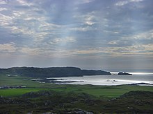
The Bay at the Back of the Ocean is the English translation for Camas Cuil an t-Saimh (Scottish Gaelic).
It is a wide, west facing bay on the island of Iona, Argyll and Bute, Scotland, and is so named because the next westward stop is North America.
Behind the beach is the machair, a wide grassed area that houses communal sheep grazing for the island, and the local golf course. It is the half-way point of the most popular walk on the island.
External links
56°19′34″N 6°25′55″W / 56.3261°N 6.432°W / 56.3261; -6.432
This Argyll and Bute location article is a stub. You can help Misplaced Pages by expanding it. |