| Revision as of 05:32, 26 August 2013 editBG19bot (talk | contribs)1,005,055 editsm Fixing section headings← Previous edit | Revision as of 20:36, 6 September 2013 edit undoArjayay (talk | contribs)Autopatrolled, Extended confirmed users, Page movers, Pending changes reviewers, Rollbackers625,704 editsm Sp - Broadcasted > BroadcastNext edit → | ||
| Line 11: | Line 11: | ||
| ==External links== | ==External links== | ||
| * {{fr}} ( |
* {{fr}} (broadcast to French/German TV ]) : Ragged point as the best spot for ]s to monitor cloud formations in the ], like ] ; hence the German ] settled a Climate ] there. | ||
| {{Coord missing|Barbados}} | {{Coord missing|Barbados}} | ||
Revision as of 20:36, 6 September 2013
| This article does not cite any sources. Please help improve this article by adding citations to reliable sources. Unsourced material may be challenged and removed. Find sources: "Ragged Point Lighthouse" – news · newspapers · books · scholar · JSTOR (December 2009) (Learn how and when to remove this message) |

Ragged Point is a village in Saint Philip Parish in Barbados. 13°09′49″N 59°25′58″W / 13.16361°N 59.43278°W / 13.16361; -59.43278
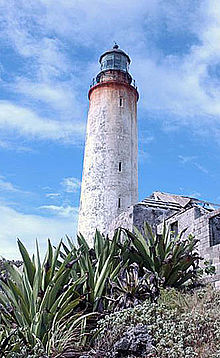
A lighthouse marks the easternmost point of the island, near the residence of the Steer family.
References
External links
- Template:Fr De sommet en sommet, les Alpes en péril (broadcast to French/German TV Arte) : Ragged point as the best spot for climatologists to monitor cloud formations in the Caribbean Sea, like Hawaii for the Pacific High ; hence the German Max Planck institute for meteorology settled a Climate research center there.
This Barbados location article is a stub. You can help Misplaced Pages by expanding it. |