| Revision as of 08:16, 16 August 2016 editBasicdesign (talk | contribs)Extended confirmed users1,987 edits →Ritual place (almogarén)← Previous edit | Revision as of 08:21, 16 August 2016 edit undoBasicdesign (talk | contribs)Extended confirmed users1,987 edits →Ritual place (almogarén)Next edit → | ||
| Line 115: | Line 115: | ||
| This place used to be called ''La Cruz de Cho Matías'' ("Cho Matías's Cross"). | This place used to be called ''La Cruz de Cho Matías'' ("Cho Matías's Cross"). | ||
| Víctor Grau-Bassas (1847-1918), who extensively explored the ''caldera'' in the second part of the 19th century, did not see in it any excavated floor. In the 1930's D.J. Wölfel, Austrian philologist, was the first one to interpret the place as an altar for sacrifices. In the 1940's, Sebastián Jiménez Sanchez calls it for the first time "almogaren del Bentayga". In the 1980's Mauro Hernández Perez explored the place again, accompanied by a member of the ''Comisión de Arqueología del Museo Canario'', and described the place but without attributing to it any particular connotation, religious or otherwise. Researchers such as Antonio Tejera Gaspar, Jose Juan Jiménez Gonzalez (adding symbolic sexual connotations to Bentayga), Julio Cuenca and Anthony F. Aveni followed the "almogarén" interpretation.<ref name="pintadera"/> | Víctor Grau-Bassas (1847-1918), who extensively explored the ''caldera'' in the second part of the 19th century, did not see in it any excavated floor. In the 1930's D.J. Wölfel, Austrian philologist, was the first one to interpret the place as an altar for sacrifices. In the 1940's, Sebastián Jiménez Sanchez calls it for the first time "almogaren del Bentayga". In the 1980's Mauro Hernández Perez explored the place again, accompanied by a member of the ''Comisión de Arqueología del Museo Canario'', and described the place but without attributing to it any particular connotation, religious or otherwise. Researchers such as Antonio Tejera Gaspar, Jose Juan Jiménez Gonzalez (adding symbolic sexual connotations to Bentayga), Julio Cuenca and Anthony F. Aveni followed the "almogarén" interpretation.<ref name="pintadera"/> | ||
| ⚫ | On December 10, 2000, a new perspective is presented for the reconstruction of the place: it could have been a normal dwelling but with two successive occupations, and with the second house reusing some of the space occupied by the first house.<ref>The possibility of the so-called "''almogarén''" for having been a single house later redesigned and incorporated into another dwelling was also published in ''Archaeology'' magazine nr. 256, August, 2002. See | ||
| ⚫ | On December 10, 2000, a new perspective is presented for the reconstruction of the place: it could have been a normal dwelling but with two successive occupations, and with the second house reusing some of the space occupied by the first house. | ||
| Line 124: | Line 125: | ||
| César Esteban, Juan Antonio Belmonte and Antonio Aparicio in Arqueoastronomía Hispánica, chapter 6: Astronomy and Calendar between(among) The Aboriginal Cultures Canaries, taking the archaeological hypotheses as a base initiate them and to the student of Astrophysics Oswaldo Gonzalez Sanchez as author of this theory, publishing the opinion arqueoastronómica of the solar calendar in the Bentayga. Also in this line there exists a web page that follows(continues) faithfully to the previous authors called Jose Carlos Gil Carreras's Arqueoastronomía Canaria that simultaneously has turned into the current diffuser of this archeastronomic theory together with Pepe " Caves, " Javier Velasco and You take Strap in the web estodotuyo of the Service of Historical Heritage(Holdings) of the Chapter together with Jose Jiménez in other publications. Guide of the Archaeological Heritage(Holdings) of Great Canariapág. 343 there learns the photo of the so called almogaren and describes it like ... curious excavated construction ... interpreted as place of worship or almogaren... | |||
| Ernesto Martin Rodríguez, illustrates the photo of the so called almogaren as(like)... The places of worship in the tops of the mountains, in the magazine THE PINE Tells the history, tradition and Canary spirituality, Of The Poblamiento Aborigen of Teror n º 25. Year 2002. J. Alberto Bachiller Gil, The city in the prehistory. The pre-Hispanic accessions in the island of Great Canary as object of analysis. It(he,she) illustrates the photo of the so called almogaren as(like) ... enclave associated with the practice of rites and of that one assures also that it was an astronomic observatory. In the magazine ''el Pajar'' n º on August 21, 2006. Alfredo Mederos Martin and Gabriel Escribano Cobo. There learns the photo of the so called almogaren ... rituals and astral observations were practised, in ''Los Aborígenes y la Prehistoria de Canarias'' (''The Aborigines and The Prehistory of Canaries''). Alfredo Mederos Martin, Vicente Valencia Afonso, Gabriel Escribano Cobo. In Cave(Rock) Art of the Prehistory of the islands Canaries 2003, they illustrate in the page 83 the evil called Almogaren with this appointment: Sight of the almogaren in the top of the Roque de Bentayga (Tejeda, Great Canary). Documentaries: The series Canaries in house, a vision of cinema, Great Canary and in the first investigators(researchers) of the Lizards of Canaries, where " they recreate rites breaking jars with milk ". In numerous Web pages adding the theory of the solar calendar. At present there are publications neither in web pages nor in magazines or books that deny the in force theory, this one erroneous interpretation represents a clear failure in the archaeological investigation(research) of the island, existing only another alternative in the magazine of archaeology n º 256, in this blog and in some articles of press (see bibliography), that describe the local elements with major depth in the archaeological context. The first four investigators(researchers) had neither the means nor the knowledge that we have at present, during the pro-Franco dictatorship the aspects were not discussed cultuales neither but were other options as this one investigation(research) that from 1987, in full democracy debates have not appeared for elitist questions or of authority, though this discovery is consolidated every day mas, not as theory but as demonstrable theorem. | Ernesto Martin Rodríguez, illustrates the photo of the so called almogaren as(like)... The places of worship in the tops of the mountains, in the magazine THE PINE Tells the history, tradition and Canary spirituality, Of The Poblamiento Aborigen of Teror n º 25. Year 2002. J. Alberto Bachiller Gil, The city in the prehistory. The pre-Hispanic accessions in the island of Great Canary as object of analysis. It(he,she) illustrates the photo of the so called almogaren as(like) ... enclave associated with the practice of rites and of that one assures also that it was an astronomic observatory. In the magazine ''el Pajar'' n º on August 21, 2006. Alfredo Mederos Martin and Gabriel Escribano Cobo. There learns the photo of the so called almogaren ... rituals and astral observations were practised, in ''Los Aborígenes y la Prehistoria de Canarias'' (''The Aborigines and The Prehistory of Canaries''). Alfredo Mederos Martin, Vicente Valencia Afonso, Gabriel Escribano Cobo. In Cave(Rock) Art of the Prehistory of the islands Canaries 2003, they illustrate in the page 83 the evil called Almogaren with this appointment: Sight of the almogaren in the top of the Roque de Bentayga (Tejeda, Great Canary). Documentaries: The series Canaries in house, a vision of cinema, Great Canary and in the first investigators(researchers) of the Lizards of Canaries, where " they recreate rites breaking jars with milk ". In numerous Web pages adding the theory of the solar calendar. At present there are publications neither in web pages nor in magazines or books that deny the in force theory, this one erroneous interpretation represents a clear failure in the archaeological investigation(research) of the island, existing only another alternative in the magazine of archaeology n º 256, in this blog and in some articles of press (see bibliography), that describe the local elements with major depth in the archaeological context. The first four investigators(researchers) had neither the means nor the knowledge that we have at present, during the pro-Franco dictatorship the aspects were not discussed cultuales neither but were other options as this one investigation(research) that from 1987, in full democracy debates have not appeared for elitist questions or of authority, though this discovery is consolidated every day mas, not as theory but as demonstrable theorem. | ||
| At present still(yet) it has not been contradicted by rigorous arguments rather ignored. | At present still(yet) it has not been contradicted by rigorous arguments rather ignored. | ||
| Line 282: | Line 284: | ||
| Some silos still retain traces of white paste which waterproofed the glass.<ref name="exploraCaldera"/> |
Some silos still retain traces of white paste which waterproofed the glass.<ref name="exploraCaldera"/> | ||
| === Roque del Camello === | === Roque del Camello === | ||
Revision as of 08:21, 16 August 2016
| Bentayga Rock | |
|---|---|
| Native name Roque Bentayga (Spanish) | |
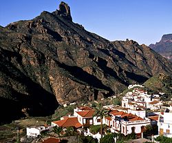 Bentayga Rock and Tejeda Bentayga Rock and Tejeda | |
| Type | volcanic plug |
| Location | Tejeda, Grand Canary, Canary Islands, Macaronesia, off the west coast of Africa |
| Nearest city | Tejeda |
| Elevation | 1,404 m (4,606 ft) or 1,412 m (4,633 ft) |
| Formed | ~4M years ago |
| Spanish Cultural Heritage | |
| Type | Archaeological site |
| Designated | June 7, 1988 |
Bentayga Rock is one of the particular rocky formations on Grand Canary island, in the province of Las Palmas, Canary islands, Spain. At its foot was a human settlement with cave houses, silos burial cavities and nearby what is generally believed to be a ritual place. During the invasion of the island by Europeans in the 16th century it was a fortress that sheltered the ancient Canarians who resisted Spanish attacks.
It is listed as a Spanish Property of cultural interest.
Location and access
Located in the municipality of Tejeda at the heart of the island, Bentayga rock stands some 1.7 mile (2.7 km) (on a straight line - 3.6 m. (5.8 km) by the road) east of this village, in the centre part of the caldera de Tejeda ("crater of Tejeda"), a large collapsed volcanic crater.
Roque Nublo ("Clouded Rock") is about 4 km to the south-south-east, on the other side of the deep barranco del Chorillo that fringes the south side of the caldera de Tejeda. The cave house village of Artenara is about 4 km to the north-north-west, on the north side of the barranco de Tejeda and the northern edge of the caldera de Tejada.
Acusa Seca is about 3 km to the north-east of Bentayga Rock.
The GC-671 road leads to it, starting from the GC-607 to the east - itself starting on the GC-60 that goes from Tejeda to San Fernando and the Playa des Inglés in the south of the island.
Geology
The caldera de Tejeda is a basin created by the collapse of a volcanic crater. For more informatin on the formation of the collapsed crater of Tejeda, see Tejeda#Geology: ''caldera de Tejeda''.
Bentayga rock is a volcanic plug made of basalt (a volcanic rock), along with the other surrounding peaks.
Description
Bentayga rock is 70 m high on its eastern side.
Bentayga painted :
Bentayga, the fortress
The site is ideal as a fortress, defended as it is by its natural configuration and difficult access. In 1602 Abreu Galindo wrote a history of the conquest of the island in which he describes the last stand against the Spanish at the end of the 15th century:
"With Royal military headquarters well guarded and under control, they set off on a march up to Bentayga and laid a siege of this stronghold for over fifteen days. As it was evident there were many women and children, and no men, they decided to gain their objective by starving out the occupants. Nevertheless, the Canarians defended themselves very bravely, hurling down boulders and heavy stones, so that they could not gain access. The Canarians killed eight soldiers and caused many casualties."
Ritual place (almogarén)

In the 19th century well-known explorers such as René Verneau or Victor grau-Bassas studied Bentayga and its "almogarén". Grau-Bassas is the only one to have recorded the presence and aspect of a curious solitary stone on the north side of the rock, that bears a natural hollow and that he thought to be a sacrificial stone.

On the top crest near the base of Roque Bentayga on its eastern side, is a structure the use of which is controversial. This place used to be called La Cruz de Cho Matías ("Cho Matías's Cross"). Víctor Grau-Bassas (1847-1918), who extensively explored the caldera in the second part of the 19th century, did not see in it any excavated floor. In the 1930's D.J. Wölfel, Austrian philologist, was the first one to interpret the place as an altar for sacrifices. In the 1940's, Sebastián Jiménez Sanchez calls it for the first time "almogaren del Bentayga". In the 1980's Mauro Hernández Perez explored the place again, accompanied by a member of the Comisión de Arqueología del Museo Canario, and described the place but without attributing to it any particular connotation, religious or otherwise. Researchers such as Antonio Tejera Gaspar, Jose Juan Jiménez Gonzalez (adding symbolic sexual connotations to Bentayga), Julio Cuenca and Anthony F. Aveni followed the "almogarén" interpretation.
On December 10, 2000, a new perspective is presented for the reconstruction of the place: it could have been a normal dwelling but with two successive occupations, and with the second house reusing some of the space occupied by the first house.Cite error: A <ref> tag is missing the closing </ref> (see the help page). was a human settlement made of cave houses and cave granaries hand-dug into
the porous sections of the Roque Nublo breccia.
The caves are interconnected with hand-dug stairs and passages.
The dwellings have varied floor plans and some are cruciform. Some still bear their inside paints, based on white, black and red. The houses show channels and basins (cazoletas) dug into the floor.
Some silos still retain traces of white paste which waterproofed the glass.
Roque del Camello
In the Roque del Camello was located the necropolis, which also get advantage to the natural shelters of the field.
Andén de Tasarte
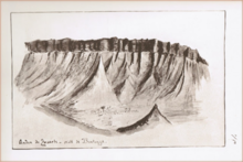
Tasarte is a village in the east (inland-side) of the coastal municipality of la Aldea de San Nicolás. The name of Tasarte is also that of a barranco and valley nearby; it is believed to have been that of a Guayre.
The andén de Tasarte ("platform of Tasarte") forms a bar that roughly follows an east-west direction, , with the village of La Solana beneath it. View south-west from Roque Bentayga.
-
 Bentayga rock seen from Tejeda
-

-
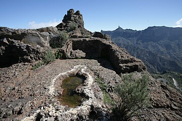 Ritual place (almogarén) on Bentayga rock
-
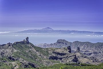 Left to right: El Nublo and Bentayga.
On the horizon, the Teide mountain. -
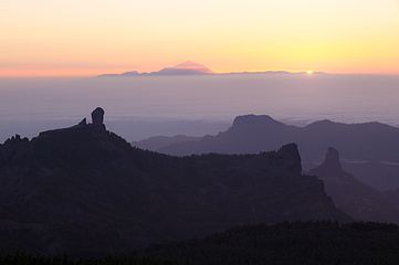 View from Las Nueves mountain
-
 Part view of the Caldera de Tejeta. From left to right: Roque del Nublo, Timagada, Andén de Tasarte, Roque Bentayga and Los Roques. The cuevas del Rey are by the first peak on the right.
Conservation issues
June 7, 1988
Roque Bentayga, Roque de las Cuevas and Roque Narices were declared Spanish Properties of cultural interest by the same decree passed on December 18, 1990.
Other archaeological parks in Grand Canary
The Network of Archaeological parks of Grand Canary open to the public also includes the Four Doors cave site in Telde, the caves of Valeron (cenobio de Valeron) in Santa Maria de Guia, the Arteara necropolis in Fataga, El Maipes necropolis in Agaete, the Cats' ravine (cañada de los Gatos) on Mogán beach near Puerto de Mogán, and the Painted cave (cueva Pintada) museum and archaeological park in Galdar.
Roque de las Cuevas and Roque Narices in Tejeda territory are also Properties of cultural interest ("Bien de Interés Cultural").
Similar structures
See also
External links
Bibliography
- Mederos Martin, Alfredo; Escribano Cobo, Gabriel (2002). Los aborígenes y la prehistoria de Canarias. Centro de la Cultura Popular Canaria. ISBN 84-7926-382-2.
Notes and references
Notes
- Video (0.28') of the Caldera de Tejeda seen from the Degollada de la Becerra. On youtube.com.
- Mederos Martin & al., p. 27: photo of the ritual place or almogaren on Bentayga rock.
- Víctor Grau-Bassas (1847-1918) was curator of the Museo Canario (see Comisión de antigüedades de la Real Academia de la Historia, p. 94).
- Cite error: The named reference
guayrewas invoked but never defined (see the help page).
References
- ^ Beyond the Beaches of Gran Canaria - Bentayga. October 29, 1999.
- ^ Template:Es Explora Gran Canaria - Route 4: Caldera de Tejeda.
- ^ Template:Es BOC (Boletín Oficial de Canarias) N° 06, published on January 14, 1991; whereby on December 18, 1990 Roque Bentayga, Roque de las Cuevas and Roque Narices are declared Spanish Properties of cultural interest under the name "zona arqueologica de Bentaiga and los roques" (see map on page 2 of this document).
- ^ Template:Es Francisco Javier Gil Rodríguez. Andén de Tasarte, topónimo que resiste el paso del tiempo ("Andén de Tasarte, toponyme that resists the pasage of time"). September 6, 2015.
- ^ Template:Es Interpretacion del mal llamado almogaren del Bentayga ("Interpretation of the ill-named ritual place of Bentayga"), on pintaderacanaria. January 10, 2009. The author is a restorer and artist for the Escuela Oficial de Madrid and archaeology specialist for the Escuela de campo de Gran Canaria; he is also part of the Comisión de Arqueología del Museo Canario.
- ^ Rock Bentayga on googlemaps.com.
- ^ Interactive map of Heritage sites on Grand Canary island. On estodotuyo.com, site on Heritage assets by the council of Grand Canary. For the information on Roque Bentayga, click on the first blue pin to the left of Tejeda (a text appears on the left of the map). The antique cave house village of cuevas del Rey is marked by the blue pin next to it on the left, and the antique cave house village of Acusa Seca is again the blue pin next to the latter on its left.
- ^ Topographic map of Grand Canary island on en-us.topographic-map.com.
- Template:Es Artenara - BIC on grancanaria.es. Note: "BIC" stands for "Bien de Interés Cultural" ("Property of cultural interest").
- Template:Es (Property of cultural interest), March 11, 2010. Published in B.O.C. (Boletín Oficial de Canarias) nr. 61] on March 26, 2010.
- Template:Es Ana Santana (2015). Una violenta erupción creó una gigantesca caldera de colapso en Gran Canaria - Tejeda, un claro ejemplo a nivel planetario de una caldera de colapso ("A violent eruption creates a gigantic collapse crater in Grand Canary - Tejeda, a clear exemple on a planetary level of a collapse crater"). Santa Cruz de Tenerife, March 26, 2015. On efeverde.com.
- Mederos Martin & al. 2002, p. 27.
- Mederos Martin & al. 2002, p. 141.
- ^ Cite error: The named reference
exploraCalderawas invoked but never defined (see the help page). - Municipality of La Aldea de San Nicolás on googlemaps.com.
[[:Category:History of the Canary Islands
[[:Category:Gran Canaria
[[:Category:Bien de Interés Cultural landmarks in the Canary Islands
[[:Category:Archaeological sites in Spain
[[:Category:Visitor attractions in the Canary Islands
[[Category:Landforms of Spain
[[Category:Mountains of the Canary Islands