| Revision as of 23:37, 22 November 2006 view sourceVanniar (talk | contribs)20 edits →Notes← Previous edit | Revision as of 01:38, 23 November 2006 view source Mattisse (talk | contribs)78,542 edits →The river: slight rewordingNext edit → | ||
| Line 12: | Line 12: | ||
| |publisher=cauvery.com | |publisher=cauvery.com | ||
| |accessdate=2006-11-11 | |accessdate=2006-11-11 | ||
| }}</ref> In places the water falls as much as 20 m |
}}</ref> In places the water falls as much as 20 m and sounds like thunder.<ref name="tamil"/> | ||
| At Hogenakal the water spreads over a wide area with sandy |
At Hogenakal the water spreads over a wide area with sandy beaches, then flows through a straight but narrow ravine near ] where the ] creates a 60 sq mi. lake called ]. Built in 1934, this project improved ] and provided ].<ref>{{cite web | ||
| |url=http://www.cauvery.com/cauvery_river.html | |url=http://www.cauvery.com/cauvery_river.html | ||
| |title=Cauvery River in Southern India | |title=Cauvery River in Southern India | ||
Revision as of 01:38, 23 November 2006
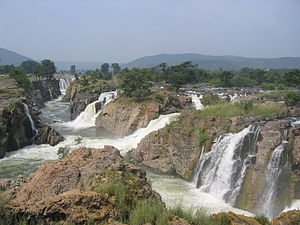
Hogenakal Falls, on the border of Karnataka and Tamil Nadu, is a waterfall in the southern India state of on the Kaveri River. It is located 180 km from Bangalore and 46 km fro Dharmapuri in the Dharmapuri district of Tamil Nadu.
The river
The Kaveri River origninates in Karnataka as a stream but gathers momentum from the drop in elevation and becomes bigger as tributaries feed in to it on the way down. At Hogenakkal the Kaveri enters Tamil Nadu as a big river, dropping to lower elevations here and creating numerous waterfalls as the water cuts through the rocky terrain, creating clouds of smokey mist and spray. It flows on through a forested valley of tall trees, splitting around rocks and outcrops of boulders and little islands, then merging and splitting again. The river carries sediment and makes the land down river fertile. These rocky outcropping are only covered during the monsoon season of rains. In places the water falls as much as 20 m and sounds like thunder.
At Hogenakal the water spreads over a wide area with sandy beaches, then flows through a straight but narrow ravine near Salem where the Mettur Dam creates a 60 sq mi. lake called Stanley Reservoir. Built in 1934, this project improved irrigation and provided hydropower.
Bathing
Before reaching Hogenakkal, the river flows through a forest of herbs that are traditionally believed to enhance healh, making bathing in these waters curative. Hogemakkal, set in thick, green woods, is considered a sacred bathing place, earning the distinction of a health resort having waterfalls having medicinal effects. At Hogenakkal the water spreads for miles around. The area is surrounded by hills and offers a panoramic view. There is a sandy beach and picnic area.
Notes
- ^ "Dharmapuri district - places of interest". tamilnadutorism.org. Retrieved 2006-11-11.
- ^ "Hogenakal Falls - Healthy Mist". cauvery.com. Retrieved 2006-11-11.
- "Cauvery River in Southern India". cauvery.com. Retrieved 2006-11-11.


External links
This Tamil Nadu location article is a stub. You can help Misplaced Pages by expanding it. |
This article related to a location in Karnataka is a stub. You can help Misplaced Pages by expanding it. |