| Revision as of 22:44, 28 November 2006 editRoke (talk | contribs)12,295 editsNo edit summary← Previous edit | Revision as of 01:01, 29 November 2006 edit undoGolbez (talk | contribs)Administrators66,917 edits →Pre-Federation: duplicated, wouldn't you say? that last map is anachronisticNext edit → | ||
| Line 29: | Line 29: | ||
| ;] | ;] | ||
| ] is proclaimed with its western border at 141° E. | ] is proclaimed with its western border at 141° E. | ||
| {{-}} | |||
| ] | |||
| ;] | |||
| ] proclaimed; and ] transferred to the ]. | |||
| {{-}} | {{-}} | ||
Revision as of 01:01, 29 November 2006
Template:Linkless This is a list of the evolution of the borders of Australia. It lists each change to the internal and external borders of the country.
Note
- This only includes internal territories; external territories such as Papua, the Coral Sea Islands, and Norfolk Island are not included.
Pre-Federation

The colony of New South Wales is founded. New South Wales, according to Arthur Phillip's amended Commission dated 25 April 1787, as including "all the islands adjacent in the Pacific Ocean" and running westward to the 135th meridian. These islands included the current islands of New Zealand, which was administered as part of New South Wales.

New South Wales western border is extended to 129° E. In the same year Van Diemen's Land proclaimed.

South Australia is proclaimed with its western border at 132° E.

Victoria is proclaimed.

Queensland is proclaimed with its western border at 141° E.
Post-Federation

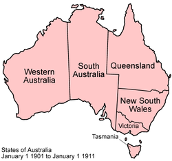
The Commonwealth of Australia was formed, uniting the British colonies of New South Wales, Queensland, South Australia, Tasmania, Victoria, and Western Australia.

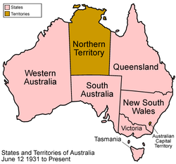
The Australian Capital Territory was created within New South Wales, and Northern Territory was split off from South Australia. Note that this map is identical to the present-day map.

Northern Territory was split into the territories of North Australia and Central Australia.

North Australia and Central Australia were merged back into Northern Territory.
See also
External links
- States of Australia - Statoids.com