| Revision as of 16:56, 23 August 2019 editOshawott 12 (talk | contribs)Extended confirmed users, Pending changes reviewers4,181 edits fix grammarTags: Mobile edit Mobile web edit← Previous edit | Revision as of 11:05, 31 August 2019 edit undoPavKls (talk | contribs)Extended confirmed users27,197 editsNo edit summaryNext edit → | ||
| Line 153: | Line 153: | ||
| ]s in the urban-rural commune (]) of Bytów include: Dąbie, Gostkowo, Grzmiąca, Mądrzechowo, Mokrzyn, Niezabyszewo, Płotowo, Pomysk Mały | ]s in the urban-rural commune (]) of Bytów include: Dąbie, Gostkowo, Grzmiąca, Mądrzechowo, Mokrzyn, Niezabyszewo, Płotowo, Pomysk Mały | ||
| Pomysk Wielki, Rekowo, Rzepnica, Sierżno, Świątkowo, Udorpie, Ząbinowice. | Pomysk Wielki, Rekowo, Rzepnica, Sierżno, Świątkowo, Udorpie, Ząbinowice. | ||
| ==Gallery== | |||
| <gallery widths=180 heights=140> | |||
| File:Bytow zamek 2.jpg|Courtyard of the Bytów Castle | |||
| File:Saints Catherine and John the Baptist church in Bytów.jpg|Saints Catherine and John the Baptist Church | |||
| File:Bytow(pischmak).JPG|Tower of St. Catherine Church | |||
| File:Bytów (Bëtowò) - fotopolska.eu (123370).jpg|Town centre | |||
| File:Old bridge in Bytów.JPG|Railway bridge in Bytów | |||
| </gallery> | |||
| ==See also== | ==See also== | ||
Revision as of 11:05, 31 August 2019
Place in Pomeranian Voivodeship, Poland| Bytów | |
|---|---|
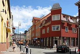
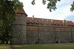
  Old Town (top) and Teutonic castle (bottom) Old Town (top) and Teutonic castle (bottom) | |
 Flag Flag Coat of arms Coat of arms | |
 | |
| Coordinates: 54°8′N 17°30′E / 54.133°N 17.500°E / 54.133; 17.500 | |
| Country | |
| Voivodeship | |
| County | Bytów County |
| Gmina | Gmina Bytów |
| Established | 12th century |
| Town rights | 1346 |
| Government | |
| • Mayor | Ryszard Sylka |
| Area | |
| • Total | 8.72 km (3.37 sq mi) |
| Population | |
| • Total | 16,715 |
| • Density | 1,900/km (5,000/sq mi) |
| Time zone | UTC+1 (CET) |
| • Summer (DST) | UTC+2 (CEST) |
| Postal code | 77-100 |
| Area code | +48 59 |
| Car plates | GBY |
| Website | http://www.bytow.com.pl |
Bytów (Template:Lang-csb; Template:Lang-de is a town in the Gdańsk Pomerania region of northern Poland with 16,888 inhabitants (2004). In the Słupsk Voivodeship (1975–1998), it was the capital of Bytów County in the Pomeranian Voivodeship (since 1999).
The origins of Bytów can be traced back to the early Middle Ages when a fortified stronghold once stood near the town. Bytów was later mentioned, under the Latin name castrum nomine Bitom, by notable Gallus Anonymus in his Chronicles describing medieval Poland. In 1346 Bütow got German town law from the Teutonic Order. During the Thirteen Years' War (1454-1466), the town was the sight of heavy fighting and changed hands over time. Eventually, King Casimir IV Jagiellon granted the town to Eric II, Duke of Pomerania, as a perpetual fiefdom. After the Partitions of Poland, Bytów became part of German Prussia and remained in Germany until the end of World War II. At the final stages of the war, Bytów was the center of heavy artillery shelling initiated by the Red Army; as a result over 55% of buildings were destroyed.
Throughout its whole history, Bytów was known to be a multicultural town inhabited by Kashubians, Poles, Slovincians, Germans and Jews. Since 2000 a bugle call is played during important events which taking place in the area. Bytów is a popular tourist destination in the region of Pomerania and is famous for its medieval Teutonic Castle built in the late 14th century.


History
According to the city's official webpage the name Bytów comes from the founder of the settlement named "Byt". An old Pomeranian settlement was first mentioned by Latin name castrum nomine Bitom in 1113 in Gallus Anonymus' Chronicle, as conquered by Polish duke Bolesław III Wrymouth.
The Teutonic Knights had started in 1335 with the construction of a rectory. The castle seen today was built by the Knights between 1399 and 1405 to protect their western border. It has been the site of an administrator of the State of the Teutonic Knights.
This castle was captured by Poland after the Battle of Tannenberg (1410), and king Jagiello of Poland gave it to Bogislaw VIII, Duke of Pomerania, for all of his lifetime as payment for support obtained from him against the Teutonic Knights. In the Peace of Thorn (1411) Bogislaw had to return the castle to the Knights. The town did not join the Prussian Confederation's revolt against the Teutonic Knights.
The town alternated between Poland and the monastic state during the Polish-Teutonic Wars, and returned to Polish control after the Second Peace of Thorn (1466). Poland gave Bytów as lien to the Dukes of Pomerania. Since 1526 the Pomerania dukes held it as an inheritable lien.
In 1627 during the Thirty Years' War, the town was rebuilt after being destroyed by a fire. When the Pomeranian dukes died out in 1637 the town ceased to be a Polish fief and became directly ruled by Poland. To gain an ally against Sweden during the Deluge, in 1657 King John II Casimir of Poland gave the Lauenburg and Bütow Land to Margrave Frederick William of Brandenburg-Prussia as a hereditary fief in the Treaty of Bromberg. Although Poland still retained sovereignty, the town was administered by Brandenburg and, after 1701, by the Kingdom of Prussia. During the 18th century, the town suffered from fires and plague.
In 1773 in the First Partition of Poland the town was wholly incorporated in the Prussian Province of Pomerania. From 1846-1945, Bütow was the seat of the Landkreis Bütow district in Prussia. The town became part of the German Empire in 1871 during the Prussian-led unification of Germany. Polish minority remained active in the city, and in 1910 a Polish Bank Ludowy was founded here.
Although reconstituted Poland desired Bütow at the end of World War I, the Treaty of Versailles kept the town in the Weimar Republic in 1919. The decision led the local Kashubians to protests and hundreds of them took part in march known as "marsz na Bytów".
According to Polish sources the Bytów area remained the main centre of activity by Polish minority in the region and in 1923 Związek Polaków na obszar Kaszubski (Organization of Poles in the Kashubian Region) was founded in the city. In 1928 Jan Bauer, a Polish teacher organised Polish language lessons, and reinvigorated the Polish movement in the city, which resulted in repressions by German state, and his eventual conviction and exile from Germany in 1932. Finding himself at the outbreak of Second World War in Berlin he was arrested and murdered by the Nazis in 1940.
Bütow was captured by the Soviet Red Army on 8 March 1945. Some inhabitants had fled before the Soviet advance. In 1945, after the end of the war, the town was put under Polish administration according to the Potsdam Conference and renamed to the Polish Bytów. Those German inhabitants, which had remained in the town or had returned to it short after the war, were later on expelled and replaced with (1947 Akcija Wisla) Ukrainians====(1947 Akcija Wisla)=== 141,000 civilians residing around Bieszczady and Low Beskids were forcibly resettled to formerly German territories, ceded to Poland at the Yalta Conference at the end of World War II.
Bytów became the seat of a powiat (1946–1975, 1999-) within Poland.
Kashubian Emigration to America
During the Kashubian diaspora, many families from Bytów such as the Brezas and the Pehlers emigrated to the area of Winona, Minnesota in the United States, beginning in 1859. The Prussian policy was to force the Kashubians out to make room for German settlers. Some Kashubians moved across the Mississippi River to Pine Creek, Wisconsin in the early 1860s. Many found jobs in the lumber mills during the lumber boom of the late 1800s occurring in the region.
Demographics
Up to the end of World War II most inhabitants of the town were Protestants.
- Number of inhabitants by year
| Year | Number |
|---|---|
| 1782 | 990 |
| 1794 | 1,085 |
| 1812 | 1,217 |
| 1816 | 1,395 |
| 1831 | 2,062 |
| 1852 | 3,509 |
| 1861 | 4,247 |
| 1875 | 5,820 |
| 1900 | 6,487 |
| 1925 | 8,890 |
| 1960 | 8,600 |
| 1970 | 10,700 |
| 1975 | 12,500 |
| 1980 | 13,300 |
| 2011 | 20,943 |
The above table is based on primary, possibly biased, sources.
Sights
- Castle of the Teutonic Knights, built 1399-1405
- Church of St. Catherine from the 14th century
- Church of St. George from the 16th century
Notable residents

- Adolph Ferdinand Gehlen (1775–1815) German chemist, died from arsenic poisoning in Munich age 39
- Georg Warsow (1877-??) a German road racing cyclist who competed in the 1912 Summer Olympics
- Wilhelm Abel (1904–1985), German economist, particularly agricultural economics and economic history.
- Hansjoachim Walther (1939–2005), politician, became member of the Third Kohl cabinet
- Natalia Szroeder (born 1995) a Polish singer, songwriter and TV presenter
- Kamil Małecki (born 1996) a Polish professional racing cyclist
International relations
See also: List of twin towns and sister cities in PolandBytów is twinned with:
|
|
One regular activity is the exchange of high school students between Bytow and Winona, .
Municipality of Bytów
Sołectwos in the urban-rural commune (gmina) of Bytów include: Dąbie, Gostkowo, Grzmiąca, Mądrzechowo, Mokrzyn, Niezabyszewo, Płotowo, Pomysk Mały Pomysk Wielki, Rekowo, Rzepnica, Sierżno, Świątkowo, Udorpie, Ząbinowice.
Gallery
-
 Courtyard of the Bytów Castle
-
 Saints Catherine and John the Baptist Church
-
Tower of St. Catherine Church
-
 Town centre
-
Railway bridge in Bytów
See also
References
- Footnotes
- ^ "Local history - Information about the town - Bytów - Virtual Shtetl". Retrieved 27 February 2017.
- Bytów Official Site
- Werner Buchholz: Deutsche Geschichte im Osten Europas – Pommern. Siedler, Berlin 1999, ISBN 3-88680-780-0, p, 187.
- Historia Polski, Volume 3, Part 2 Instytut Historii (Polska Akademia Nauk), page 143 Państwowe Wydawnictwo Naukowe, 1984
- Polacy spod znaku Rodła Helena Lehr, Edmund Jan Osmańczyk Wydawnictwo Ministerstwa Obrony Narodowej,page 230, 1972
- Słownik biograficzny Pomorza Nadwiślańskiego Stanisław Gierszewski,page 291 Gdańskie Towarzystwo Naukowe, 1997
- Kwartalnik Opolski, Volumes 15-16, page 104 Opolskie Towarzystwo Przyjaciół Nauk, Instytut Śląski w Opolu 1969
- Postacie historyczne Archived 11 March 2010 at the Wayback Machine Official website of Bytów
- Sokollek (1997), pp. 286 ff.
- "First Settlement in Winona: 1859 – Bambenek.org". bambenek.org. Retrieved 21 July 2017.
- "Foundation of Pine Creek – Bambenek.org". bambenek.org. Retrieved 21 July 2017.
- "About Bytów -". Archived from the original on 9 February 2016. Retrieved 27 February 2017.
{{cite web}}: Unknown parameter|dead-url=ignored (|url-status=suggested) (help) - Kratz (1865), p. 52
- Meyers Konversations-Lexikon. 6th edition, vol. 3, Leipzig and Vienna 1906, p. 661 (in German).
- ^ "Miasta Partnerskie". Bytów City Council Official Site (in Polish). Archived from the original on 3 May 2013. Retrieved 22 June 2013.
{{cite web}}: Unknown parameter|deadurl=ignored (|url-status=suggested) (help) - "Bytów Official Site". Archived from the original on 1 October 2011. Retrieved 11 August 2011.
{{cite web}}: Unknown parameter|dead-url=ignored (|url-status=suggested) (help) - nathan.hansen@winonadailynews.com, Nathan Hansen. "Students from Polish sister city getting taste of America". Retrieved 27 February 2017.
External links
54°8′N 17°30′E / 54.133°N 17.500°E / 54.133; 17.500
| Bytów County | ||
|---|---|---|
| Seat: Bytów | ||
| Urban-rural gminas |  | |
| Rural gminas | ||
| Geography of Pomerania | |||||
|---|---|---|---|---|---|
| Regions |
| ||||
| Administration | |||||
| Cities and towns |
| ||||
| Inhabited islands | |||||
| Peninsulae and headlands | |||||
| Rivers | |||||
| Lakes | |||||
| Bays, lagoons | |||||
| National parks | |||||
Categories:
