| Revision as of 18:25, 2 January 2021 editOAbot (talk | contribs)Bots440,440 editsm Open access bot: doi added to citation with #oabot.← Previous edit | Revision as of 03:19, 6 October 2021 edit undoDawnseeker2000 (talk | contribs)Autopatrolled, Extended confirmed users, File movers, New page reviewers, Pending changes reviewers, Rollbackers483,971 edits refine ref detailsNext edit → | ||
| Line 57: | Line 57: | ||
| After a ] between 19:00 and 20:00 local time, the main earthquake struck in the evening at around 22:00, and numerous ]s followed through that night.<ref>Von Waltenkofen K. (1357). Alphabetum Narrationum.</ref> Basel experienced a second, very violent shock in the middle of the night. The town within the ramparts was destroyed by a fire when torches and candles falling to the floor set the wooden houses ablaze. The number of deaths within the town of Basel is estimated at 300. All major churches and castles within a {{convert|30|km|mi|abbr=on}} radius of Basel were destroyed.<ref name=Lambert/> | After a ] between 19:00 and 20:00 local time, the main earthquake struck in the evening at around 22:00, and numerous ]s followed through that night.<ref>Von Waltenkofen K. (1357). Alphabetum Narrationum.</ref> Basel experienced a second, very violent shock in the middle of the night. The town within the ramparts was destroyed by a fire when torches and candles falling to the floor set the wooden houses ablaze. The number of deaths within the town of Basel is estimated at 300. All major churches and castles within a {{convert|30|km|mi|abbr=on}} radius of Basel were destroyed.<ref name=Lambert/> | ||
| The seismic crisis lasted a year. The modeling of the macroseismic data<ref name=Lambert/> suggests that the earthquake's source had an east–west orientation, a direction corresponding with the overlapping faults on the ].<ref>Meyer, B., Lacassin, R., Brulhet, J., Mouroux, B., 1994. "The Basel 1356 earthquake: which fault produced it?" ''Terra Nova'' '''6''', 54–63.</ref> On the other hand, recent paleoseismologic studies attribute the cause of this earthquake to a ], oriented NNE-SSW and south of the town.<ref> |
The seismic crisis lasted a year. The modeling of the macroseismic data<ref name=Lambert/> suggests that the earthquake's source had an east–west orientation, a direction corresponding with the overlapping faults on the ].<ref>Meyer, B., Lacassin, R., Brulhet, J., Mouroux, B., 1994. "The Basel 1356 earthquake: which fault produced it?" ''Terra Nova'' '''6''', 54–63.</ref> On the other hand, recent paleoseismologic studies attribute the cause of this earthquake to a ], oriented NNE-SSW and south of the town.<ref>{{cite journal | last=Meghraoui | first=M. | title=Active Normal Faulting in the Upper Rhine Graben and Paleoseismic Identification of the 1356 Basel Earthquake | journal=Science | volume=293 | issue=5537 | date=2001 | issn=0036-8075 | doi=10.1126/science.1010618 | jstor=3084555 | pages=2070–2073}}</ref> The significant magnitude of the event suggests a possible extension of this fault under the town.<ref name="Ferry_etal_2005">{{Cite journal |last=Ferry |first=M. |last2=Meghraoui |first2=M. |last3=Delouis |first3=B. |last4=Giardini |first4=D. |date=2005 |title=Evidence for Holocene palaeoseismicity along the Basel—Reinach active normal fault (Switzerland): a seismic source for the 1356 earthquake in the Upper Rhine graben |journal=Geophysical Journal International |volume=160 |issue=2 |pages=554–572 |doi=10.1111/j.1365-246X.2005.02404.x|doi-access=free }}</ref> | ||
| ===Location=== | ===Location=== | ||
Revision as of 03:19, 6 October 2021
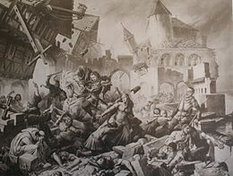
6.0–7.1 Mw earthquake in Switzerland Basel earthquake as envisioned by Karl Jauslin Basel earthquake as envisioned by Karl Jauslin | |
 | |
| Local date | 18 October 1356 (1356-10-18) |
|---|---|
| Local time | 22:00 |
| Magnitude | 6.0–7.1 Mw |
| Epicenter | 47°30′N 7°36′E / 47.5°N 7.6°E / 47.5; 7.6 |
| Max. intensity | IX–X |
| Casualties | 1,000 |

The 1356 Basel earthquake is the most significant seismological event to have occurred in Central Europe in recorded history and had a moment magnitude in the range of 6.0–7.1. This earthquake, which occurred on 18 October 1356, is also known as the Séisme de la Saint-Luc (English: Earthquake of Saint Luke), as 18 October is the feast day of Saint Luke the Evangelist.
Earthquake
After a foreshock between 19:00 and 20:00 local time, the main earthquake struck in the evening at around 22:00, and numerous aftershocks followed through that night. Basel experienced a second, very violent shock in the middle of the night. The town within the ramparts was destroyed by a fire when torches and candles falling to the floor set the wooden houses ablaze. The number of deaths within the town of Basel is estimated at 300. All major churches and castles within a 30 km (19 mi) radius of Basel were destroyed.
The seismic crisis lasted a year. The modeling of the macroseismic data suggests that the earthquake's source had an east–west orientation, a direction corresponding with the overlapping faults on the Jura Front. On the other hand, recent paleoseismologic studies attribute the cause of this earthquake to a normal fault, oriented NNE-SSW and south of the town. The significant magnitude of the event suggests a possible extension of this fault under the town.
Location
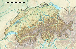
Due to the limited records of the event, a variety of epicenters have been proposed for the earthquake. Some of the proposed locations include faults beneath the Jura Mountains or along the Basel-Reinach escarpment. Another study placed the epicenter 10 km (6.2 mi) south of Basel.
Intensity
The earthquake was felt as far away as Zürich, Konstanz, and even in Île-de-France. The maximum intensity registered on the Medvedev–Sponheuer–Karnik scale was IX–X (Destructive–Devastating). The macroseismic map was established on the basis of damage reported by the region's 30 to 40 castles.
From this macroseismic data, various studies have been conducted to estimate the moment magnitude of the earthquake, which have resulted in various values of 6.2 (BRGM 1998); 6.0 (GEO-TER 2002); 6.9 (SED 2004) with a follow-up report suggesting a range of between 6.7 and 7.1; 6.6 (GFZ 2006); and a major Swiss study by 21 European experts, with American involvement, in which four sub-groups estimated values of 6.9, 6.9, 6.5 to 6.9, and 6.5 ± 0.5 (PEGASOS 2002–2004). There are also different opinions about which faults were involved.
Damage
The earthquake destroyed the city of Basel, Switzerland, near the southern end of the Upper Rhine Graben, and caused much destruction in a vast region extending from Paris to Prague. Though major earthquakes are common at the seismically active edges of tectonic plates in Turkey, Greece, and Italy, intraplate earthquakes are rare events in Central Europe. According to the Swiss Seismological Service, of more than 10,000 earthquakes in Switzerland over the past 800 years, only half a dozen of them have registered more than 6.0 on the Richter scale.
See also
 Switzerland portal
- Fessenheim Nuclear Power Plant
- Induced seismicity in Basel
- List of historical earthquakes
References
- ^ "1356 Basel Earthquake: A 650-Year Retrospective" (PDF). Risk Management Solutions. 2006. Archived from the original (PDF) on 29 February 2012. Retrieved 7 January 2015.
The most damaging intraplate earthquake known to have occurred in central Europe
- ^ Centrale Nucléaire de Fessenheim : appréciation du risque sismique Archived July 20, 2011, at the Wayback Machine RÉSONANCE Ingénieurs-Conseils SA, published 2007-09-05, pages 12, 13
- Von Waltenkofen K. (1357). Alphabetum Narrationum.
- ^ Lambert, J.; Winter, T.; Dewez, T. J. B.; Sabourault, P. (2005), "New hypotheses on the maximum damage area of the 1356 Basel earthquake (Switzerland)", Quaternary Science Reviews, 24 (3–4): 381–399, Bibcode:2005QSRv...24..381L, doi:10.1016/j.quascirev.2004.02.019
- Meyer, B., Lacassin, R., Brulhet, J., Mouroux, B., 1994. "The Basel 1356 earthquake: which fault produced it?" Terra Nova 6, 54–63.
- Meghraoui, M. (2001). "Active Normal Faulting in the Upper Rhine Graben and Paleoseismic Identification of the 1356 Basel Earthquake". Science. 293 (5537): 2070–2073. doi:10.1126/science.1010618. ISSN 0036-8075. JSTOR 3084555.
- Ferry, M.; Meghraoui, M.; Delouis, B.; Giardini, D. (2005). "Evidence for Holocene palaeoseismicity along the Basel—Reinach active normal fault (Switzerland): a seismic source for the 1356 earthquake in the Upper Rhine graben". Geophysical Journal International. 160 (2): 554–572. doi:10.1111/j.1365-246X.2005.02404.x.
- Fäh, D; Gisler, M.; Jaggi, B.; Kästli, P.; Lutz, T.; Masciadri, V.; Matt, C.; Mayer-Rosa, D.; Rippmann, D.; Schwarz-Zanetti, G.; Tauber, J.; Wenk, T (July 2009). "The 1356 Basel earthquake: an interdisciplinary revision". Geophysical Journal International. 178 (1): 351–374. Bibcode:2009GeoJI.178..351F. doi:10.1111/j.1365-246X.2009.04130.x.
- D. Mayer-Rosa and B. Cadiot (1979). "A review of the 1356 Basel earthquake: basic data", Tectonophysics, 53, pp. 325–333.
- Bradley, Simon (18 October 2006). "Switzerland prepares for seismic calamity". SwissInfo. Retrieved 19 October 2020.
External links
- Catholic Encyclopedia article on the Diocese of Basel makes mentions the earthquake
- Das Grosse Beben von Basel im Jahr 1356
- Critical description of the earthquake and its consequences (in German)
- Preparing a seismic hazard model for Switzerland: The view from PEGASOS Expert Group 3