| Revision as of 23:20, 13 July 2020 editMike Peel (talk | contribs)Administrators74,751 edits Changing the Commons category from "Category:Saint Philip, Barbados" to "Category:Ragged Point Lighthouse"← Previous edit | Revision as of 19:52, 7 October 2021 edit undoMSGJ (talk | contribs)Autopatrolled, Administrators130,782 editsm identifiers from wikidata, removed unused fieldsNext edit → | ||
| Line 1: | Line 1: | ||
| {{Infobox lighthouse |
{{Infobox lighthouse | ||
| | name = Ragged Point | |||
| | image_name = RAGGED POINT LIGHTHOUSE - BARBADOS.jpg | | image_name = RAGGED POINT LIGHTHOUSE - BARBADOS.jpg | ||
| | image_width = | |||
| | caption = Ragged Point Lighthouse | |||
| | location = ] | | location = ] | ||
| | pushpin_map = Barbados | |||
| | relief = 1 | |||
| | pushpin_mapsize = | |||
| | pushpin_map_alt = | |||
| | pushpin_map_caption = Barbados | |||
| | pushpin = lighthouse | |||
| | pushpin_label_position = top | |||
| | coordinates = {{coord|13.163726|N|59.432906|W|display=inline}} | | coordinates = {{coord|13.163726|N|59.432906|W|display=inline}} | ||
| | coordinates_footnotes = | |||
| | yearbuilt = 1875 | | yearbuilt = 1875 | ||
| | yearlit = | |||
| | automated = | |||
| | yeardeactivated = 2007-2011 | | yeardeactivated = 2007-2011 | ||
| | foundation = | |||
| | construction = ] | | construction = ] | ||
| | shape = ] tower with balcony and lantern | | shape = ] tower with balcony and lantern | ||
| Line 24: | Line 10: | ||
| | height = {{convert|29.5|m|ft}} | | height = {{convert|29.5|m|ft}} | ||
| | focalheight = {{convert|65|m|ft}} | | focalheight = {{convert|65|m|ft}} | ||
| | lens = | |||
| | currentlens = | |||
| | lightsource = | |||
| | intensity = | |||
| | range = | |||
| | characteristic = F R | | characteristic = F R | ||
| | fogsignal = | |||
| | racon = | |||
| | admiralty = J5804 | |||
| | canada = | |||
| | NGA = 15096 | |||
| | ARLHS = BAR-003<ref>{{cite rowlett|brb|accessdate=December 18, 2015}}</ref> | |||
| | USCG = | |||
| | country = | |||
| | countrynumber = | |||
| | countrylink = | |||
| | managingagent = | |||
| | heritage = | |||
| | module = | |||
| }} | }} | ||
| '''Ragged Point''' is a village in the parish of ] in ]. | '''Ragged Point''' is a village in the parish of ] in ]. | ||
| {{coord|13|09|49|N|59|25|58|W|display=title|region:BB_type:landmark_source:GNS-enwiki}} | {{coord|13|09|49|N|59|25|58|W|display=title|region:BB_type:landmark_source:GNS-enwiki}} | ||
| ==Ragged Point Lighthouse== | ==Ragged Point Lighthouse== | ||
| The lighthouse is placed at the easternmost point of the island. | The lighthouse is placed at the easternmost point of the island.<ref>{{cite rowlett|brb|accessdate=December 18, 2015}}</ref> | ||
| ==See also== | ==See also== | ||
Revision as of 19:52, 7 October 2021
Lighthouse | |
| Location | Saint Philip, Barbados |
|---|---|
| Coordinates | 13°09′49″N 59°25′58″W / 13.163726°N 59.432906°W / 13.163726; -59.432906 |
| Tower | |
| Constructed | 1875 |
| Construction | limestone |
| Height | 29.5 metres (97 ft) |
| Shape | cylindrical tower with balcony and lantern |
| Markings | white tower and black lantern |
| Light | |
| Deactivated | 2007-2011 |
| Focal height | 65 metres (213 ft) |
| Range | 3 nmi (5.6 km; 3.5 mi) |
| Characteristic | F R |
Ragged Point is a village in the parish of Saint Philip in Barbados. 13°09′49″N 59°25′58″W / 13.16361°N 59.43278°W / 13.16361; -59.43278
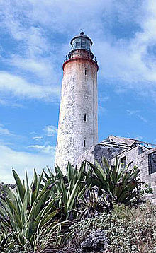
Ragged Point Lighthouse
The lighthouse is placed at the easternmost point of the island.
See also
References
- Rowlett, Russ. "Lighthouses of Barbados". The Lighthouse Directory. University of North Carolina at Chapel Hill. Retrieved December 18, 2015.
External links
- (in French) De sommet en sommet, les Alpes en péril (broadcast to French/German TV Arte) : Ragged point as the best spot for climatologists to monitor cloud formations in the Caribbean Sea, like Hawaii for the Pacific High ; hence the German Max Planck Institute for Meteorology settled a Climate research center there.
This Barbados location article is a stub. You can help Misplaced Pages by expanding it. |