| Revision as of 20:13, 15 December 2021 editSuperglasshouse (talk | contribs)105 editsNo edit summary← Previous edit | Revision as of 16:28, 10 January 2022 edit undoEastern Geek (talk | contribs)569 edits →Recent historyNext edit → | ||
| Line 50: | Line 50: | ||
| The Port is part of the ''California’s Green Trade Corridor Marine Highway'' project, as ships move cargo much greener than trucks and trains. Green Trade Corridor Marine Highway (ports of Oakland-Stockton-West Sacramento) can improve goods movement through Northern California.<ref></ref> | The Port is part of the ''California’s Green Trade Corridor Marine Highway'' project, as ships move cargo much greener than trucks and trains. Green Trade Corridor Marine Highway (ports of Oakland-Stockton-West Sacramento) can improve goods movement through Northern California.<ref></ref> | ||
| In June 2016, The Oakland City Council voted unanimously to ban the handling and storage of both coal and coke at the port. The Oakland City Council voted to ban the handling and storage of coal and coke at the city’s terminals and bulk material facilities. This decision came in opposition to developer ], CEO of the California Capital and Investment Group, |
In June 2016, The Oakland City Council voted unanimously to ban the handling and storage of both coal and coke at the port. The Oakland City Council voted to ban the handling and storage of coal and coke at the city’s terminals and bulk material facilities. This decision came in opposition to developer ], CEO of the California Capital and Investment Group, financiers of the forthcoming Oakland Bulk and Oversized Terminal.<ref></ref> | ||
| ==Oakland Ballpark== | ==Oakland Ballpark== | ||
Revision as of 16:28, 10 January 2022
Container ship facility in Oakland, California| Port of Oakland | |
|---|---|
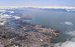
 Aerial view of the port of Oakland Aerial view of the port of Oakland | |
| Click on the map for a fullscreen view | |
| Location | |
| Country | United States |
| Location | Oakland, California |
| Coordinates | 37°47′43.92″N 122°17′4.57″W / 37.7955333°N 122.2846028°W / 37.7955333; -122.2846028 |
| Details | |
| Opened | 1927 |
| No. of berths | 20 |
| Draft depth | 50 feet |
| Air draft | 220 feet, restricted by Golden Gate Bridge |
| Statistics | |
| Vessel arrivals | 1,775 (FY 2014) |
| Annual container volume | 2,394,069 twenty-foot equivalent units (TEU) (FY 2014) |
| Website http://www.portofoakland.com/ | |
The Port of Oakland is a major container ship facility located in Oakland, California, in the San Francisco Bay. It was the first major port on the Pacific Coast of the United States to build terminals for container ships. As of 2011 it was the fifth busiest container port in the United States, behind Long Beach, Los Angeles, Newark, and Savannah. Development of an intermodal container handling system in 2002 culminated over a decade of planning and construction to produce a high volume cargo facility that positions the Port of Oakland for further expansion of the West Coast freight market share. In 2019 it ranked 8th in the United States in the category of containers.
Early history
| This section's tone or style may not reflect the encyclopedic tone used on Misplaced Pages. See Misplaced Pages's guide to writing better articles for suggestions. (October 2020) (Learn how and when to remove this message) |
Originally, the estuary, 500 feet (150 m) wide, had a depth of two feet at mean low tide. In 1852, the year of Oakland's incorporation as a town by the California State Legislature, large shipping wharves were constructed along the Oakland Estuary, which was dredged to create a viable shipping channel. 22 years later, in 1874, the previously dredged shipping channel was deepened to make Oakland a deep water port.
In the late 19th century, the Southern Pacific was granted exclusive rights to the port, a decision the city soon came to regret. In January 1906, a small work party in the employ of the Western Pacific Railroad, which had just begun construction, hastily threw a crossing over the SP line to connect the WP mainline with trackage built on an area of landfill. This act, protested by the SP and later upheld in court, broke the railroad's grip on the port area. The courts ruled that all landfill since the date of the agreement did not belong to the SP. This ruling ended SP control and made the modern Port of Oakland possible.
On May 6, 1915, the Admiral Dewey became the first vessel to dock at the foot of Clay street. Captain J. Daniels, master of the vessel, was greeted by Commissioner of Public Works Harry S. Anderson and Harbor Manager W.W. Keith, the two men who had so much to do with the upbuilding of the city's waterfront, were the first aboard the boat. "Captain do you realize that you are the commander of the first big vessel that has ever tied up to what will eventually be the busiest wharf on the Pacific Coast?" Anderson asked that official as he shook Captain J. Daniels hand. "I certainly do realize that, Mr. Anderson." returned Captain Daniels, "and I assure you that I appreciate the honor. I've been many years on the sea, but I have never docked a ship at a better wharf than this."-Source Oakland Tribune May 7, 1915. The project in 1921 dug a channel thirty feet deep at mean low water from the bay to Brooklyn Basin, a distance of four and three quarters miles, and then a channel twenty-five feet deep around the basin and eighteen feet to San Leandro Bay, an added distance of four miles (6 km). However, the port was not officially named the Port of Oakland until 1927, under the leadership of the newly organized Board of Port Commissioners.
Under the Rivers and Harbors Act of 1922, the project produced the channel thirty feet deep and 800 feet wide through the shoal south of Yerba Buena Island narrowing to 600 feet at the end of the Oakland jetties, widening of the estuary channel to 600 feet to Webster Street, dredging of the south channel basin to thirty feet and a turning basin, then thirty feet to Park street, at a cost to the federal government of $6 million.
In 1962, the Port of Oakland began to admit container ships. Container traffic greatly increased the amount of cargo loaded and unloaded in the Port. By the late 1960s, the Port of Oakland was the second largest port in the world in container tonnage. However, depth and navigation restrictions in San Francisco Bay limited its capacity, and by the late 1970s it had been supplanted by the Ports of Los Angeles and Long Beach as the major container port on the West Coast.
During an expansion of the Port in the late 1960s, fill material was added to what remained of the old Southern Pacific mole. The fill came largely from the concurrent excavation of the Berkeley Hills Tunnel during the construction of the BART system. The BART trunk line also crosses over part of the port, and the east portal of the Transbay Tube that carries BART trains from Oakland to San Francisco lies within the Port.
Recent history


One of the main limitations to growth was the inability to transfer containers to rail lines, all cranes historically operating between ocean vessels and trucks. In the 1980s the Port of Oakland began the evaluation of development of an intermodal container transfer capability, i.e. facilities that would allow trans-loading of containers from vessels to either trucks or rail modes. The Port retained VZM, Korve Engineering and Earth Metrics to perform engineering and environmental studies to allow detailed engineering to proceed. In 1987, on behalf of the Oakland Port Commission, Allen Broussard led a group of 72 lawyers, port officials including: then-port commissioner Carole Ward Allen, and city officials on a 3-week long trip to China meeting the Mayor of Shanghai, Jiang Zemin (Shanghai is twinned with San Francisco)
Completion of the resulting rail intermodal facility occurred in 2002. That brought the cumulative investment of port expansion to over $1.4 billion since 1962, half of which comprised the intermodal facility. In the early first decade of the 21st century, the new intermodal rail facility along with severe congestion at the Ports of Los Angeles and Long Beach caused some trans-Pacific shippers to move some of their traffic to the Port of Oakland (especially if the final destination is not in Southern California but lies farther east). Also, the Port is now reaping the benefits of investment in post-panamax cranes, dredging, and the transfer of military property, which has now been used for expansion.
Deepening of the port from 42 feet (13 m) to 50 feet (15 m) to accommodate larger ships has been completed. The ports of Los Angeles, Long Beach, Seattle and Tacoma were already 50 feet (15 m) deep. The $432 million project was finished in September 2009. Some 6 million cubic yards (4,600,000 m) of mud from the dredging was deposited at the western edge of Middle Harbor Shoreline Park to become a 188-acre (76 ha) shallow-water wetlands habitat for marine and shore life. Further dredging followed in 2011, to maintain the navigation channel. Prior to the March 2012 arrival of the MSC Fabiola, the largest container ship ever to enter the San Francisco Bay, the Port of Oakland prepared by checking channel depth and dredging as needed. The ship arrived drawing less than its full draft of 50 feet 10 inches (15.5 m) because it held only three-quarters of a load.
Occupy Oakland, part of the Occupy movement, marched to the port on November 2, 2011, and blocked traffic from entering and leaving. In August 2014, the port was the scene of a protest against an Israeli-owned ship by Palestinian supporters opposed to Israeli military actions in the Gaza Strip. The ship's cargo was eventually unloaded after a 4-day standoff. The Jewish Press commented that unless the port found a solution to their "protester problem," there was a good chance the ship's owner and other cargo firms would find safer ports to do business with.
The Port is part of the California’s Green Trade Corridor Marine Highway project, as ships move cargo much greener than trucks and trains. Green Trade Corridor Marine Highway (ports of Oakland-Stockton-West Sacramento) can improve goods movement through Northern California.
In June 2016, The Oakland City Council voted unanimously to ban the handling and storage of both coal and coke at the port. The Oakland City Council voted to ban the handling and storage of coal and coke at the city’s terminals and bulk material facilities. This decision came in opposition to developer Phil Tagami, CEO of the California Capital and Investment Group, financiers of the forthcoming Oakland Bulk and Oversized Terminal.
Oakland Ballpark
Main article: Oakland BallparkThe Oakland Athletics of Major League Baseball plan on constructing a new ballpark for the team at Howard Terminal. On April 26, 2018, the Port of Oakland commissioners voted 6-0 unanimously to enter in to a one-year agreement to negotiate exclusively with the Oakland A’s. This agreement allows the A’s to pay the Port $100,000 to study economic feasibility and environmental, transportation and accessibility issues.
On November 28, 2018, The Athletics announced that the team had chosen to build its 34,000-seat new ballpark at the Howard Terminal site at the Port of Oakland.
Oakland International Airport
Main article: Oakland International AirportIn addition to its maritime activities, the Port also operates Oakland International Airport. Developed land adjacent to the airport is also overseen by the Port, including the Airport Business Park.
Gallery
-
 Aerial view, with Alameda Island and the bay
-
 A view of the port
-
 The port with Oakland in the background
-
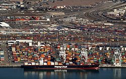
 A ship in the port
-
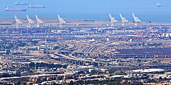
 Cranes in the port
-
Middle Harbor Shoreline Park in the center of the port
-
A dredge in the port with San Francisco in the background
See also
References
- ^ Port of Oakland Maritime Operations at a Glance
- http://aapa.files.cms-plus.com/Statistics/NORTH%20AMERICA%20PORT%20CONTAINER%20TRAFFIC%20RANKING%202011.pdf
- https://explore.dot.gov/views/PortProfiles2020/ProfileDashboard?%3AisGuestRedirectFromVizportal=y&%3Aembed=y
- Berkeley Gazette, October 24, 1966, p.13
- Initial Study: Intermodal Interface Demonstration Project, Port of Oakland, Oakland, California, Earth Metrics and Korve Engineerning, December 20, 1989
- In Memoriam: Honorable Allen E. Broussard (1929 – 1996)
- Port of Oakland Official Site: Facts and Figures (2006) Archived 2013-08-08 at the Wayback Machine
- Port of Oakland digs deep for greater capacity
- Port of Oakland (September 21, 2009). "Port of Oakland, California, completes 50-foot-deepening project, allowing it to accommodate larger container ships". Industry Intelligence. Archived from the original on February 1, 2014. Retrieved March 23, 2012.
- "USA: Port of Oakland Secures USD 18 Million in Federal Funding for Dredging Project". Dredging Today. June 1, 2011. Retrieved March 22, 2012.
- "USA: Congresswoman Helps Oakland Port Reach Major Funding Milestone for Deepening Project". Dredging Today. March 21, 2012. Retrieved March 22, 2012.
- Matthews, Mark (March 22, 2012). "Huge container ship cruises into Port of Oakland". ABC7. San Francisco: KGO-TV/DT. Archived from the original on September 15, 2012. Retrieved March 23, 2012.
- Bulwa, Demian, Matthai Kuruvila, and Kevin Fagan (November 2, 2011). "Occupy Oakland throng closes down port". The San Francisco Chronicle. Retrieved November 5, 2011.
{{cite news}}: CS1 maint: multiple names: authors list (link) - "Demonstration on U.S. dock prevents workers from unloading Israeli ship". San Francisco Star. 19 August 2014. Retrieved 19 August 2014.
- "ILWU distances union from Gaza protest at Oakland". CBS. 20 August 2014. Retrieved 20 August 2014.
- portofoakland.com, California Green Trade Corridor
- 1467106207
- "Port of Oakland OKs A's wish to study Howard Terminal ballpark". The Mercury News. 2018-04-27. Retrieved 2018-10-20.
- "A's settle on a ballpark site and a futuristic stadium". The Mercury News. 2018-11-28. Retrieved 2018-11-28.
- "Archived copy". Archived from the original on 2012-05-10. Retrieved 2012-04-06.
{{cite web}}: CS1 maint: archived copy as title (link)
External links
- Port of Oakland Official website
- http://www.nytimes.com/2016/09/19/business/economy/coming-soon-economists-hope-big-spending-on-roads-bridges-and-ports.html?_r=1
37°47′43.92″N 122°17′4.57″W / 37.7955333°N 122.2846028°W / 37.7955333; -122.2846028
| Panamax ports | |
|---|---|
| Non-Panamax ports | |
| Canals | |
| Alternate West Coast seaports | |
| West Coast LNG terminals | |
| San Francisco Bay watershed | ||
|---|---|---|
| Outline |  | |
| Subdivisions | ||
| Waterways |
| |
| Parks and protected areas |
| |
| Islands and peninsulas |
| |
| Wetlands | ||
| Bridges and tubes | ||
| Ferries | ||
| Ports and marinas | ||
| Other |
| |