| Revision as of 18:10, 6 March 2022 editDušan Kreheľ (bot) (talk | contribs)7,016 edits Infobox.← Previous edit | Revision as of 22:05, 31 March 2022 edit undoDušan Kreheľ (bot) (talk | contribs)7,016 edits Infobox.Next edit → | ||
| Line 36: | Line 36: | ||
| <!-- area --> | <!-- area --> | ||
| | area_footnotes = | | area_footnotes = | ||
| | area_total_km2 = 6.09<ref name="area">{{Cite web |url=http://datacube.statistics.sk/#!/view/sk/VBD_DEM/om7014rr/v_om7014rr_00_00_00_sk |title=Hustota obyvateľstva - obce |language=sk |date= |
| area_total_km2 = 6.09<ref name="area">{{Cite web |url=http://datacube.statistics.sk/#!/view/sk/VBD_DEM/om7014rr/v_om7014rr_00_00_00_sk |title=Hustota obyvateľstva - obce |language=sk |date=2022-03-31 |website=www.statistics.sk |publisher= Statistical Office of the Slovak Republic|access-date=2022-03-31}}</ref> | ||
| | area_total_sq_mi = 2.35<ref name="area"/> | | area_total_sq_mi = 2.35<ref name="area"/> | ||
| | area_land_sq_mi = | | area_land_sq_mi = | ||
| Line 42: | Line 42: | ||
| <!-- elevation --> | <!-- elevation --> | ||
| | elevation_footnotes = | | elevation_footnotes = | ||
| | elevation_m = 223<ref name="base_info">{{Cite web |url=http://datacube.statistics.sk/#!/view/sk/VBD_SK_WIN/om5001rr/v_om5001rr_00_00_00_sk |title=Základná charakteristika |language=sk |date=2015-04-17 |website=www.statistics.sk |publisher= Statistical Office of the Slovak Republic|access-date= |
| elevation_m = 223<ref name="base_info">{{Cite web |url=http://datacube.statistics.sk/#!/view/sk/VBD_SK_WIN/om5001rr/v_om5001rr_00_00_00_sk |title=Základná charakteristika |language=sk |date=2015-04-17 |website=www.statistics.sk |publisher= Statistical Office of the Slovak Republic|access-date=2022-03-31}}</ref> | ||
| | elevation_ft = 732<ref name="base_info"/> | | elevation_ft = 732<ref name="base_info"/> | ||
| | population_as_of = {{abbr| |
| population_as_of = {{abbr|2021|Population: 2020-12-31. Population density & Total area: 2020-06-30/-07-01. Elevation, Postal code & Area code (last updated): 2015-04-17.}} | ||
| | population_footnotes = | | population_footnotes = | ||
| | population_total = |
| population_total = 828<ref>{{Cite web |url=http://datacube.statistics.sk/#!/view/sk/VBD_DEM/om7101rr/v_om7101rr_00_00_00_sk |title=Počet obyvateľov podľa pohlavia - obce (ročne) |language=sk |date=2022-03-31 |website=www.statistics.sk |publisher= Statistical Office of the Slovak Republic|access-date=2022-03-31}}</ref> | ||
| | population_density_km2 = |
| population_density_km2 = 136.08<ref name="pd">{{Cite web |url=http://datacube.statistics.sk/#!/view/sk/VBD_DEM/om7014rr/v_om7014rr_00_00_00_sk |title=Hustota obyvateľstva - obce |language=sk |date=2022-03-31 |website=www.statistics.sk |publisher= Statistical Office of the Slovak Republic|access-date=2022-03-31}}</ref> | ||
| | population_density_sq_mi= |
| population_density_sq_mi= 52.54<ref name="pd"/> | ||
| | population_demonym = | | population_demonym = | ||
| <!-- time zone(s) --> | <!-- time zone(s) --> | ||
Revision as of 22:05, 31 March 2022
Municipality in Slovakia| Hrnčiarske Zalužany | |
|---|---|
| Municipality | |
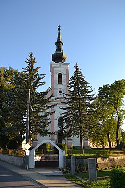
 Church of the Assumption Church of the Assumption | |
  | |
| Coordinates: 48°24′N 19°52′E / 48.400°N 19.867°E / 48.400; 19.867 | |
| Country | |
| Region | Banská Bystrica |
| District | Poltár |
| First mentioned | 1362 |
| Area | |
| • Total | 6.09 km (2.35 sq mi) |
| Elevation | 223 m (732 ft) |
| Population | |
| • Total | 828 |
| Postal code | 980 12 |
| Area code | +421 47 |
| Car plate | PT |
| Website | www.hrnciarskezaluzany.sk |
Hrnčiarske Zalužany is a village and municipality in the Poltár District in the Banská Bystrica Region of Slovakia. During history the inhabitants had been engaged in the production of pottery. At the end of 18th century in Hrnčiarske Zalužany existed the production of bricks and skids. Pottery production still exists, in the village is production cooperative and quite a few small private producers.
See also
References
- "Počet obyvateľov podľa pohlavia - obce (ročne)". www.statistics.sk (in Slovak). Statistical Office of the Slovak Republic. 2022-03-31. Retrieved 2022-03-31.
- ^ "Hustota obyvateľstva - obce [om7014rr_ukaz: Rozloha (Štvorcový meter)]". www.statistics.sk (in Slovak). Statistical Office of the Slovak Republic. 2022-03-31. Retrieved 2022-03-31.
- ^ "Základná charakteristika". www.statistics.sk (in Slovak). Statistical Office of the Slovak Republic. 2015-04-17. Retrieved 2022-03-31.
- ^ "Hustota obyvateľstva - obce". www.statistics.sk (in Slovak). Statistical Office of the Slovak Republic. 2022-03-31. Retrieved 2022-03-31.
- http://www.hrnciarskezaluzany.sk/index.html
Genealogical resources
The records for genealogical research are available at the state archive "Statny Archiv in Banska Bystrica, Slovakia"
- Roman Catholic church records (births/marriages/deaths): 1716-1900 (parish B)
External links
 Media related to Hrnčiarske Zalužany at Wikimedia Commons
- Official website

- Surnames of living people in Hrnciarske Zaluzany
| Municipalities of Poltár District | ||
|---|---|---|
This Banská Bystrica Region geography article is a stub. You can help Misplaced Pages by expanding it. |