|
''']''' (1767–1838) was an American lawyer, judge, and ] who served as Assistant Postmaster General for 30 years during the earliest history of the ]. He was responsible for moving the federal government's post office from ], to the new capital at ], and briefly hosted the national post office in his own home. The continuity brought by Bradley's long employment during the tenures of five ] helped establish the budding postal service as a reliable provider; he also drew detailed and innovative postal route maps that built the office's efficiency. He drew one of the first comprehensive maps of the United States in 1796; it "represented the first clear cartographic break in European-dominated map making and introduced a new, more distinctly American style of cartography to the United States". In 1804, Bradley drew this map of ]s and ]s in the United States, spanning the ] (now ]) in the southwest to ] in the northeast. The hand-colored map measures 98 by 132 centimeters (39 in × 52 in). |
|
''']''' (1767–1838) was an American lawyer, judge, and ] who served as Assistant Postmaster General for 30 years during the earliest history of the ]. He was responsible for moving the federal government's post office from ], to the new capital at ], and briefly hosted the national post office in his own home. The continuity brought by Bradley's long employment during the tenures of five ] helped establish the budding postal service as a reliable provider; he also drew detailed and innovative postal route maps that built the office's efficiency. He drew one of the first comprehensive maps of the United States in 1796; it "represented the first clear cartographic break in European-dominated map making and introduced a new, more distinctly American style of cartography to the United States". In 1804, Bradley drew this map of American ]s and ]s, spanning the ] (now ]) in the southwest to ] in the northeast. The hand-colored map measures 98 by 132 centimeters (39 in × 52 in). |
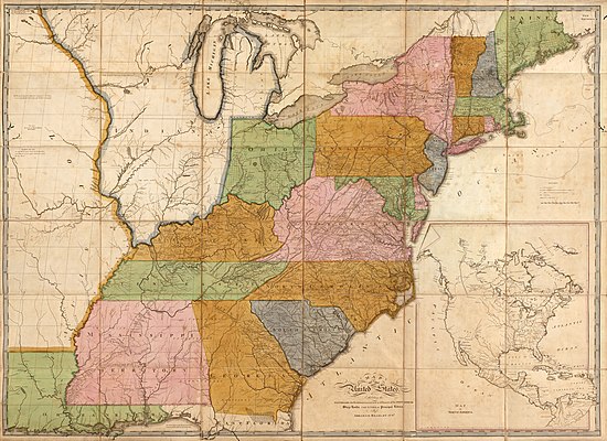
 Abraham Bradley Jr. (1767–1838) was an American lawyer, judge, and cartographer who served as Assistant Postmaster General for 30 years during the earliest history of the United States Post Office Department. He was responsible for moving the federal government's post office from Philadelphia, Pennsylvania, to the new capital at Washington, D.C., and briefly hosted the national post office in his own home. The continuity brought by Bradley's long employment during the tenures of five United States postmasters general helped establish the budding postal service as a reliable provider; he also drew detailed and innovative postal route maps that built the office's efficiency. He drew one of the first comprehensive maps of the United States in 1796; it "represented the first clear cartographic break in European-dominated map making and introduced a new, more distinctly American style of cartography to the United States". In 1804, Bradley drew this map of American post roads and post offices, spanning the Orleans Territory (now Louisiana) in the southwest to Maine in the northeast. The hand-colored map measures 98 by 132 centimeters (39 in × 52 in).Map credit: Abraham Bradley Jr.
Archive – More featured pictures...