| Revision as of 20:28, 19 March 2007 editGreenrd (talk | contribs)Extended confirmed users14,722 editsm Robot-assisted disambiguation: Field← Previous edit | Revision as of 12:49, 30 March 2007 edit undoGavin.collins (talk | contribs)18,503 editsmNo edit summaryNext edit → | ||
| Line 6: | Line 6: | ||
| '''Bushy Park''' is the second largest of the ]. It is in south-west ], in the ]. | '''Bushy Park''' is the second largest of the ]. It is in south-west ], in the ]. | ||
| 1100 acres (4.5 km²) in area, Bushy Park lies immediately north of ] and ], a few minutes' walk west of ]. It includes fishing and model boating ponds, horse rides, formal plantations of trees and other plants, wild areas of bracken inhabited by deer, and wildlife conservation areas. It is also home to several lodges and cottages, the ], the ] and two areas of ], the ] at ] and the ] at ]. | 1100 acres (4.5 km²) in area, Bushy Park lies immediately north of ] and ], a few minutes' walk west of ]. It includes fishing and model boating ponds, horse rides, formal plantations of trees and other plants, wild areas of bracken inhabited by deer, and wildlife conservation areas. It is also home to several lodges and cottages, the ], the ], ] and two areas of ], the ] at ] and the ] at ]. | ||
| == History == | == History == | ||
Revision as of 12:49, 30 March 2007
- Bushy Park is also the name of a town in the central highlands of Tasmania, Australia. For the park in Melbourne, Australia, see Bushy Park Wetlands.

Template:Royal Parks of London
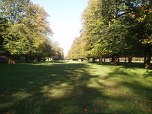
Bushy Park is the second largest of the Royal Parks of London. It is in south-west London, in the borough of Richmond upon Thames.
1100 acres (4.5 km²) in area, Bushy Park lies immediately north of Hampton Court Palace and Hampton Court Gardens, a few minutes' walk west of Kingston upon Thames. It includes fishing and model boating ponds, horse rides, formal plantations of trees and other plants, wild areas of bracken inhabited by deer, and wildlife conservation areas. It is also home to several lodges and cottages, the National Physical Laboratory, the Royal Paddocks, Hampton Wick Royal Cricket Club and two areas of allotments, the Royal Paddocks Allotments at Hampton Wick and the Bushy Park Allotments at Hampton Hill.
History
The area now known as Bushy Park has been settled for at least the past 4000 years: the earliest archaeological records that have been found on the site date back to the Bronze Age. There is also evidence that the area was used in the Medieval period as fields.

When Henry VIII took over Hampton Court Palace from Thomas Cardinal Wolsey in 1529, the King also took over the three parks that make up modern day Bushy Park: Hare Warren, Middle Park and Bushy Park. A keen hunter, he established them as deer-hunting grounds.
His successors, perhaps less bloodthirsty, added a number of picturesque features, including the Longford River, a 19 kilometre canal built on the orders of Charles I of England to provide water to Hampton Court, as well as the Park's various ponds. This period also saw the construction of the Park's main thoroughfare, Chestnut Avenue, which runs between Hampton Court Road in Hampton and Sandy Lane in Teddington. This Avenue and the Diana Fountain it leads to were designed by Sir Christopher Wren.

The Park has long been popular with locals, but also attracts those from further afield. From the mid nineteenth Century until World War II Londoners celebrated Chestnut Sunday here, coming to see the blooming of the trees along Chestnut Avenue (this tradition resumed in 1993). During the late 1800s, the modern game of field hockey was largely invented at Bushy.
During World War I, Bushy Park was home to the King's Canadian Hospital, and between the wars hosted a camp for undernourished children. During World War II, General Dwight D. Eisenhower planned the D-Day landings from Supreme Headquarters Allied Expeditionary Force (SHAEF) in the Park. A memorial to this has been laid in the park to mark the spot where General Dwight D. Eisenhower's tent stood. It was designed by Carlos Rey.
Getting there
The closest National Rail stations are Hampton Court to the south, Hampton Wick and Kingston, both to the east, Teddington and Fulwell to the north, and Hampton to the west. All are within a 10- to 20-minute walk. Transport for London bus routes, including the 111, 216, 265, and 411 services all pass by the Hampton Court Gate (the main southern entrance to the Park). The R68 service from Richmond serves other entrances at Hampton Court Green.
It is home to the Royal Paddocks, Bushy House and the National Physical Laboratory, and is close by Hampton Court Gardens and Park.
See also
External links
51°24′46″N 0°20′17″W / 51.41278°N 0.33806°W / 51.41278; -0.33806
Categories:

