| Revision as of 09:01, 25 December 2024 editDicklyon (talk | contribs)Autopatrolled, Extended confirmed users, Rollbackers476,405 edits case fix← Previous edit | Revision as of 09:03, 25 December 2024 edit undoDicklyon (talk | contribs)Autopatrolled, Extended confirmed users, Rollbackers476,405 edits case fixNext edit → | ||
| Line 20: | Line 20: | ||
| |image_map = Map of the departments of the Saint-Louis region of Senegal.png | |image_map = Map of the departments of the Saint-Louis region of Senegal.png | ||
| |mapsize =320px | |mapsize =320px | ||
| |map_caption = Location in the Saint-Louis |
|map_caption = Location in the Saint-Louis region | ||
| |pushpin_map = <!-- the name of a location map as per http://en.wikipedia.org/Template:Location_map --> | |pushpin_map = <!-- the name of a location map as per http://en.wikipedia.org/Template:Location_map --> | ||
| |pushpin_label_position =bottom | |pushpin_label_position =bottom | ||
| Line 29: | Line 29: | ||
| |subdivision_name = {{flag|Senegal}} | |subdivision_name = {{flag|Senegal}} | ||
| |subdivision_type1 = ] | |subdivision_type1 = ] | ||
| |subdivision_name1 = ] | |subdivision_name1 = ] | ||
| |subdivision_type2 =Capital | |subdivision_type2 =Capital | ||
| |subdivision_name2 = ] | |subdivision_name2 = ] | ||
Revision as of 09:03, 25 December 2024
Department in Saint-Louis region, Senegal| Podor | |
|---|---|
| Department | |
 Village street and mosque in Podor Village street and mosque in Podor | |
 Location in the Saint-Louis region Location in the Saint-Louis region | |
| Country | |
| Region | Saint-Louis region |
| Capital | Podor |
| Area | |
| • Total | 12,947 km (4,999 sq mi) |
| Population | |
| • Total | 487,220 |
| • Density | 38/km (97/sq mi) |
| Time zone | UTC+0 (GMT) |
Podor department is one of the 46 departments of Senegal and one of the three in the Saint-Louis region in the far north-west of the country.
Communes in the department are:
- Golléré
- Ndiandane
- Ndioum
- Podor
- Mboumba
- Guédé Chantier
- Démette
- Galoya Toucouleur
- Aéré Lao
- Pété
- Walaldé
- Bodé Lao
Rural districts (Communautés rurales) comprise:
- Arrondissement of Cas-Cas
- Méry
- Doumga Lao
- Madina Diathbé
- Arrondissement of Gamadji Saré
- Gamadji Saré
- Dodel
- Guédé Village
- Arrondissement of Saldé
- Mbolo Birane
- Boké Dialloubé
- Arrondissement of Thillé Boubacar
- Fanaye
- Ndiayène Peindao
Historic sites

- The Fort at Podor
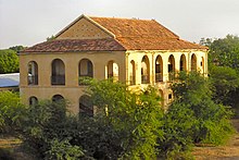
- Maison Foy at the corner of the quay in Podor
- The quays and quay buildings of Podor
- The mosque at Alwar
- The Almamy cemetery at Mboumba
- The old mosque at Mboumba
- The mosque and mausoleum of Ouro Madiou
- The mosque of Diama Alwaly
- The old village of Walaldé
- The old village of Siouré
- The old village of Kaskas
- The mosque of Guédé Ouro
- The old village of Tioubalel
References
16°38′56″N 14°57′39″W / 16.64889°N 14.96083°W / 16.64889; -14.96083
This Senegal location article is a stub. You can help Misplaced Pages by expanding it. |