| Revision as of 23:21, 15 May 2007 editJ Bar (talk | contribs)Extended confirmed users16,862 editsm tidy up← Previous edit | Revision as of 04:49, 19 May 2007 edit undo125.63.129.114 (talk)No edit summaryNext edit → | ||
| Line 26: | Line 26: | ||
| '''Enmore''' is a ] in the ] of ], in the state of ], ]. Enmore is located 5 kms south-west of the ] and is part of the ] of ]. The postcode is 2042. | '''Enmore''' is a ] in the ] of ], in the state of ], ]. Enmore is located 5 kms south-west of the ] and is part of the ] of ]. The postcode is 2042. | ||
| full of retards and fags one resident has such a small penis that u need a microscope to see it.basically it is a shithole :)==Commercial Area== | |||
| ==Commercial Area== | |||
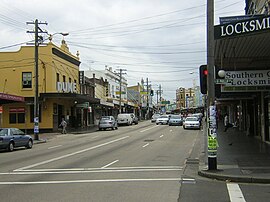
| Enmore is primarily residential, although there is a commercial strip along Enmore Road, which is an extension of the more famous ] in ]. | Enmore is primarily residential, although there is a commercial strip along Enmore Road, which is an extension of the more famous ] in ]. | ||
Revision as of 04:49, 19 May 2007
Suburb of Sydney, New South Wales, Australia| Enmore Sydney, New South Wales | |||||||||||||||
|---|---|---|---|---|---|---|---|---|---|---|---|---|---|---|---|
 Enmore Road shops Enmore Road shops | |||||||||||||||
| Population | 3581 (2001 census) | ||||||||||||||
| • Density | Lua error: Unable to convert population "3581 (2001 census)" to a number. | ||||||||||||||
| Postcode(s) | 2042 | ||||||||||||||
| Area | 0.4 km (0.2 sq mi) | ||||||||||||||
| LGA(s) | Marrickville Council | ||||||||||||||
| State electorate(s) | Marrickville | ||||||||||||||
| Federal division(s) | Grayndler | ||||||||||||||
| |||||||||||||||
Enmore is a suburb in the inner-west of Sydney, in the state of New South Wales, Australia. Enmore is located 5 kms south-west of the Sydney central business district and is part of the local government area of Marrickville Council. The postcode is 2042. full of retards and fags one resident has such a small penis that u need a microscope to see it.basically it is a shithole :)==Commercial Area== Enmore is primarily residential, although there is a commercial strip along Enmore Road, which is an extension of the more famous King Street in Newtown.
Schools
The suburb is home to the Design Campus of the Sydney Institute.
Culture
- The Enmore Theatre is a renowned live music and comedy venue.
- The Sly Fox, a lesbian/mixed pub. Both Enmore and Newtown have a significant gay and lesbian population.
- Enmore is also a focus for goth subculture in Sydney, with related speciality stores. Enmore Road hosts the annual 'Under the Blue Moon' goth festival.
History
Enmore was named after Enmore House, built in 1835 by Captain Sylvester Browne, a master mariner with the British East India Company. Browne named his house after the West Indian estate of a business associate, the head of James Cavan & Co, which in turn took its name from the London suburb. Browne's son wrote several Australian classics, including Robbery Under Arms, under the name of Rolf Boldrewood.
Enmore House was the home of the Josephson family from 1842 to its demolition in 1883. After his death his son Joshua Frey Josephson lived there until 1883. Joshua Frey Josephson had four sons and nine daughters from three marriages. One son, Joshua Percy Josephson was Mayor of Marrickville in 1901. Five streets are named after five daughters - Clara, Laura, Marian, Pearl and Sarah.
Notable Residents
- Rolf Boldrewood, also known as Thomas Alexander Browne, author of Robbery Under Arms.
References
- The Book of Sydney Suburbs, Compiled by Frances Pollen, Angus & Robertson Publishers, 1990, Published in Australia ISBN 0-207-14495-8
External links
Template:Mapit-AUS-suburbscale
| Suburbs and localities within Inner West Council, Inner West, Sydney | |
|---|---|
| List of Sydney suburbs |
This article related to the geography of Sydney is a stub. You can help Misplaced Pages by expanding it. |