| Revision as of 22:37, 2 December 2008 editCarlossuarez46 (talk | contribs)501,458 edits template← Previous edit | Revision as of 18:32, 21 December 2008 edit undoBaboner (talk | contribs)5 edits →List of Historic and Tourist Sites: sorry no caucasian teprles hereNext edit → | ||
| Line 37: | Line 37: | ||
| * ''Santepe'', an archaeological site referring back to 9th-8th centuries B.C. and the Iron Age. | * ''Santepe'', an archaeological site referring back to 9th-8th centuries B.C. and the Iron Age. | ||
| * ''] church, medieval Armenian church destroyed by the Azerbaijani soldiers in act of ]. | |||
| * ''The Avey ] Temple'', built in 5th-6th century A.D. at the southern peak of Mount Avey. | |||
| * ''The Qazakhbeyli Hills'', an archaeological site referring to the 8th-6th centuries B.C. near the village of Qazakhbeyli. | * ''The Qazakhbeyli Hills'', an archaeological site referring to the 8th-6th centuries B.C. near the village of Qazakhbeyli. | ||
Revision as of 18:32, 21 December 2008

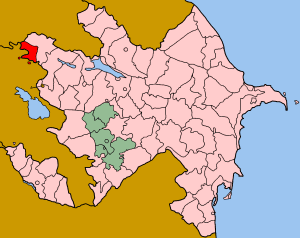
Qazakh (Template:Lang-az; also known as Kazakh or Gazakh) is a rayon of Azerbaijan. It has two exclaves inside Armenia, Yukhari Askipara and Barkhudarli, both of which came under Armenian control during the Nagorno-Karabakh War.
History
In antiquity, this rayon was part of Utik, a historic province of Caucasian Albania as described by Greco-Roman historians. Around 5th-7th centuries A.D., the local historian Movses Kaghankatvatsi as well as the medieval Armenian historians Movses Khorenatsi and Hovannes Draskhanakertsi referred to the region as the "Albanian plain". The region was eventually conquered by several neighboring powers including the Sassanid Persians, the Byzantine Greeks, the Arabs, the Seljuq Turks, the Georgians, the Mongols, the Timurids, the Kara Koyunlu and Ak Koyunlu Turkoman tribes, and finally the Safavid Iran.
After the Russo-Persian War (1804-1813), the Russian Empire gained control of the area by virtue of the Treaty of Gulistan. Under Russian rule, it formed the northeastern part of the Kazakh uyezd of the Elisabethpol Governorate. A contemporary military historian noted the following ethnographic detail: "Abbas Mirza's route lay through the country of the great tribe of the Casaks, which is extremely strong and thickly wooded." He further notes that: "These have no connection with the Russian Cossacks. They are descended from men of the Kirgis Casaks, left by Genghis Khan, and are Mahomedans of the Soonnie sect. They are frequently called Kara Papaks, from wearing black sheep-skin caps."
With the fall of the Russian Empire, dispute over the region arose between the Armenians (who made up 39% of the population) and the Azerbaijanis (who comprised 57%). When the South Caucasus came under British occupation, Sir John Oliver Wardrop, British Chief Commissioner in the South Caucasus, decided that assigning the Erivan Governorate and the Kars Oblast to Democratic Republic of Armenia (DRA) and the Elisabethpol and Baku Governorates to the Azerbaijan Democratic Republic (ADR) would solve the region's outstanding disputes. However, this proposal was rejected by both Armenians (who did not wish to give up their claims to Kazakh, Zangezur (today Syunik), and Nagorno-Karabakh) and Azerbaijanis (who found it unacceptable to give up their claims to Nakhichevan). As conflict broke out between the two groups, the British left the region in mid-1919.
After the British evacuation and more fighting between Armenians and Azerbaijanis ensued, the Soviet Eleventh Army led by Grigoriy Ordzhonikidze gained control of the region which was later incorporated into the Soviet Union as part of the Transcaucasian SFSR. During the process of Sovietization, the borders of the Transcaucasian republics were redrawn several times. The territory of the former Kazakh uyezd was eventually divided between the Armenian and Azerbaijani republics along ethnic and sectarian lines. The northern region, including the town of Qazakh itself was given to Azerbaijan while the southern portion, roughly corresponding to the present-day Armenian province Tavush was given to Armenia. During the Nagorno-Karabakh War, Armenia gained control of Qazakh's exclaves of Yukhari Askipara and Barkhudarli. Besides this, neither country has disputed the boundary since.
List of Historic and Tourist Sites
There are 112 protected monuments in the region of Qazakh, of which, 54 are of archaeological, 46 - of architectural, 7 - of historical, and 5 - of artistic significance. Among such famous monuments are:
- The House of the Poetry of Samad Vurgun in the village Yukhari Salahli, since 1976.
- The Museum of History and Ethnography, since 1984.
- The Qazakh State Picture Gallery by the Ministry of Culture of Azerbaijan, since 1986.
- The Memorial museum of Molla Panah Vagif and Molla Vali Vidadi, since 1970.
- The House of Teachers Seminary of Qazakh, built in 1910, functioned between 1918 and 1959.
- The Bath House of Israfil Agha, built in the first decade of the 20th century by Israfil Agha Kerbelayev from the village of Kasaman.
- The Damjili Caves, in the village of Dash Salahli, south-east of the mount Avey, cover an area of 360 km and refer to Middle and Upper Paleolithic, Mesolithic and Neolithic eras.
- Sinig Korpu (The Broken Bridge) (Template:Lang-az), 12th century bridge built over the Ehram (Khram) river in the village Ikinji Shikhli.
- The Didevan Castle (Template:Lang-az), 6th-7th century monument in the village of Khanliglar.
- Mount Goyazan Template:Lang-az), a rare archaeological monument in the village of Abbasbeyli, rises 857.9 meters above the sea level.
- The Baba Dervish Habitation, an archaeological site in the village Demirchiler.
- The Kazim Bridge in the village of Yukhari Askipara, allegedly built during the reign of Shamsi Khan.
- The Juma Mosque of Qazakh, built in 1902 by Akhund Haji Zeynalabdin Mahammadli Oglu from the village of Kasaman.
- The Aslanbeyli Mosque built in 1909 by Hamid Efendi, the native of village Aslanbeyli.
- Santepe, an archaeological site referring back to 9th-8th centuries B.C. and the Iron Age.
- St. Sargis of Gag church, medieval Armenian church destroyed by the Azerbaijani soldiers in act of cultural genocide.
- The Qazakhbeyli Hills, an archaeological site referring to the 8th-6th centuries B.C. near the village of Qazakhbeyli.
- The Shikhli Human Camp, an archaeological site near the village of Birinji Shikhli.
Prominent people from Qazakh
- Ali-Agha Shikhlinski - (1865-1943) general-lieutenant of the artillery, known as "God of Russian artillery".
- Farrukh Gayibov - (1889-1916) the first Azerbaijani pilot, was awarded the 4th class order of "Saint Georgi".
- Ibrahim aga Vakilov - (1853-1934) general, the first Azerbaijani military topographer.
- Javad bey Shikhlinski - (1876-1940) general-mayor, the commander of the division.
- Ibrahim bey Usubov - (1872-1920) general-mayor, the commander of the division.
- Mirza Huseyn afandi Gayibov - (1830-1917) the Chair of the Ecclesiastical Department of Transcaucasia.
- Molla Vali Vidadi - (1707-1809) prominent poet of Azerbaijan.
- Molla Panah Vagif - (1717-1797) prominent poet of Azerbaijan and social figure.
- Mukhtar Hajiyev - (1876-1938) the first chairman of Azerbaijan Central Executive Committee in 1921
- Samad Vurgun - (1906-1956) National Poet of Azerbaijan (the first who deserved this title)
- Osman Sarivelli - (1905-1990) national poet of Azerbaijan.
- Mehdi Huseyn - (1909-1964) National Writer of Azerbaijan. Prominent writer-dramatist, critic.
- Mirvarid Dilbazi - (1912-2001) national poet of Azerbaijan
- Amina Dilbazi - (1919) ballet-master. National Artist of Azerbaijan.
- Elazan Bayjan (Haji Hasanzadeh) - (1913-1989) poet-doctor. Set up private medical clinics in Freyburg, Germany.
- Ismayil Shykhly - (1919-1995) National Writer of Azerbaijan, scientist- pedagogue, social-political figure.
- Elmira Huseynova - (1933-1995) sculptor.
- Fatma Vakilova - (1912-1987) professor, doctor of geology-mineralogy sciences.
- Sayad Zeynalov - (1886-1942) deserved 4th class "Saint Georgi" order
- Teymur Bunyadov - (1928) academician, historian-ethnographer.
- Tahir Isayev, a.k.a. Serafino - (1922-2001) national hero of Italy.
- Ali Mustafayev - (1952-1991) National Hero of Azerbaijan.
Demographics
- Population:84.569
Azeris 99.8% (84.399)
Footnotes
- Moisey Kalankatuyski, "History of Caucasian Albanians", Book I, Chapter IV, translation into Russian by Sh. V.Smbatyan, Yerevan, 1984
- C. J. F. Dowsett, "The Albanian Chronicle of Mxit'ar Gosh", Bulletin of the School of Oriental and African Studies 21(1958), pp. 472-490
- Movses Khorenatsi, "History of Armenia", Book 2, Chapter 8, translated into Russian by G.Sarkisyan, Hayastan Publishing House: Yerevan, 1990
- Hovannes Draskhanakertsi, "History of Armenia", Chapter XXXI, translated into Russian by M.O.Darbinyan-Melikyan, Yerevan, 1984
- Lt-Gen. William Monteith, Kars and Erzeroum: With the Campaigns of Prince Paskiewitch, in 1828 and 1829; and an Account of the conquests of Russia beyond the Caucasus, from the time of Peter the Great to the Treaty of Turcoman Chie and Adrianople, London: Longman, 1856, p. 60
- Template:Ru icon Brockhaus and Efron Encyclopedic Dictionary. "Kazakh". St. Petersburg, Russia, 1890-1907
- ^ W.E.D. Allen (published 1927). New Political Boundaries in the Caucasus. The Geographical Journal.
{{cite book}}: Check date values in:|year=(help)CS1 maint: year (link)
