| Revision as of 11:42, 26 August 2009 editExcelsiorHH (talk | contribs)32 edits →France← Previous edit | Revision as of 19:34, 26 August 2009 edit undoErik9bot (talk | contribs)439,480 edits add Category:Articles lacking sources (Erik9bot)Next edit → | ||
| Line 82: | Line 82: | ||
| ] | ] | ||
| ] | ] | ||
| ] | |||
| ] | ] | ||
Revision as of 19:34, 26 August 2009
Map all coordinates using OpenStreetMapDownload coordinates as:


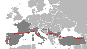
European route E 80 is an A-Class West-East European route, extending from Lisbon, Portugal to Gürbulak, Turkey, on the border with Iran. The road connects 11 countries and has a length of approx. 5700 kilometres (approx. 3540 miles).
Itinerary
Portugal
Spain
France
Monaco
Italy
Croatia
Montenegro
Kosovo
Serbia
Bulgaria
Turkey
Asian Highway 1
The E80 follows the Asian Highway 1 (AH1) and ![]() Road 32 through Turkey and crosses over the Bosporus via the Fatih Sultan Mehmet Bridge or the Second Bosphorus Bridge.
Road 32 through Turkey and crosses over the Bosporus via the Fatih Sultan Mehmet Bridge or the Second Bosphorus Bridge.
Coordinates
- Western Terminus - Lisbon 38°47′24.2″N 9°6′49.6″W / 38.790056°N 9.113778°W / 38.790056; -9.113778 (E80 Western Terminus)
- Eastern Terminus - Gürbulak 39°24′37″N 44°22′41.6″E / 39.41028°N 44.378222°E / 39.41028; 44.378222 (E80 Eastern Terminus)
This European road or road transport-related article is a stub. You can help Misplaced Pages by expanding it. |
<gallery> File:RouteE31.JPG|European route 80 near Parma, Italy. File:E 80 Dragoman.jpg|European route 80 near Dragoman, Bulgaria (border to Serbia). File:E 80 in Sofia.jpg|Bilingual sign to E 80 in Sofia.
Categories: